
MyTopo
Historic 1914 Lost Hills California 30'x30' Topo Map
Couldn't load pickup availability
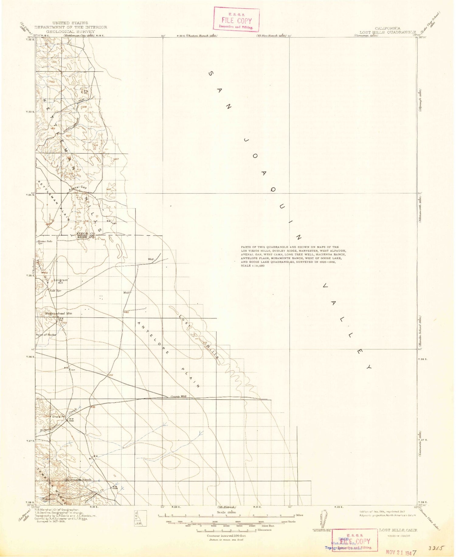
Historical USGS topographic map of Lost Hills in the state of California. Scale: 1:125000. Print size: 18" x 24"
This map was published in 1914 and is in the following counties: Kern, Kings, Tulare.
The map contains contour lines, roads, rivers, towns, streams, and lakes. Printed on high-quality waterproof paper with UV fade-resistant inks.
Contains the following named places: Antelope Plain, Bent Ranch, Blue Moon Ranch, Bull Slough, Burhans Ranch, Carmel Ranch, Cole Ranch, Crockett and Gambogy Ranch, Devils Den, Douglas Ranch, Dudley Ranch, Dudley Ridge, El Bulto, El Portillo, Emigrant Hill, Estrada Ranch, Gates-Jones Canal, Gilbert Ranch, Goose Lake Bed, Goose Lake Canal, Hacienda Ranch, Hacienda Spillway, Hannah Ranch, Homeland Canal, Houser Camp, Jerry Slough, Kern River Channel, La Bajada, Las Colinas, Las Lomas, Las Perillas, Liberty Farms East Canal, Liberty Farms South Canal, Lost Hills, Main Canal, Media Agua Creek, Mid Ridge, Middle Dome, Milham Farm, Pelican Island, Poso Canal, Sand Ridge, Semitropic Ridge, South Dome, South Lake Farms, Twisselmann Ranch, Welcome Valley, West Camp, Wilbur Ditch, La Escudilla, Blackwells Corner, Semitropic, Devilwater Creek, El Arco, El Caballete, El Rincon, El Vallejo, El Vejon, Parejo Hill, Pepper Grass Valley, Pintojo Ridge, Shale Point, Antelope Hills, Antelope Valley, Arroyo del Conejo, Arroyo del Paso, Arroyo Ancho, Arroyo Culebrino, Arroyo Estrecho, Arroyo Petreo, Arroyo Pino, Arroyo Recodo, Arroyo Tozo, Avenal Gap, Bitterwater Creek, Bitterwater Valley, Broken Hill, Cascajo Hill, Cerro del Sur, La Arena, La Brecha, La Llanura, La Lomica, La Morra, La Porteria, La Rambla, La Salida, La Zanja, Lateral A, Lateral B, Lateral B, Lateral F, Los Morones, Mustang Hill, Kern National Wildlife Refuge, Governor Edmund G Brown California Aqueduct, Poso Creek, McDonald Anti-Cline Oil Field, Antelope Hills Oil Field, Blackwells Corner Oil Field, North Antelope Hills Oil Field, North Belridge Oil Field, Trico Gas Field, Beverly Gun Club, Buttonwillow Gas Field, Gilbreath Gun Club, Gutzier Ranch, Jim Hill Gun Club, Myer Ranch, Old Hart Station, Snow Goose Gun Club, Carneros Pumping Station, Donald Duck Gun Club, El Cinco Gun Club, Junction Pumping Station, Los Amigos Gun Club, Los Patos Gun Club, Middlewater Pumping Station, Sierra Gun Club, Superior Gun Club, Temblor Pumping Station, Mount Vernon, Wagon Wheel Mountain, Badger Hill, Boulder Hill, El Collado, El Rabo, Kettleman Station, La Cuba, Las Alturas, Los Medanos, Los Viejos, Lost Hills, Oyster Hill, Pipe Hill, Spicer City, Miramonte Ranch, Liberty Farms West Side Levee, North Belridge, Collis Levee, Pumping Station Number 2, Pumping Station Number 2A, Lost Hills Park, Wasco Division, Las Perillas Pumping Plant, Boschma and Sons Dairy, Poso Creek Family Dairy, Governor Edmund G Brown Coastal Branch California Aqueduct


