MyTopo
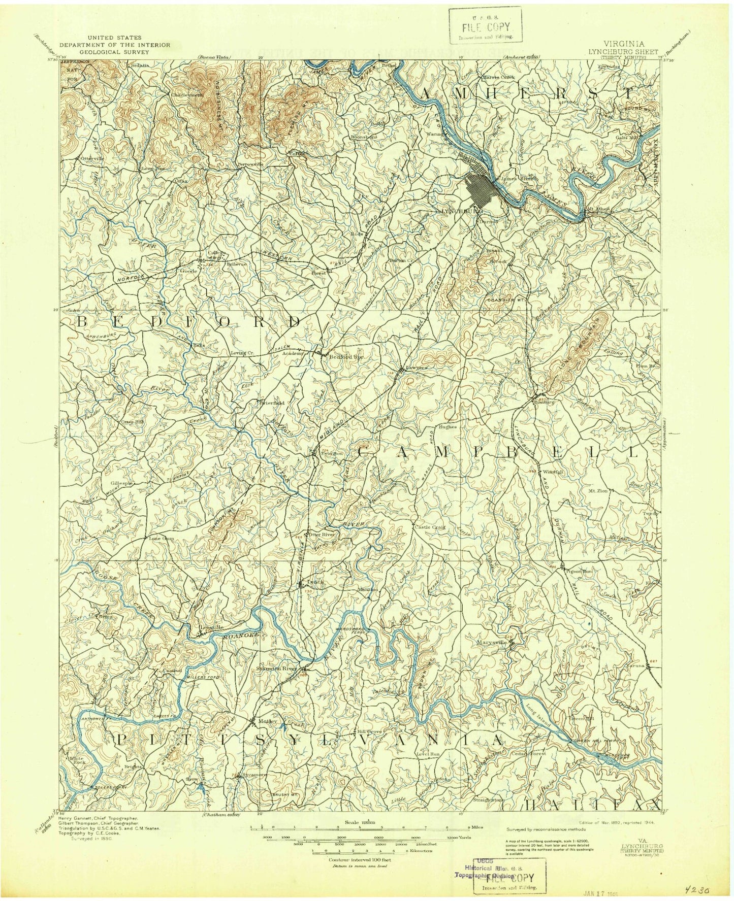
Historic 1892 Lynchburg Virginia 30'x30' Topo Map
Couldn't load pickup availability
Historical USGS topographic map of Lynchburg in the state of Virginia. Scale: 1:125000. Print size: 18" x 24"
This map was published in 1892 and is in the following counties: Amherst, Appomattox, Bedford, Campbell, Halifax, Lynchburg (city), Pittsylvania.
The map contains contour lines, roads, rivers, towns, streams, and lakes. Printed on high-quality waterproof paper with UV fade-resistant inks.
Contains the following named places: Altavista, American Legion Lake, Amos Branch, Archer Creek, Mount Athos, Back Creek, Bear Camp, Beaver Creek, Beck Creek, Beechtree Creek, Bishop Creek, Bob Branch, Bold Branch, Brown Mountain, Buck Branch, Buck Branch, Buffalo Branch, Buffalo Creek, Buffalo Creek, Bull Creek, Bunker Hill Creek, Burks Creek, Buttermilk Creek, Buttom Creek, Buzzard Islands, Camp Hydaway, Camp Ruthers, Camp Sacajqwea, Carter Mill Creek, Carters Creek, Castle Craig, Catamount Creek, Cedar Branch, Cheese Creek, Cherry Creek, Chestnut Island, Chestnut Mountain, Chilarna Lake, Church Campground, Civitan Park, Clay Branch, Cliff Creek, Cobbs Creek, Coles Quarter, Cove Creek, Crab Orchard Creek, Daniel Island, Dry Mountain, Dry Mountain Creek, Dutchman Branch, Eagle Eyrie Virginia Baptist Assembly, East Little Seneca Creek, Elk Creek, Falling Creek, Feagans Island, Flat Creek, Fleming Mountain, Flintstone Creek, Galloway Creek, Glader Branch, Gladys, Goat Island, Goose Creek, Graham Creek, Hale Islands, Harris Creek, Hills Creek, Hillsman Corner, Hodges, Howell Creek, Hurt, Island Branch, Island Creek, Jasper Creek, Jobes Branch, Johns Creek, Johnson Creek, Johnson Mountain, Jones Branch, Joshua Creek, Jumping Branch, Juniper Creek, Kemp Creek, Leesville Lake, Lick Run, Little Beaver Creek, Little Straightstone Creek, Little Sycamore Creek, Little Whipping Creek, Lone Jack Station, Long Branch, Long Branch, Long Branch, Long Island, Long Mountain, Lynch Creek, Lynch Station, Machine Creek, Mansion, Maple Branch, McDaniels Creek, Mead Lake, Meadow Branch, Middle Fork Stovall Creek, Mill Creek, Mill Creek, Mink Hollow Branch, Minter Creek, Moon Mountain, Morton Creek, Mount Zion, Mountain View Lake, Muddy Creek, Muddy Run, Myers Creek, Naruna, New London, Nininger Creek, North Fork Stovall Creek, Oak Mountain Branch, Old Womans Creek, Opossum Creek, Orrix Creek, Otter River, Pigg River, Pittsylvania Wayside Park, Plum Branch, Plum Tree Branch, Pocket Creek, Poorhouse Creek, Poplar Springs Branch, Preston Millpond, Pretty Creek, Reed Creek, Roach Branch, Rockdale Lake, Rocky Branch, Rocky Branch, Rocky Mountain, Rorer Creek, Rough Creek, Round Mountain, Schrader Lake, Seminole Lake, Seneca Creek, Wright Shop, Yellow Branch, Yellow Branch, Skinnels Creek, Slippery Branch, Slush Branch, Smith Branch, South Fork Stovall Creek, Stony Creek, Stony Fork, Straightstone Creek, Swan Creek, Sycamore Creek, Tardy Branch, Taylor Lake, Terrapin Creek, Tinsley Creek, Treasure Island, Troublesome Creek, Tussocky Creek, Valentine Creek, Waltons Store, Wells Creek, West Little Seneca Creek, Wheeler Cliff, Widemouth Creek, Williams Run, Willow Lake, Wooding Branch, Woodruff Island, Woody Lake, Brights, Brutus, Cedar Forest, City Gomingo, Clay, Coffee, Diamond Hill, Gillespie, Grit, Huddleston, Joshua Falls, Level Run, Mentow, Norwood, Perrowville, Seneca, Six Mile, Three Forks, Winesap, Winfall, Woodford Corner, Blackwater Creek, Burton Creek, Candler Mountain, Cheese Creek, Dreaming Creek, Fishing Creek, Fort Hill Village Shopping Center, Happyland Lake, Ivy Creek, Joes Branch, Johns Creek, Judith Creek, Little Opossum Creek, Lynchburg, Miller Park, Pigeon Creek, Pittman Plaza, Rivermont, Riverside Park, Tomahawk Creek, Bedford Lake, Big Otter River, Boyles Branch, Centerville, Charlemont, Chestnut Branch, Coltons Mill, Curtis, Grassy Mountain, Gunstock Creek, Hurricane Creek, Hurricane Mountain, Jackson Mountain, Lillies Branch, Little Otter River, Lone Pine, Lone Pine Mountain, Nelson Creek, North Otter Creek