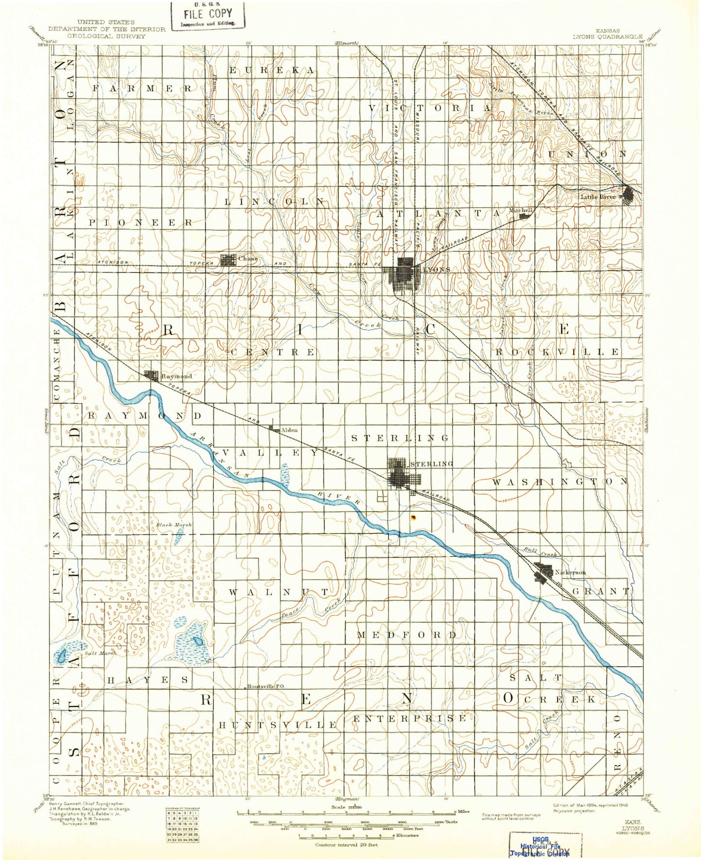
MyTopo
Historic 1894 Lyons Kansas 30'x30' Topo Map
Couldn't load pickup availability
Historical USGS topographic map of Lyons in the state of Kansas. Scale: 1:125000. Print size: 17" x 24"
This map was published in 1894 and is in the following counties: Barton, Reno, Rice, Stafford.
The map contains contour lines, roads, rivers, towns, streams, and lakes. Printed on high-quality waterproof paper with UV fade-resistant inks.
Contains the following named places: Township of Huntsville, Township of Hayes, Township of Enterprise, Sugar Creek, Township of Salt Creek, Township of Farmer, Plum Creek, Calf Creek, Lost Creek, Township of Eureka, Frederick Oil Field, Township of Victoria, Township of Galt, Horse Creek, Little Cheyenne Creek, Township of Pioneer, Chase-Silica Oil Field, IXL Oil Field, Calf Creek Oil Field, Ringwald Oil Field, Mary Ida Oil Field, Orth West Oil Field, Orth Oil Field, Township of Lincoln, Township of Harrison, Lyons West Oil and Gas Field, Township of Mitchell, Kepley Oil Field, Owl Creek, Little Cow Creek, Mitchell, Jarvis Creek, Little River, Odessa Oil Field, Crawford Oil Field, Township of Raymond, Township of Bell, Raymond, Spring Creek, Township of Sterling, Township of Valley, Township of Atlanta, Township of Center, Tobias Northwest Oil Field, Tobias Oil Field, Wayside Park, Chase, Township of Wilson, Township of West Washington, Salt Creek, Camp Wa-Ja-To, West Park, Shumway Oil Field, Lyons, Saxman, Wherry Oil Field, Santa Fe Slough, Dry Creek, Salt Creek, Lake Darrynane, Park Smith Lake, Dead Horse Slough, Township of Medford, Township of Walnut, Peace Creek, Wisby Oil Field, Fritzpatrick Gas Field, Rino Oil Field, Alden Gas Storage Field, Alden, Township of Grant, Sterling Oil Field, Sterling Southwest Oil Field, Bull Creek Oil Field, Dymond Oil Field, Sterling, Dry Creek, Bull Creek, Nickerson, Little Salt Marsh, Horseshoe Lake, Slough Creek, Lake Darrynane Dam, Spriggs Rock Lake, Little River Dam, Huntsville, Grand Shopping Center, State of Kansas, Pollard, Galt, Silica, Kilbourns Corner, McVays Corner, Charters Corner, Yaggy, Adams Corner, Whiteside, Rice County, City of Lyons, City of Nickerson, City of Sterling, City of Chase, City of Alden, City of Little River, City of Raymond, Alden Wastewater Plant, Sterling Wastewater Plant, Chase Sewer Treatment Plant, Lyons Industrial Park, Sterling Municipal Power Plant, Lyons Wastewater Treatment Facility, Raymond Wastewater Plant, Sunview Mobile Home Park, Western Acres Mobile Home Park, Sterling Country Club, Chase Golf Course, Lyons Town and Country Club, Paradise Pastures Golf Course, Agchoice - Emporia Grain Elevator Number 1, Silica Grain Elevator Number 1, Team Marketing Alliance Grain Elevator Number 30, Team Marketing Alliance Grain Elevator Number 36, Team Marketing Alliance Grain Elevator Number 47, Diamond U Stock Farm, Sieker Farms, Delta Egg Farm