MyTopo
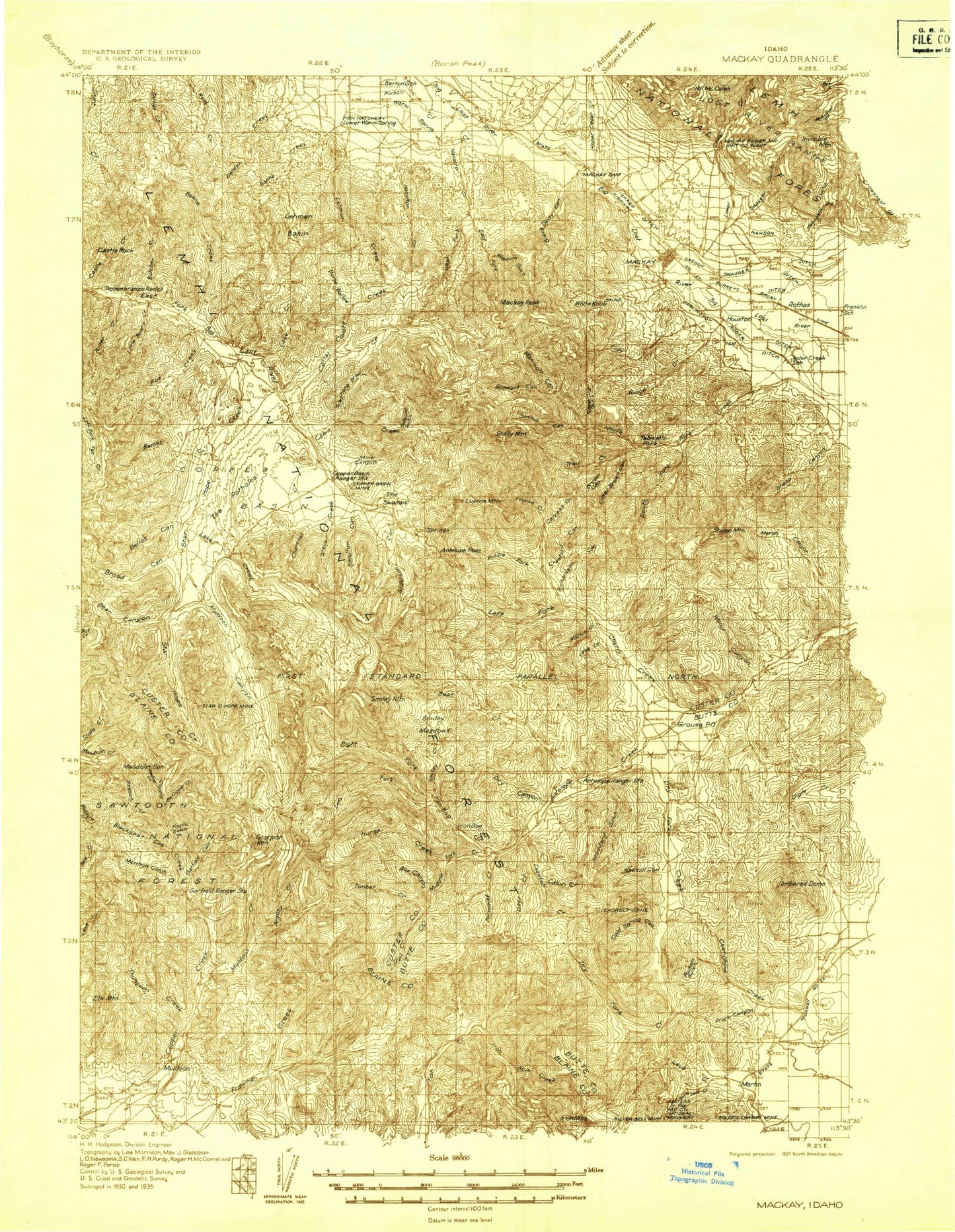
Historic 1935 MacKay Idaho 30'x30' Topo Map
Couldn't load pickup availability
Historical USGS topographic map of MacKay in the state of Idaho. Scale: 1:96000. Print size: 24" x 27"
This map was published in 1935 and is in the following counties: Blaine, Butte, Custer.
The map contains contour lines, roads, rivers, towns, streams, and lakes. Printed on high-quality waterproof paper with UV fade-resistant inks.
Contains the following named places: Black Cap Peak, Chicken Creek, East Fork Boone Creek, Graveyard Canyon, Latham Hollow, Mountain Spring Canyon, Ras Canyon, Schoolhouse Canyon, Smiley Meadows, Trail Creek, Waddoups Canyon, Alder Creek, Anderson Canyon, Antelope Guard Station, Antelope Pass, Antelope Valley, Argosy Creek, Bailey Corral Canyon, Dry Canyon, Bear Canyon, Bear Creek, Bear Creek Lake, Bedy Canyon, Bell Rock, Bellas Canyon, Bellas Lakes, Big Black Dome, Big Blind Canyon, Big Canyon, Big Lake, Black Cap, Black Daisy Canyon, Blackspar Canyon, Blaze Canyon, Blind Canyon, Blizzard Basin, Blue Rock, Boundary Gulch, Box Bailey Corral Canyon, Broad Canyon, Brockie Lake, Brockie Ranch, Buck Canyon, Bullion Gulch, Burnt Hollow, Butcher Creek, Cabin Creek, Cabin Creek, Cabin Mountain, Camp Creek, Cape Horn Draw, Carcass Creek, Castle Creek, Castle Rock, Cave Rock, Champion Mine, Charcoal Creek, Cherry Creek, Chicken Canyon, Chimney Gulch, Clear Lake, Cliff Creek, Coal Creek, Cold Spring Canyon, Copper Basin, Copper Basin Cow Camp, Copper Basin Flat, Copper Basin Guard Station, Copper Basin Knob, Copper Basin Mine, Copper Creek, Copper Creek Camp, Copper Creek Trail, Corral Creek, Corral Creek Cow Camp, Cossack Tunnel, Cougar Gulch, Coyote Canyon, Coyote Creek, Crawford Canyon, Darlington Ditch, Darlington Shaft, Deadman Creek, Death Canyon, Deep Gulch, Deer Creek, Drummond Mine, Dry Canyon, Dry Hollow, Dry Hollow, Eagle Bird Mine, East Fork Lehman Creek, East Fork Navarre Creek, Elk Mountain, Ella Mine, Empire Mine, Empire Smelter, Fishpole Lake, Fox Canyon, Fox Creek, Frisco Gulch, Garden Creek, Garfield Canyon, Golden Chariot Mine, Golden Lake, Grasshopper Creek, Green Lake, Hamilton Creek, Hanson Ditch, Hooley Creek, Horse Wallow, Horseshoe Canyon, Horseshoe Mine, Horsethief Creek, Howell Canyon, Hub Mine, Hurst Canyon, Idaho Muldoon Mine, Iron Bog Creek, Iron Bog Lake, Iron Bog, Iron Mine Creek, Kerf Creek, Lake Creek, Lake Creek, Lake Creek, Larkspur Canyon, Last Chance Mine, Lava Creek, Leadbelt Creek, Left Fork Bear Creek, Left Fork Cherry Creek, Left Fork Death Canyon, Left Fork Iron Bog Creek, Left Fork Waddoups Canyon, Lehman Basin, Lehman Butte, Lehman Creek, Lime Mountain, Little Blind Canyon, Little Boone Creek, Little Copper Creek, Little Rough Canyon, Little Thompson Creek, Logan Tunnel, Lone Pine Creek, Long Canyon, Long Lake, Lower Brown Canyon, Lower Cedar Creek, Lower Cedar Creek Ditch, Lupine Mountain, Mackay Dam, Mackay Peak, Mackay Reservoir, Mahogany Gulch, Mammoth Canyon, Marcroft Canyon, Marsh Canyon, Martins Ditch, Mount McCaleb, Middle Fork Bear Creek, Middle Fork Cherry Creek, Middle Fork Navarre Creek, Middle Mountain, Miller Peak, Mine Canyon, Morman Gulch, Mormon Hill, Mud Lake, Muldoon, Muldoon Canyon, Muldoon Mine, Muldoon Ridge, Mutual Gulch, Mutual Mine, Navarre Creek, North Fork Little Copper Creek, Oxide Lode Mine, Parsons Creek, Payne Creek, Pete Creek, Pine Creek, Poison Creek, Poison Gulch, Pole Stackyard Creek, Price Canyon, Price Canyon, Pyramid Peak, Ramey Creek, Rawson Creek, Redbird Gulch, Redbird Mountain, Reliance Mine, Reserve Mountain, Richardson Canyon, Rider Creek, Right Fork Bear Creek, Right Fork Death Canyon, Right Fork Iron Bog Creek, Right Fork Sawmill Canyon, Right Fork Waddoups Canyon, Right Fork Willow Creek, Rio Grande Canyon, Road Creek, Rocky Bar, Rosenkranze Ranch, Rough Canyon, Rough Canyon, Rough Lake, Round Lake, Round Lake, Round Mountain, Saint Louis Canyon, Saint Louis Mine, Sawmill Canyon, Sharp Ditch, Sheep Canyon, Sheep Mountain, Shelly Mountain, Silver Bell Mine, Slaughterhouse Canyon, Slim Creek, Smelter Canyon, Smiley Creek, South Fork Alder Creek, South Fork Little Copper Creek, South Lava Creek, Spring Creek, Star Hope Campground, Star Hope Creek, Star Hope Gulch, Star Hope Mine, Steve Creek, Stewart Canyon, Stoddard Gulch