MyTopo
Historic 1891 Manchester Kentucky 30'x30' Topo Map
Couldn't load pickup availability
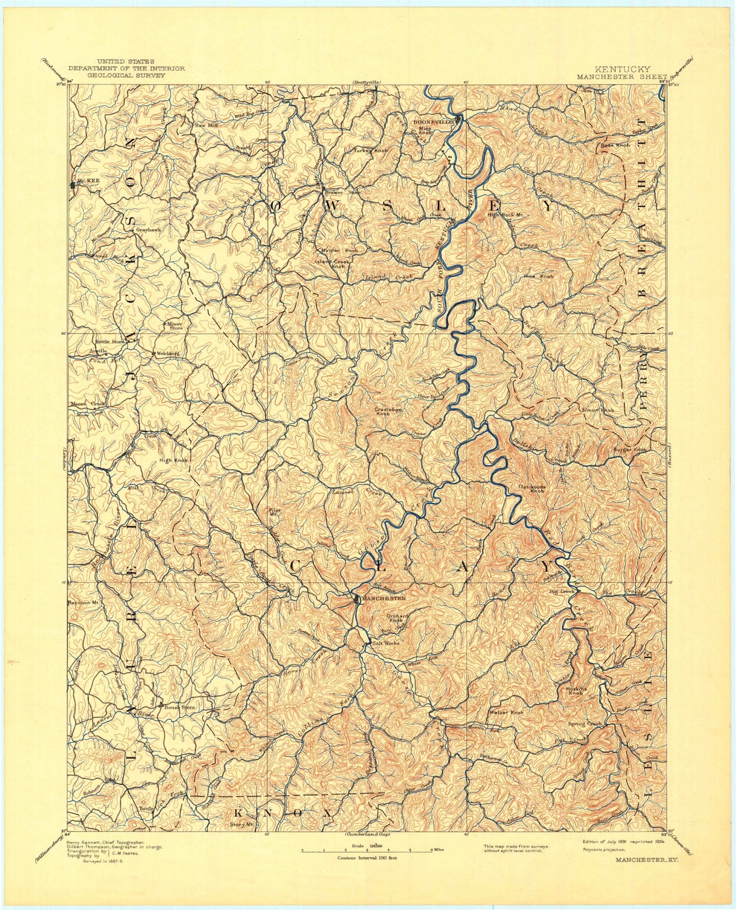
Historical USGS topographic map of Manchester in the state of Kentucky. Scale: 1:125000. Print size: 18" x 24"
This map was published in 1891 and is in the following counties: Breathitt, Clay, Jackson, Knox, Laurel, Lee, Leslie, Owsley, Perry.
The map contains contour lines, roads, rivers, towns, streams, and lakes. Printed on high-quality waterproof paper with UV fade-resistant inks.
Contains the following named places: Polly Marcum Branch, Aaron Branch, Alderson Branch, Alger, Amis Branch, Ammie, Amy Branch, Anglin Creek, Annville, Antony Branch, Arnett, Arnetts Fork, Asher Knob, Ashers Fork, Ashers Fork, Atkinstown, Baileys Branch, Baker Branch, Baker Creek, Bald Head Hollow, Baldwin Branch, Balls Branch, Banks Branch, Barbecue Branch, Barcreek, Barger Branch, Barger Branch, Barn Branch, Barn Hollow, Beals Fork, Bear Branch, Bear Branch, Bear Creek, Bear Gap Branch, Bear Run, Beatty Fork, Becky Hollow, Bee Branch, Bee Branch, Beech Creek, Beech Fork, Belles Fork, Benge, Bennets Branch, Bernice, Betty Bowman Creek, Betty Thomas Branch, Big Branch, Big Branch, Big Branch, Big Branch, Big Branch, Big Branch, Big Briar Branch, Big Buck Lick, Big Creek, Big Creek, Big Dan Branch, Big Double Creek, Big Graveyard Hollow, Big Johns Branch, Big Middle Fork Elisha Creek, Big Paul Bailey Branch, Big Rooster Branch, Big Twin Creek, Bill Oak Branch, Billies Branch, Bills Branch, Billy Branch, Billys Branch, Black Pool Hollow, Blackie Branch, Blackwater, Blackwater Creek, Blackwater Creek, Blake, Blaze Hollow, Blevins Branch, Blue John Hollow, Bluehole, Blythe Branch, Bobs Fork, Bond, Boones Branch, Booneville, Boots Branch, Botto, Bowen Creek, Bowling Branch, Bradshaw, Bray Creek, Brewer Fork, Bridge Branch, Brier Branch, Brier Hollow Gap, Brightshade, Britton Branch, Britton Branch, Brock, Broker Branch, Broughton Branch, Brushy Creek, Brushy Ridge, Brutus, Buck Branch, Buck Creek, Buck Fork, Buckeye Branch, Buffalo Branch, Buffalo Creek, Bug Hollow, Bull Hollow Branch, Bullskin Branch, Bullskin Creek, Bunches Branch, Buncomb Creek, Bungeon Branch, Burger Branch, Burning Springs, Burning Springs Fork, Burnt House Branch, Burton Fork, Bush, Brushy Branch, Buzzard Creek, Cabin Branch, Camp Branch, Camp Branch, Cane Branch, Cane Creek, Cane Creek, Caney Branch, Caney Branch, Caney Knob, Carpenter Branch, Cave Branch, Cave Branch, Chandler Branch, Chandler Branch, Chap Branch, Cherry Tree Branch, Chestnut Branch, Chestnut Gap, Chestnut Gap Branch, Chestnutburg, Chicken Branch, Chicken Branch, Chop Bottom Branch, Clay Gap, Clover Hollow, Coal Hollow, Coal Hollow, Cob Branch, Cold Spring Branch, Collins Branch, Collins Fork, Collins Fork, Collins Fork, Conkling, Cool Branch, Cool Springs Branch, Copperhead Hollow, Cortland Fork, Cotton Gap, Cottongim, Couch Fork, Court House Branch, Cow Creek, Cowcreek, Cradlebow Branch, Crane Branch, Crane Creek, Crane Creek, Crane Fork, Crawfish Branch, Crawford, Creekville, Crib Branch, Curry Branch, Cutoff Knob, Cutoff Mountain, Dalesburg, Danger Branch, Daniel Branch, Dark Hollow, Datha, Davidson Branch, Davis Branch, DeZarns Fork, Deadening Hollow, Deep Gap, Deer Lick, Deer Lick Branch, Deerlick Branch, Devils Den Branch, Dillion Branch, Dimpson Hollow, Disappointment Creek, Dixon Branch, Doar Branch, Dog Gap, Doorway, Downey Branch, Drench Branch, Drowned Branch, Drum Branch, Dry Branch, Dry Branch, Dry Branch, Dry Fork, Dry Fork, Dusty Fork, Earnestville, East Fork Pigeon Roost Branch, Eds Lick, Egypt, Elder Lick Branch, Eli Branch, Elias, Elisha Creek, Elk Creek, Elk Gap, Ells Branch, Elsam Fork, Endee, Engine Branch, Enoch Fork, Ephram Branch, Eriline, Eversole, Fall Rock, Falling Timber Branch, Felty, Felty Gap, Fields Branch, Fish Creek