MyTopo
Historic 1894 Mankato Kansas 30'x30' Topo Map
Couldn't load pickup availability
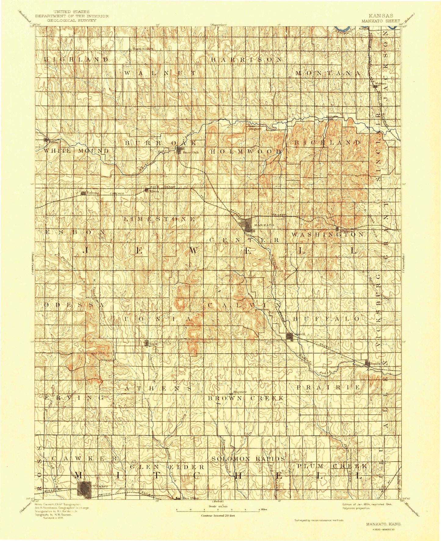
Historical USGS topographic map of Mankato in the state of Kansas. Scale: 1:125000. Print size: 17" x 24"
This map was published in 1894 and is in the following counties: Jewell, Mitchell, Osborne.
The map contains contour lines, roads, rivers, towns, streams, and lakes. Printed on high-quality waterproof paper with UV fade-resistant inks.
Contains the following named places: North Branch White Rock Creek, Township of Highland, Township of White Mound, Township of Walnut, Township of Burr Oak, Burr Oak Creek, Walnut Creek, Ash Creek, Antelope Creek, Township of Harrison, Wolf Creek, Long Branch, Township of Holmwood, Burr Oak, Porcupine Creek, Lovewell Reservoir, Township of Montana, Township of Richland, Spring Creek, Troublesome Creek, Korb Creek, Norway Creek, Taylor Creek, Lovewell State Park, Cedar Point Recreation Area, Oak Hill Recreation Area, Johns Creek, Webber, Montana Creek, Porcupine Creek, Township of Limestone, West Limestone Creek, Middle Limestone Creek, Smith Creek, Westside Community Center, Esbon, Township of Center, Elm Creek, Township of Washington, Middle Buffalo Creek, East Fork Big Timber Creek, East Union Community Hall, Mankato, East Buffalo Creek, Montrose, Township of Odessa, Township of Erving, Township of Ionia, Township of Athens, Little Oak Creek, Ionia, Jewell County State Park, Ash Creek, Township of Browns Creek, Township of Calvin, West Buffalo Creek, Dry Creek, Jewell, Township of Prairie, Township of Buffalo, Prairie Creek, Spring Creek, Randall, Township of Cawker, Township of Glen Elder, Cawker City, Disappointment Creek, Spring Branch, Township of Solomon Rapids, Township of Plum Creek, Lovewell Wildlife Area, Glen Elder State Park, Lovewell Dam, Jewell County State Lake, Jewell County State Lake Dam, Jewell County Dam, Blue Hills Upland, Hermes Creek, Northbranch, Big Timber Creek, Wesley Center, Otego, Dentonia, Salem, Jewell County, Township of Esbon, City of Burr Oak, City of Cawker City, City of Esbon, City of Glen Elder, City of Jewell, City of Mankato, City of Randall, City of Webber, Glen Elder State Park Arikaree Campground, Glen Elder State Park Cheyenne Campground, Glen Elder State Park Kanza Campground, Glen Elder State Park Kaw Campground, Glen Elder State Park Kiowa Campground, Glen Elder State Park Osage Campground, Glen Elder State Park Sioux Campground, Glen Elder State Park Uskuts Campground, Lovewell State Park Cedar Point Campground, Lovewell State Park Cottonwood Campground, Lovewell State Park Pioneer Campground, Lovewell State Park Walleye Point Campground, Lovewell State Park Willow Campground, Mankato Municipal Wastewater Treatment Plant, Burr Oak Wastewater Plant, Esbon Wastewater Plant, Jewell Wastewater Plant, Randall Wastewater Plant, Lakeside Golf Course, Jewell County Fairgrounds, Agmark Grain Elevator Number 4, Agmark Grain Elevator Number 10, Agmark Grain Elevator Number 15, Esbon Grain and Fertilizer Grain Elevator Number 1, Esbon Grain and Fertilizer Grain Elevator Number 2, Midway Co - Operative Association Grain Elevator Number 5