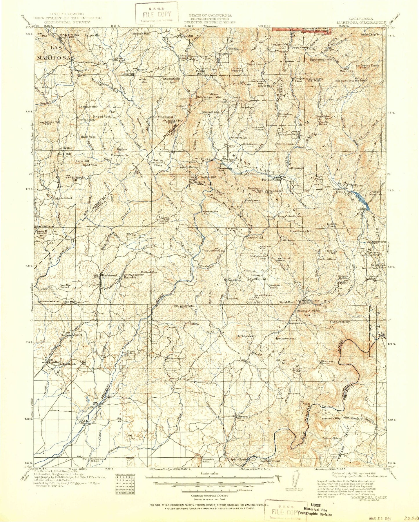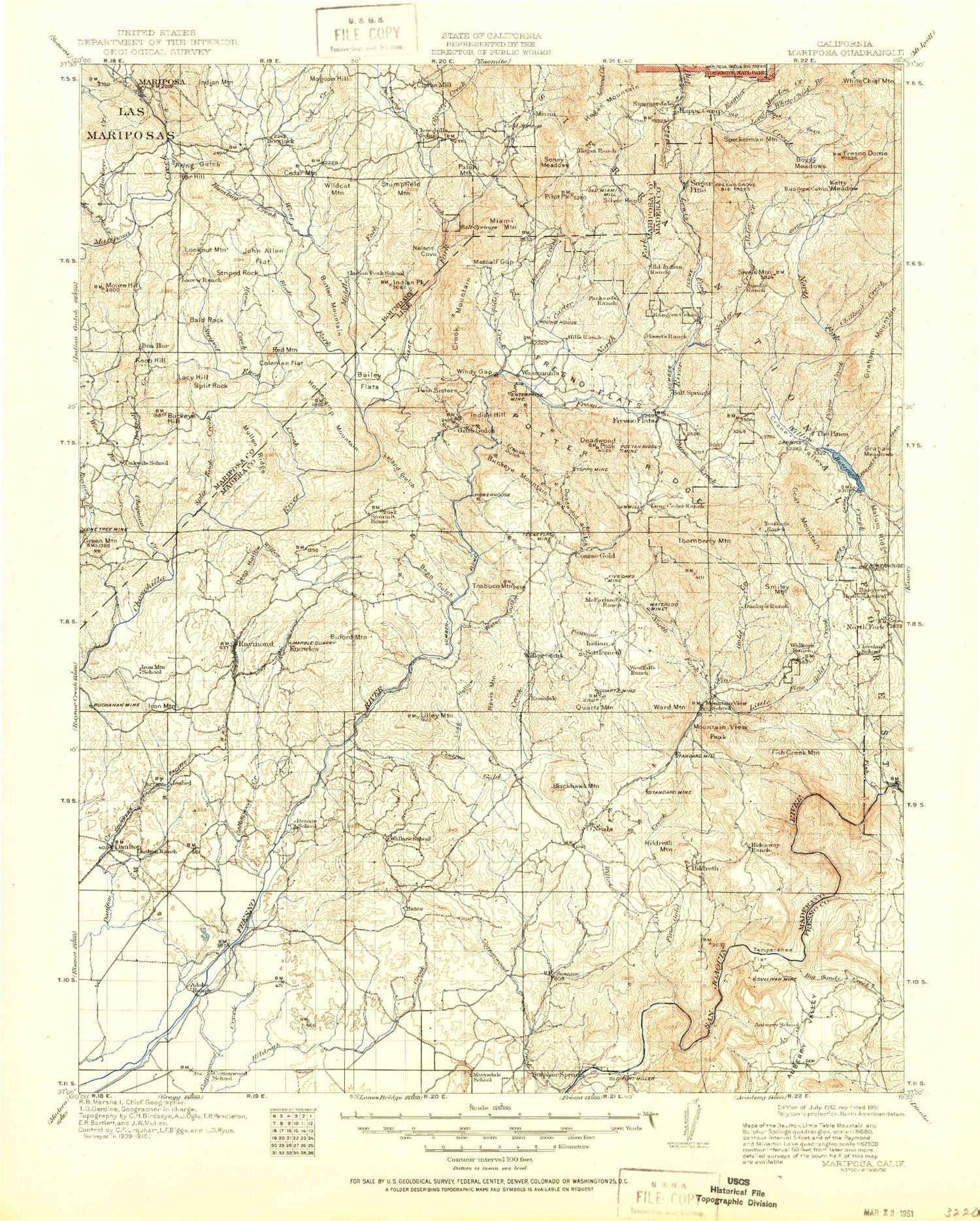
MyTopo
Historic 1912 Mariposa California 30'x30' Topo Map
Couldn't load pickup availability
Historical USGS topographic map of Mariposa in the state of California. Scale: 1:125000. Print size: 17" x 24"
This map was published in 1912 and is in the following counties: Fresno, Madera, Mariposa.
The map contains contour lines, roads, rivers, towns, streams, and lakes. Printed on high-quality waterproof paper with UV fade-resistant inks.
Contains the following named places: Adkins Mountain, Adobe Hill, Adobe Ranch, Ashbrook Creek, Bailey Flats, Bald Rock, Bates Station, Bean Gulch, Becknell Creek, Bellview, Berry Hill, Big Bend, Boggy Meadow, Buchanan Mine, Buckeye Creek, Buckeye Hill, Buffin Meadow, Buzzard Canyon, Chapman Creek, China Garden, China Slough, Chipmunk Meadow, Coleman Flat, Cow Creek, Daulton Mine, Davis Ranch, De Long Creek, Deep Hollow, Douglas Ranch, Fresno Flats, Friant Dam, Gooseberry Flat, Granite King Mine, Green Mountain, Grub Gulch, Happy Hollow, Horse Creek, Horsecamp Mountain, Hulbert Mountain, Humbug Creek, Indian Peak, Iron Mountain, Italian Creek, J McDougal Ranch, Jesse Belle Shaft, John Allen Flat, Knob Hill, Kramer Meadow, Lacy Hill, Leland Gulch, Little Table Mountain, Long Hollow, Long Meadow, Lookout Mountain, Madera Canal, Madera Equalization Reservoir, Madera Lake, Madera Quarry, Mariposa Mine, Metcalf Gap, Millerton Ridge, Moore Hill, Mullen Ridge, N McDougal Ranch, Nelson Cove, North Branch Willow Creek, North Shaft, O'Neal Ranch, Owl Creek, Pincushion Mountain, Poison Meadow, Rabbit Hill, Rawls Gulch, Raymond Quarry, Red Mountain, Red Top Lookout, Rosati Shaft, Shaubach Ranch, Sivels Mountain, Agua Fria Creek, Bigelow Ranch, Blackhawk Mountain, Butler Mountain, Camp Meeting Creek, Coarse Gold Fire Station, Fox Creek, House Ranch, Jones Creek, Kelshaw Corners, Ladd Creek, Lewis Ranch, Madera Lake Park and Recreational Area, Magoon Creek, Mercer Mountain, Mud Spring Creek, O'Neals, Oliver Creek, Picayune Creek, Quartz Mine, Quartz Mountain, Rosedale Ranch, San Joaquin Experimental Range, Soquel Meadow Ranch, Spangle Gold Creek, Spinecup Ridge, Split Rock Creek, Spring Creek, Striped Rock, Striped Rock Creek, Stumpfield Mountain, Summit House, The Forks, Tick-Tack-Toe Hill, Twentytwo Mile House, Twin Sisters, United States Forest Service Headquarters, Urrutia Ranch, Veater Ranch, Ward Mountain, Water Gulch, Whisky Creek, White Chief Mountain, Wide Awake Ranch, Wild Hog Canyon, Wildcat Creek, Wildcat Mountain, Willow Creek, Willow Creek, Willow Creek, Winchell Bay, Windy Gap, Zebra Station, Snow Creek, Marshall Station, Fresno Dome, Corlieu Falls, Goat Meadow, Greys Mountain, Kelty Meadow, Red Rock Falls, Angle Falls, Bass Lake Annex, Browns Creek Ditch, Devils Slide, Meserve Meadow, Number Three Ditch, Number Three Forbay Penstock, Old Corral, Salter Creek, Slick Rock, Willow Cove, Daulton, Elliott Corner, Fresno Crossing, Knowles Junction, Cedar Valley, Greys Mountain Campground, Kelty Meadow Campground, Texas Flat Group Campground, Cedarbrook, Harris Ranch Mill, Worman Mill, Yosemite Mountain Sugar Pine Historical Railroad, Wassama Round House State Historic Park, Bass Lake Station, Bass Lake Vista, Beaver Ponds, Crane Valley Campground, Falls Beach Picnic Area, Little Denver Church Campground, Recreation Point, Sheriffs Tower, Willow Cove Picnic Area, Wishon Point Boat Launch, Big Sandy Campground, California Creek, China Creek, Crooks Mountain, Fresno Dome Campground, Grouse Meadow, Hoggem Lake, Hole Ranch, Little Sandy Campground, Long Meadow Creek, Nelder Grove Campground, Rainier Creek, Sivels Ranch, Coarse Gold Creek, Fine Gold Creek, Soquel Campground, Soquel Meadow, White Chief Branch, Daulton Creek, Ahwahnee, Auberry Valley, Bald Rock, Bass Lake, Big Sandy Creek, Big Sandy Valley, Blade Creek, Buckeye Mountain, Burford, Carter Creek, Chepo Saddle, Chilkoot Campground, Chilkoot Creek, China Wells, Coarsegold, Cold Spring Meadow, Corlew Mountain, Crook Mountain, Deadwood Gulch, Deadwood Peak, Denver Church Campground, East Fork Chowchilla River, Enterprise Mine, Fish Camp, Forks Campground, French Gulch, Graham Meadow, Graham Mountain, Happy Camp, Hawkeye Mine, Hewitt Valley, Hideaway Ranch, Hildreth Mountain, Hogan Mountain, Hurley Fire Control Station, Kennedy Table, Lewis Fork, Lily Mine, Little Sandy Creek, Lone Sequoia Campground, Lupine-Cedar Bluffs Campground, Marshall Hill, Marshall Junction