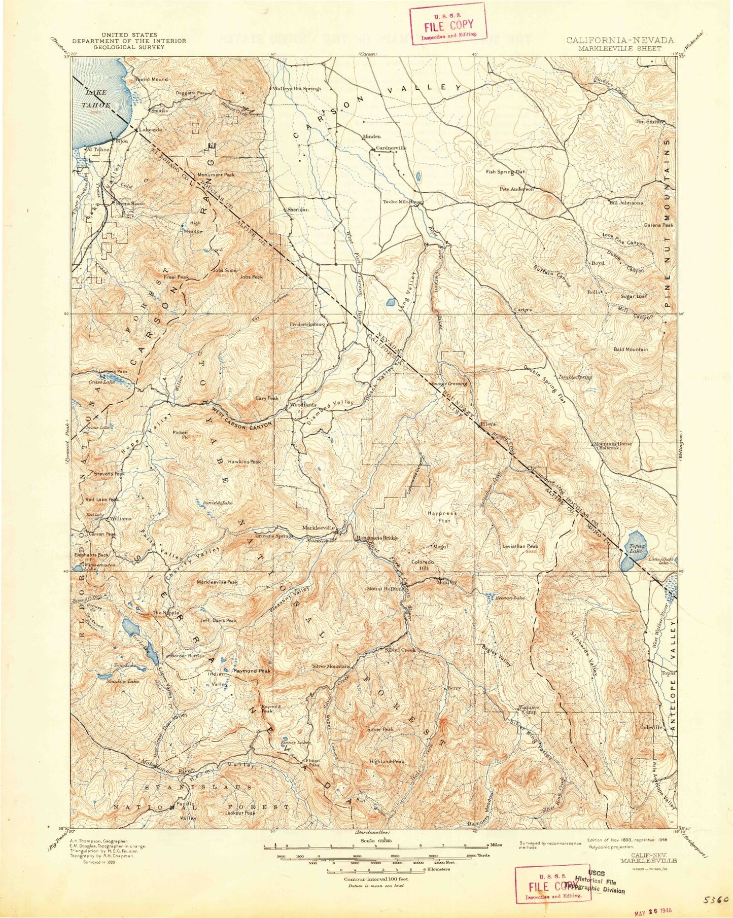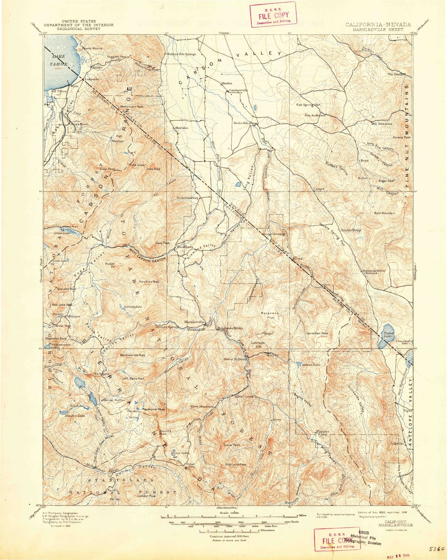
MyTopo
Historic 1893 Markleeville California 30'x30' Topo Map
Couldn't load pickup availability
Historical USGS topographic map of Markleeville in the state of California. Scale: 1:125000. Print size: 17" x 24"
This map was published in 1893 and is in the following counties: Alpine, Douglas, El Dorado, Mono.
The map contains contour lines, roads, rivers, towns, streams, and lakes. Printed on high-quality waterproof paper with UV fade-resistant inks.
Contains the following named places: Acorn Canyon, Bagley Valley, Black Dome, Bryant Creek, Bull Canyon, California Creek, Cary Canyon, Cary Peak, Lake Christopher, Cliff Meadow, Cold Creek, Company Meadows, Crystal Springs Campground, Diamond Valley, Diamond Valley Ditch, Dixon Creek, Dome Two, Dry Canyon, Dumonts Meadows, Dump Canyon, East Slough, El Dorado Beach, El Dorado County Campground, Fay Canyon, Fredericksburg Canyon, Heavenly Valley, Heavenly Valley Creek, Hidden Canyon, High Meadows, Highland Peak, Horsethief Canyon, Jobs Peak, Jones Canyon, Larson Canyon, Leviathan Peak, Lexington Canyon, Luther Creek, Merk Canyon, Millich Ditch, Monitor Pass, Monument Peak, Poison Creek, Railroad Canyon, Saxon Creek, Scossa Canyon, Scott Creek, Shingle Mill Flat, Sierra House, Silver King Creek, Slinkard Valley, Cloudburst Canyon, Deep Canyon, Indian Creek Reservoir, Poison Flat, Silver King Valley, Slinkard Creek, Snowshoe Thompson Historical Mon, Snowslide Canyon, Star Lake, Stevens Lake, Stuard Canyon, Trout Creek, Truckee Marsh, Upper Truckee River, Vaquero Camp, Voight Canyon, Wade Canyon, Wade Valley, West Carson Canyon, West Fork Carson River, Wiley Ditch, Wolf Creek, Wolf Creek Lake, Wolf Creek Meadow, Topaz, Trimmer Peak, Snowshoe Thompson Ditch Number Two, Acacia Mine, Adolphus Canyon, Alhambra Mine, Alkali Ditch, Alpine Mine, Armstrong Pass, Asa Lake, Avalanche Meadow, Barney Riley, Barney Riley Creek, Beaver Meadow, Bloomfield Campground, Bloomfield Meadow, Blue Creek, Border Ruffian Flat, Bryant Creek, Buck Creek, Bull Lake, Burnside Lake, Burnside Mine, Cache Creek, Cal-Pine Mine, Carson Pass, Centennial Bluff, Centerville Flat, Charity Valley, Charity Valley Creek, Clover Valley, Colorado Hill, Cottonwood Canyon, Crater Lake, Curtz Lake, Curtz Mine, Damsite Campground, Dangberg Camp, Deadwood Lake, Deer Creek, Deer Valley, Devils Corral, Devils Corral Creek, Dorothy Lake, Dry Lake, Eagle Creek, Eagle Gulch, East Fork Carson River, Ebbetts Pass, Elbow Creek, Elephants Back, English Meadow, Evergreen Lake, Excheque Mine, Faith Valley, Forest City Flat, Forestdale Creek, Forestdale Divide, Free Meadows, Freel Peak, Frog Lake, Globe Mine, Golden Gate Mine, Goskey Canyon, Gould and Curry Mine, Granite Lake, Grass Lake, Grouse Creek, Grover Hot Springs State Park, Hangmans Bridge, Hawkins Creek, Hawkins Peak, Haypress Flat, Heenan Creek, Heenan Lake, Hell Hole, Hellhole Lake, Hermit Valley, High Peak, Hope Valley, Hope Valley Campground, Horse Meadow, IXL Canyon, IXL Mine, Indian Creek, Indian Creek, Indian Valley, Isabella Tunnel, Jackson Canyon, Jeff Davis Creek, Da-ek Dow Go-et Mountain, Jobs Sister, Kinney Creek, Kinney Reservoir, Kit Carson, Kit Carson Campground, Lady Franklin Mine, Lady Washington Mine, Leviathan Canyon, Leviathan Creek, Leviathan Mine, Lily Pad Lake, Lincoln Mine, Little Antelope Valley, Little Cottonwood Canyon, Little Indian Valley, Lookout Peak, Loope Canyon, Lost Lakes, Lower Blue Lake, Lower Kinney Lake, Lower Sunset Lake, Luther Pass, Markleeville Creek, Markleeville Peak, Maxwell Creek, Meadow Lake, Middle Creek, Middle Creek Campground, Milk Ranch Meadow, Millberry Canyon, Millberry Creek, Mineral Mountain, Mogul Canyon, Mogul Peak, Mokelumne Wilderness, Monitor Creek, Morningstar Mine, Mosquito Lake, Mountain Mine, Mountaineer Creek, Musser and Jarvis Creek, Napoleon Canyon, Noble Canyon, Noble Lake, Pacific Creek, Pacific Valley, Pennsylvania Creek, Pennsylvania Mine, Pickett Peak, Pleasant Valley, Poison Creek, Poor Boy Creek, Quaking Aspen Campground, Randall Creek, Raymond Canyon Creek, Raymond Lake, Raymond Meadows, Raymond Meadows Creek, Raymond Peak, Red Gap Mine, Red Lake, Red Lake Creek, Red Lake Peak, Reynolds Peak, Rice Lake, Rippon Mine, Rodriguez Flat, Sagehen Flat, Sandy Meadow, Sandy Meadow Creek, Sawmill Creek