MyTopo
Historic 1908 Marsh Peak Utah 30'x30' Topo Map
Couldn't load pickup availability
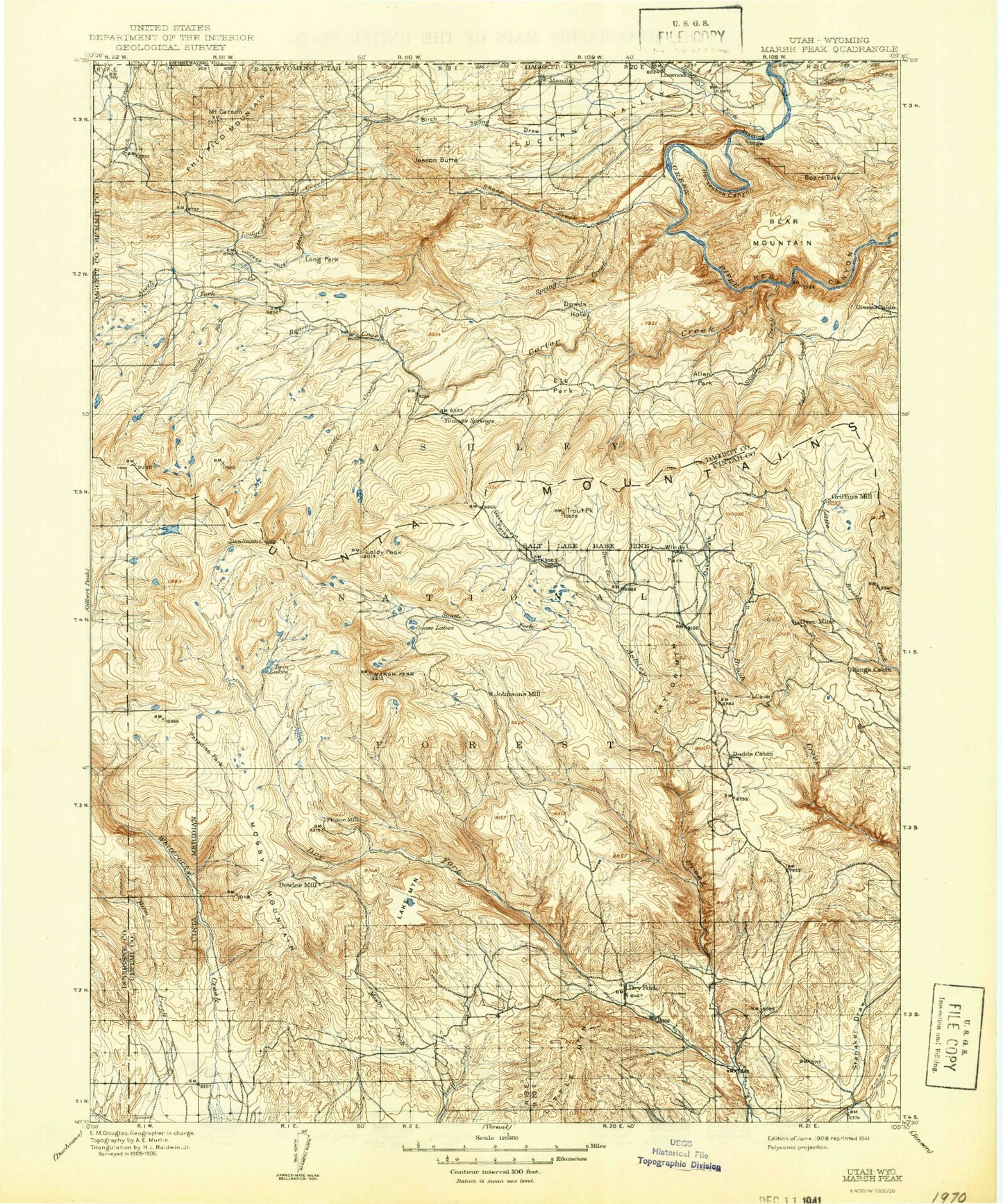
Historical USGS topographic map of Marsh Peak in the state of Utah. Scale: 1:125000. Print size: 17" x 24"
This map was published in 1908 and is in the following counties: Daggett, Duchesne, Sweetwater, Uintah.
The map contains contour lines, roads, rivers, towns, streams, and lakes. Printed on high-quality waterproof paper with UV fade-resistant inks.
Contains the following named places: Big Tom Hollow, Bridger Canyon, Coal Mine Draw, Elkhorn Guard Station, Farm Creek Canal, Horseshoe Canyon, Ice Cave Peak, Lees Hollow, Loggers Cabin Park, Ralphs Canyon, Red Knoll, Red Pine Canyon, The Hole, Whiterocks, Whiterocks Canal, Wooley Lakes, Gooseneck Boat Camp, Dowd Creek, Alcorn Hollow, Alma Taylor Hollow, Alma Taylor Lake, Anderson Creek, Anson Cabin, Anson Lake, Antelope Flat Development, Antelope Hollow, Ashley Gorge, Beaver Creek, Big Lake, Big Park, Big Park, Big Park, Bills Park, Birch Spring Draw, Black Canyon, Blanchett Park, Blue Lake, Boars Tusk, Browne Lake, Brownie Canyon, Brush Creek Canyon Overlook, Brush Park, Buck Draw, Buck Ridge, Bullionville, Burnt Creek, Burton Reservoir, Canyon Rim Campground, Carmel Campground, Carter Creek, Carter Dugway, Castle Cove, Center Creek, Center Fork Eagle Creek, Center Park, Chalk Cliffs, Charleys Park, Chimney Rock Lake, Chokecherry Draw, Cliff Lake, Colton Hollow, Colton Ranger Station, Corral Park, Corson Peak, Cow Hollow, Crow Creek, Cub Creek, Daggett Lake, Davis Hollow, Dead Horse Park, Dead Lake, Deadman Lake, Death of James Meadow, Death Valley Creek, Deep Creek, Deer Park, Digger Basin, Dodds Hollow, Dollar Lake, Dowd Mountain, Dowd Mountain Overlook Picnic Area, Dowds Hole, Dry Fork, Dry Fork, Dry Fork Overlook, Dry Fork Trail, Dyer Mines, Dyer Mountain, Dyer Park, Eagle Basin, Eagle Creek, East Fork Carter Creek, East Fork Deep Creek, East Fork Eagle Creek, Elk Creek, Elk Park, Enchanted Canyon, Finch Draw, Fish Lake, Flaming Gorge Valley, Frenches Park, Galloway Corral, Gompers Canyon, Goose Lakes, Government Creek, Government Park, Grasshopper Flat, Greens Lakes, Greens Lakes Campground, Grouse Creek, Gull Lake, Hacking Lake, Half Moon Park, Hells Kitchen Park, Hen Lee Bench, Henry Olsen Draw, Henrys Fork, Hickerson Park, Hicks Park, Hideout Canyon, Hideout Draw, Hideout Eagle Basin Trail, Hominy Creek, Honslinger Creek, Hope Creek, Hopper Lakes, Horseshoe Park, Horseshoe Park, Icy Hill Dugway, Iron Spring Camp, Jay Point, Jessen Butte, Johnson Lake, Johnson Park, Julius Park, Kaler Hollow, Kibah Lakes, Kingfisher Canyon, Lake Creek, Lake Mountain, Lake Park, Lakeshore Basin, Lamb Lakes, Leidy Peak, Leona Creek, Lightning Park, Lily Lake, Lily Lake Creek, Lily Pad Lake, Linwood Bay, Little Elk Creek, Little Elk Lake, Little Lake, Little Mountain, Little Valley Corral, Little Water Hills, Little Water Mines, Loco Creek, Lodgepole Canal, Lodgepole Creek, Lonesome Park, Lonesome Park, Long Park, Long Park Reservoir, Lost Park, Lost Park, Lucerne Valley, Lucerne Valley Development, Macks Park, Mahogany Draw, Manila, Manila Park, Marsh Peak, Meadow Park, Merkley Park, Mesa, Middle Fork Carter Creek, Middle Fork Sheep Creek, Middle Mountain, Mill Canyon, Mill Park, Mill Pond, Moap Lake, Moenkopi Campground, Mosby Canal, Mosby Creek, Mosby Mountain, Mosby Park, Mosby Sink, Murray Park, Mytoge Lake, North Brownie Creek, North Fork Ashley Creek, North Fork Crow Creek, North Fork Dry Fork, North Fork Sheep Creek, North Skull Creek, Oaks Park, Oaks Park Reservoir, Ox Park, Palisade Campground, Paradise Campground, Paradise Creek, Paradise Guard Station, Paradise Park, Paradise Peak, Pat Carroll Park, Paul Lake, Pearl Lake, Peoples Canal, Phil Pico Mountain, Pine Hollow, Pine Ridge, Pitt Ditch, Potter Lake, Red Belly Lake, Red Canyon Overlook, Red Canyon Picnic Area, Red Lake, Red Mountain, Red Pine Creek, Reynolds Creek, Roaring Fork, Rock Canyon, Rock Point Canal, Round Park, Sand Lake, Saucer Lake, Sawtooth Ridge, Scraper Spring Draw, Sheep Creek, Sheep Creek Canal, Sheep Creek Gap, Sheep Creek Hill, Sheep Creek Lake, Sheep Creek Park