MyTopo
Historic 1890 Marshall Missouri 30'x30' Topo Map
Couldn't load pickup availability
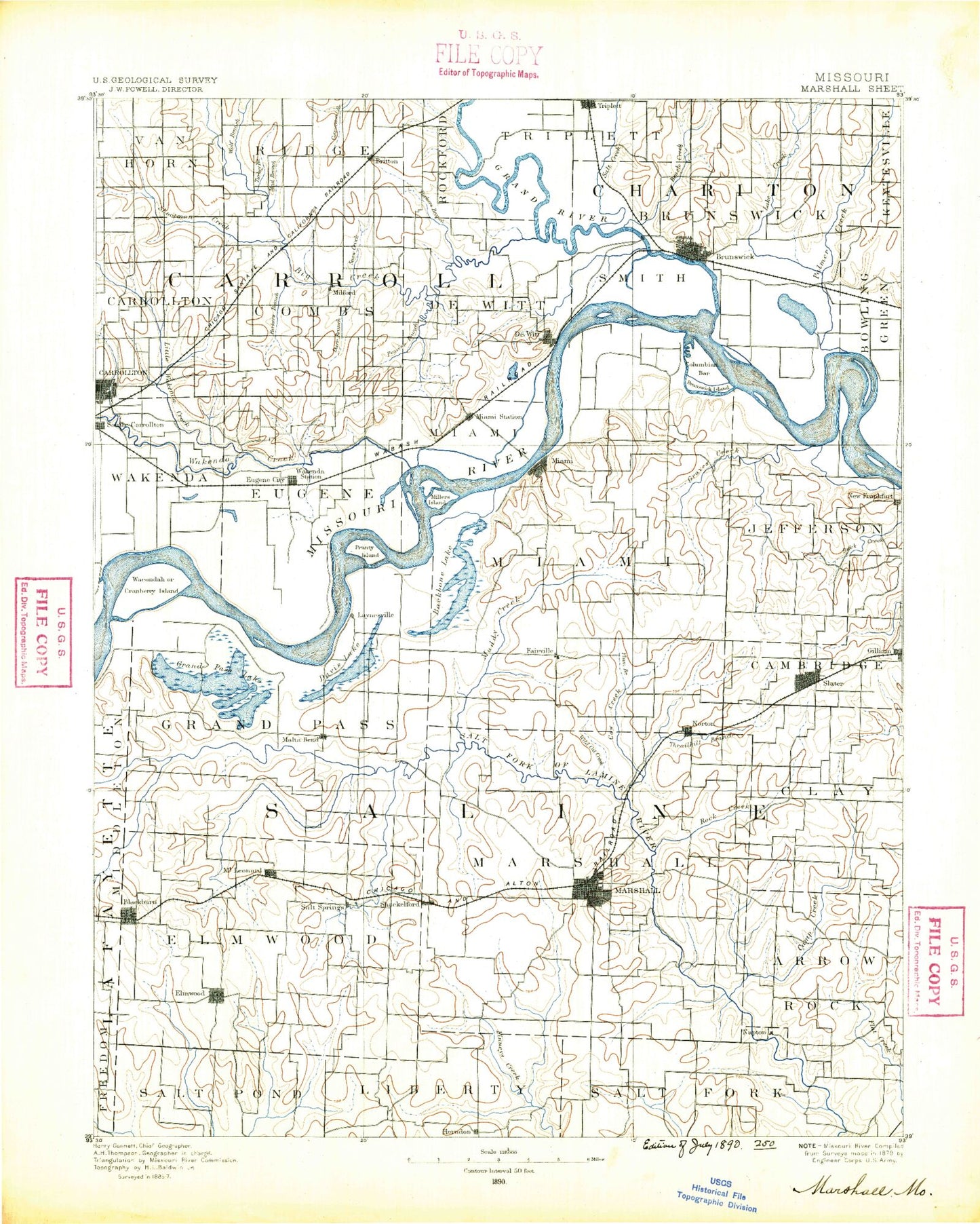
Historical USGS topographic map of Marshallin the states of Missouri, Iowa. Scale: 1:125000. Print size: 17" x 24"
This map was published in 1890 and is in the following counties: Carroll, Chariton, Cooper, Lafayette, Saline.
The map contains contour lines, roads, rivers, towns, streams, and lakes. Printed on high-quality waterproof paper with UV fade-resistant inks.
Contains the following named places: Bear Creek, Bell Branch, Big Creek, Blackburn, Blind Pony Wildlife Area, Brunswick, Brush Creek, Brush Creek, Camp Creek, Camp Creek, Carrollton, Coon Hollow, Cottonwood Branch, Cow Creek, Cranberry Chute, Cretcher, Crooked Creek, Cut-Off Lake, Darr Branch, De Witt, Dicks Branch, East Cow Creek, East Fork Elm Branch, East Fork Salt Pond Creek, Edmondson Creek, Elm Branch, Elmwood, Fish Lake, Gilliam, Grand Pass, Grand River, Herndon, Indian Foothills Park, Lake Creek, Lick Branch, Little Wakenda Creek, Malta Bend, Marshall, Miami, Miami Station, Miller Branch, Montague Hill, Mount Leonard, Mud Branch, Muddy Creek, Napton, North Fork Finney Creek, Parker Branch, Parker Branch, Pass Branch, Peavine Branch, Plum Branch, Pony Creek, Potter Slough, Rock Creek, Salt Branch, Salt Branch, Salt Branch, Salt Creek, Salt Fork, Sand Branch, Shackleford, Shields Hill, Shiloh Branch, Shootman Creek, Slater, Snow Branch, South Carrollton, Standley Branch, Straddle Creek, Teteseau Lake, Thrailkill Branch, Turkey Creek, Van Meter Ditch, Van Meter State Park, Wakenda Chute, West Cow Creek, West Fork Finney Creek, White Rock, Whites Island, Wildcat Branch, Wolf Branch, Wolf Branch, New Frankfort, Bosworth, Standish, Wakenda, Wakenda Creek, Grand Port, Triplett, Kelly Junction, Blue Lick, Fairville, Hardeman, Leta, Norton, Orearville, Salt Springs, Sharon, Stanhope, Wilton Springs, Town and Country Mall, Plaza Mall, Milford, Blackburn Pond, Town and Country Lake, Saline County, Only Way Lake Dam, Slater Lake, Wallys Lake Dam, Wallys Lake, Cooks Lake Dam, Cooks Lake, Anderson Lake Dam, Anderson Lake, Grace Lake Dam, Grace Lake, Number 155 Dam, Agee Lake Dam, Agee Lake, Horseshoe Lake Dam, East Lake Dam, East Lake, Johnson Lake Dam, Johnson Lake, Blackburn Pond Dam, Robertson Lake Dam, Robertson Lake, Van Meter Dam, Lake Wooldridge, Moore Lake Dam, Moore Lake, Lakeview Dam, Pence Dam, Pence Lake, Number 275 Dam, Stoll Lake Dam, Stoll Lake, Marshall State School Lake Dam, Marshall Habilitation Center Lake, State School Dam B, Elson Lake Dam, Elson Reservoir, Number 512 Dam, Reische Lake Dam, Reische Lake, Bryan Lake Dam, Bryan Lake, Marsh Lake Dam, Marsh Lake, MFA Research Farm Lake Dam, MFA Research Farm Lake, Miles Lake Dam, Rasse Lake Dam, Rasse Lake, Town and Country Lake Dam, Vogel Lake Dam, Vogel Lake, Peterson Lake Dam, Peterson Lake, Blind Pony Lake Dam, Blind Pony Lake, Township of Carrollton, Township of Combs, Township of De Witt, Township of Eugene, Township of Ridge, Township of Rockford, Township of Van Horn, Township of Wakenda, Township of Brunswick, Township of Arrow Rock, Township of Cambridge, Township of Clay, Township of Elmwood, Township of Grand Pass, Township of Marshall, Township of Miami, Township of Salt Fork, Grand Pass Conservation Area, Bakers Bend, Cranberry Bend, Hills Island Chute, Hills Bend, Tamerlane Bend, Malta Bends, Prunty Bend, Teteseau Bend, Thomas Bend, Upper Miami Bend, Middle Miami Bend, Lower Miami Bend, Dewitt Bend, Brunswick Bend, Levee Unit Number L-246, Bushwhacker Bend, Grand River Bend, Graves Creek, City of Brunswick, City of Carrollton, City of Blackburn, City of Bosworth, City of De Witt, City of Marshall, City of Miami, City of Slater, Town of Malta Bend, Town of Mount Leonard, City of Gilliam, City of Triplett, Village of Grand Pass, Grand River