MyTopo
Historic 1942 Marthas Vineyard Massachusetts 30'x30' Topo Map
Couldn't load pickup availability
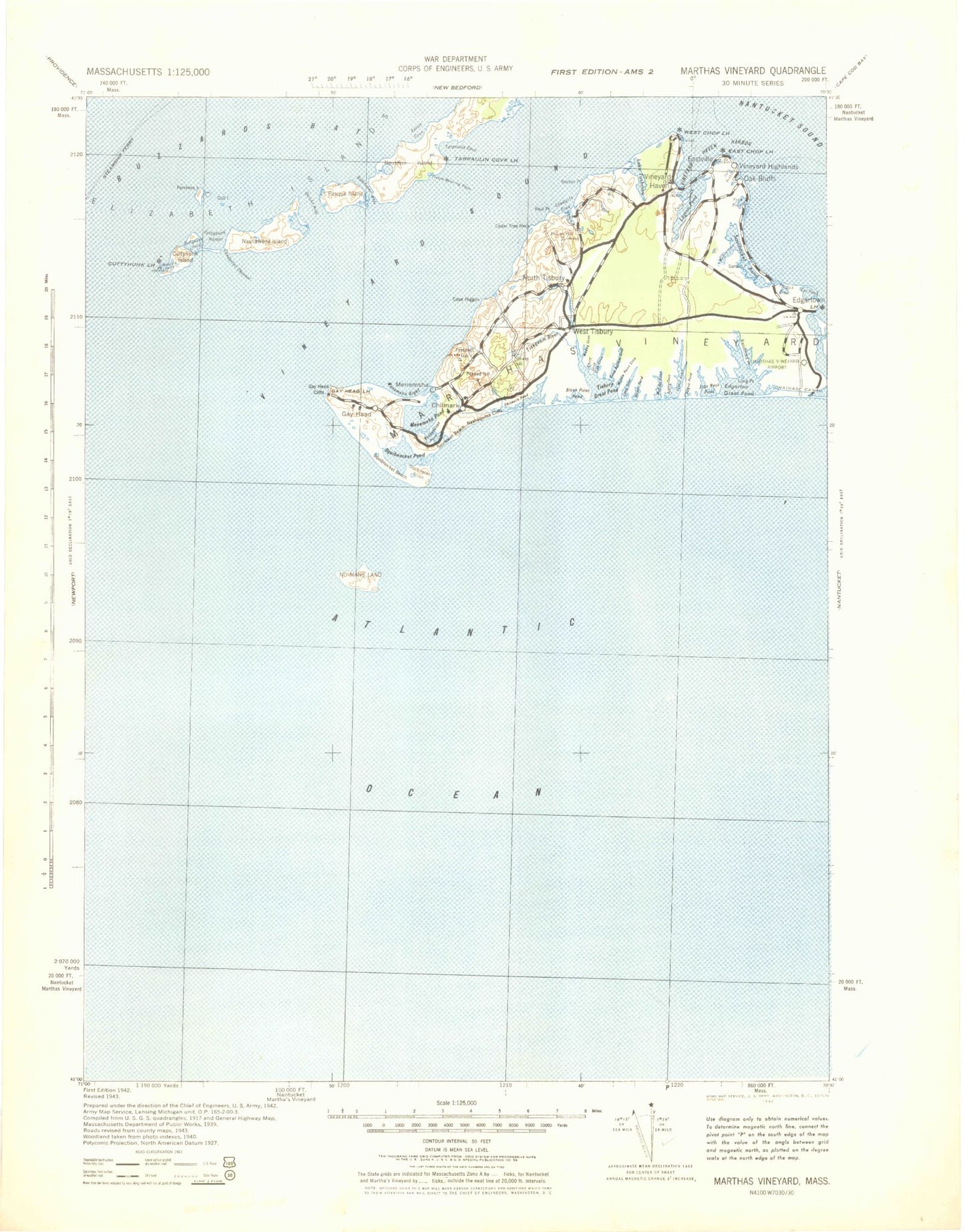
Historical USGS topographic map of Marthas Vineyard in the state of Massachusetts. Scale: 1:125000. Print size: 18" x 24"
This map was published in 1942 and is in the following counties: Barnstable, Bristol, Dukes.
The map contains contour lines, roads, rivers, towns, streams, and lakes. Printed on high-quality waterproof paper with UV fade-resistant inks.
Contains the following named places: Peaked Hill, Nantucket Shoals, Mishaum Ledge, Martha's Vineyard Aero Light, Gay Head Lighthouse, East Chop Light, West Chop Light, Edgartown Harbor Light, Oak Bluffs Ferry Slip Light, Oak Bluffs North Breakwater Light, Vineyard Haven Breakwater Light, Vineyard Haven Ferry Slip Light, Lake Tashmoo East Jetty Light, Tarpaulin Cove Light, Cuttyhunk Light, Menamsha Creek Entrance Jetty Light, Cuttyhunk Harbor North Jetty Light, Edgartown Memorial Park, Veira Park, Waban Park, Joseph Sylvia State Beach Park, Squibnocket Marshes, Eel Pond Marshes, Caleb Pond Marshes, James Pond Marshes, Farm Pond Marshes, Sengekontacket Pond Marshes, Dutcher Dock, East Chop Beach Club, Fisher Pond Dam, Crocker Pond Dam, Katama Neck, Katama Wharf, Cape Higgon, Tashmoo Hill, Old Man, Sow and Pigs Reef, Martha's Vineyard State Forest, Lone Rock, Whale Rock, Middle Ground, Middle Ledge, Felix Ledge, Sheriffs Pond, Gosnold Island, Dukes County, Martha's Vineyard Country Club, Baret Island, Canapitsit Channel, Copicut Neck, Cuttyhunk, Cuttyhunk Harbor, Cuttyhunk Island, Cuttyhunk Pond, Edwards Rock, Elizabeth Islands, Fox Point, Gull Island, Knox Point, Lone Rock, Middle Pond, Nashawena Island, The Neck, North Point, North Rock, Pasque Island, Pease Ledge, Penikese Island, Quicks Hole, Quicks Hole Pond, Rock Island, Saddleback Hill, South Rock, Westend Pond, Whale Rock, Abel Hill, Black Brook, Black Pond, Black Woods, Blaney Pond, Bliss Pond, Mount Cary, Chilmark, Crane Pond, Crescent Beach, Duck Pond, Eagle Hollow, Edys Island, Fulling Mill Brook, Gay Head, Gay Head, Gay Head Cliffs, Great Swamp, Grey Pond, Harlock Pond, Cape Higgon, Indian Lands, Jobs Neck, Lily Pond, Lobsterville, Long Beach, Long Point, Lucas Shoal, Menemsha, Menemsha Basin, Menemsha Beach, Menemsha Bight, Menemsha Creek, Menemsha Pond, Mill Brook, Molasses Pond, Nashaquitsa, Nashaquitsa Cliffs, Nashaquitsa Pond, Naushon Island, Naushon Point, Naushon Station, Occooch Pond, Point Mill Brook, Peases Point, Prospect Hill, Rams Head, Ramshead Woods, Robinsons Hole, Silver Beach, South Bluff, South Bluff, Squibnocket, Squibnocket Beach, Squibnocket Bight, Squibnocket Point, Squibnocket Pond, Squibnocket Ridge, Stonewall Beach, Stonewall Pond, Mount Surat, Wequobsque Cliffs, West Beach, Westend Pond, Witches Glen, Zacks Cliffs, Blackwater Brook, Brown Point, Cedar Neck, Cedar Tree Neck, Crocker Pond, Davis Pond, Deep Bottom, Doggetts Pond, Duarte Pond, Duarte Ponds, Ferry Boat Island, Fisher Pond, Flat Bottom Pond, Flat Point, Goat Rocks, Great Plains, Hines Point, Hullman Point, Husselton Head, James Pond, Kuffies Point, Lagoon Pond, Lily Pond, Little Pond, Looks Pond, Makonikey Head, Middle Ground, Mill Brook, Mink Meadows Pond, Mud Creek, North Head, North Tisbury, Norton Point, Norton Rock, Oklahoma Heights, Old House Pond, Old Millpond, Paul Point, Pilot Hill, Priester Pond, Rhoda Pond, Robbins Rock, Seths Pond, Lake Tashmoo, Upper Lagoon Pond, Vineyard Haven, Vineyard Haven Harbor, West Chop, West Chop, West Tisbury, Whiting Hill, Witch Brook, Allen Point, Black Point Pond, Chilmark Pond, Cobbs Point, Flat Point, Homer Pond, Jobs Neck Pond, Long Point, Nabs Corner, Oyster Pond, Paqua Pond, Pear Tree Cove, Plum Bush Point, Quansoo, Quenames Cove, Ridge Hill, Scrubby Neck, Tiasquam River, Tisbury Great Pond, Tississa, Tississa Pond, Waldron Bottom, Watcha Pond, Willow Tree Bottom, Beetle Swamp, Bluefish Point, Bold Water Point, Bran Point, Butler Neck, Butler Neck Point, Brush Island, Brush Pond, Chappaquiddick, Chappaquiddick Point, Clevelandtown, Crackatuxet Cove, Crystal Lake, Dividend Point, Dodger Hole, East Chop, East Chop, East Chop Flats, Eastville