MyTopo
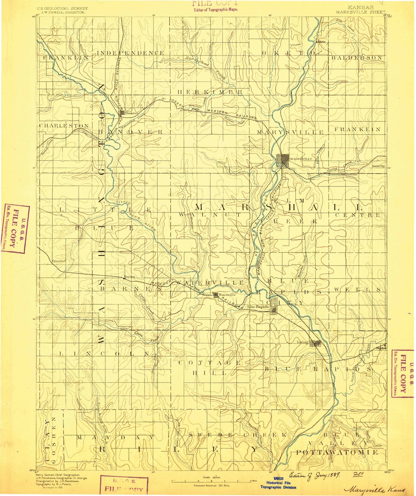
Historic 1889 Marysville Kansas 30'x30' Topo Map
Couldn't load pickup availability
Historical USGS topographic map of Marysvillein the states of Kansas, Nebraska. Scale: 1:125000. Print size: 17" x 24"
This map was published in 1889 and is in the following counties: Clay, Marshall, Pottawatomie, Riley, Washington.
The map contains contour lines, roads, rivers, towns, streams, and lakes. Printed on high-quality waterproof paper with UV fade-resistant inks.
Contains the following named places: Township of Franklin, Joy Creek, Township of Charleston, Mill Creek, Hanover, Hollenberg, Township of Independence, Horseshoe Creek, Township of Hanover, Cottonwood Creek, Township of Herkimer, Township of Logan, Raemer Creek, Meadow Creek, Little Indian Creek, Veterans Memorial Park, Hollenberg Ranch State Park, Bremen, Township of Oketo, Township of Marysville, Herkimer, Nieman Creek, Deer Creek, Indian Creek, Scotch Creek, Township of Balderson, Township of Franklin, Blodgett Creek, Lily Creek, Spring Creek, Bommer Creek, North Elm Creek, Marietta, Oketo, Township of Logan, Township of Little Blue, Malone Creek, Beaver Creek, Jonah Creek, Lane Branch, Cedar Creek, Mountain Creek, Walnut Creek, Bolling Creek, Spring Creek, Mercer Creek, Knedlik Creek, Hop Creek, Township of Walnut, East Fork Walnut Creek, Township of Elm Creek, Marysville, Dargatz Park, Rocky Run, Dutch Creek, Township of Center, Home, Schell Creek, Elm Creek, Township of Greenleaf, Township of Kimeo, Coon Creek, Township of Barnes, Township of Lincoln, Camp Creek, Greenleaf, Barnes, Township of Waterville, Township of Cottage Hill, Sulphur Creek, Waterville, Blue Rapids, Riverside Park, Little Blue River, Fawn Creek, Township of Blue Rapids City, Township of Blue Rapids, Township of Wells, Corndodger Creek, Black Vermillion River, Game Fork, Indian Mound, Township of Bigelow, Deadman Creek, Township of May Day, Township of Swede Creek, Little Swede Creek, Swede Creek Recreation Area, Tuttle Creek Reservoir State Wildlife Management Area, Timber Creek, Shannon Creek, Spring Creek, Fourmile Creek, Bluff Creek, Township of Spring Creek, Twin Mounds, Idlewild Lake, Waterville Dam, Alcove Springs Park, Spence, Hermansberg, Lone Elm, Alcove Spring, Shroyer, Upland, Carden, Reedsville, Chepstow, Kimeo, Cottage Hill, Bestwall, Marshall County, Waterville Golf Course, City of Marysville, Spring Creek, City of Barnes, City of Blue Rapids, City of Hanover, City of Hollenberg, City of Greenleaf, City of Oketo, City of Waterville, Waterville Wastewater Treatment Facility, Hanover Wastewater Plant, Blue Rapids Sewer Treatment Plant, Marysville Wastewater Treatment Facility, Greenleaf Wastewater Treatment Plant, Marshall County Fairgrounds, Barnes Wastewater Plant, Home City Sewer District Number 1, Black Squirrel Mobile Home Park, Country Acres Trailer Court, Marysville Country Club, Beattie Farmers Union Co - Operative Association Grain Elevator Number 2, Beattie Farmers Union Co - Operative Association Grain Elevator Number 4, Beattie Farmers Union Co - Operative Association Grain Elevator Number 5, Lewis Seed and Fertilizer - Home City Grain Elevator Number 1, Joy Creek, Horseshoe Creek, Little Indian Creek, Deer Creek, Indian Creek, Little Blue River, Spring Creek