MyTopo
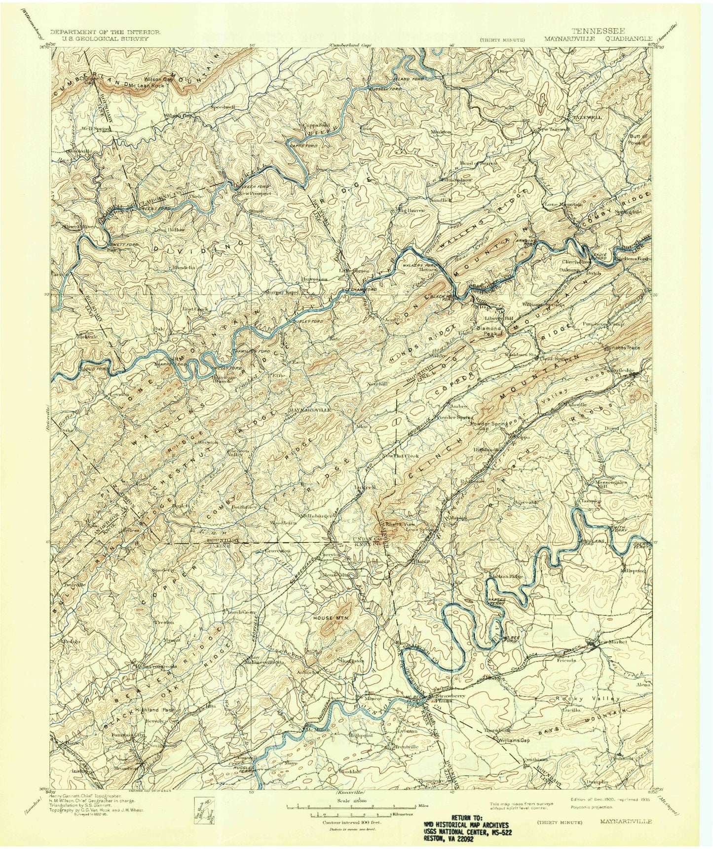
Historic 1900 Maynardville Tennessee 30'x30' Topo Map
Couldn't load pickup availability
Historical USGS topographic map of Maynardville in the state of Tennessee. Scale: 1:125000. Print size: 17" x 24"
This map was published in 1900 and is in the following counties: Anderson, Campbell, Claiborne, Grainger, Jefferson, Knox, Sevier, Union.
The map contains contour lines, roads, rivers, towns, streams, and lakes. Printed on high-quality waterproof paper with UV fade-resistant inks.
Contains the following named places: Big Ridge, Blaine, Bob Hollow, Buck Hollow, Buffalo Hollow, Buffalo Ridge, Carr Branch, Chestnut Flat, Chestnut Ridge, Chuck Swan Wildlife Management Area, Clear Springs, Clinch Valley, Comb Ridge, Crooked Run, Donehew Head, Donehew Hollow, Duncan Hollow, Dungeon Hollow, Dyer Branch, Flat Creek, Flat Creek Valley, Foust Hollow, Frost Branch, Hamilton Gap Branch, Huckleberry Springs Branch, Indian Ridge, Jimtown Hollow, Kitts Point, Laurel Hollow, Lea Creek, Lea Lake, Lick Branch, Little Creek, Little Flat Creek, Little Valley, Log Mountain, Log Mountain, Lone Mountain, Lone Mountain Creek, Lone Mountain Ridge, Loyston Dike, McAnnally Ridge, Mell Fall Hollow, Mile Branch, Needham Hollow, Norris Lake, Perrin Hollow, Poor Valley Knobs, Powder Spring Gap, Promised Land Hollow, Raccoon Creek, Race Track Bluff, Richland Creek, Richland Knobs, Richland Valley, Rocky Valley, Rutledge, Sheep Hollow, Sheeplick Point, Shelby Hollow, Sherman Hollow, Shields Cove, Shiflet Ridge, Shipetown, Short Hollow, Signal Point, Silo Hollow, Sinking Creek, Skaggston, Slate Creek, Smith Branch, Smith Branch, Smith Hollow Branch, Smithwood, South Fork Beaver Creek, Speedwell, Spencer Hollow, Spout Spring Branch, Spring Place, Standing Stone, Stansbury Hollow, Still Branch, Stillhouse Hollow, Stiner Dock, Stiner Hollow, Stiner Ridge, Stout Knob, Stover Gap, Straight Branch, Suckstone Creek, Sugar Creek Hollow, Sugar Hollow, Sugar Tree Gap, Sweet Gum Bend, Sycamore Knobs, Sycamore Tunnel, Tabler Branch, Tanner Hollow, Tate Hollow, Tazewell, Temple Acres, Texas Hollow, Texas Valley, Thomas Knob, Three Points, Tony Hollow, Trentville, Tumbling Run, Turkey Ridge, Tuttle Hollow, Tyes Branch, Upper Fall Branch, Vannoy Hollow, Vineyard Bend, Wagon Hollow, Wallop Hollow, Wallop Hollow, Watercress Pond, Watson Ridge, Weaver Knob, Weaver Ridge, Welch Hollow, Welch Ridge, West Branch, Whispering Hills, Whistle Valley, White Creek, White Oak Branch, Whiteoak Flats, Whiteoak Ridge, Whites Creek, Whittle Springs, Whittle Springs Golf Club, Wildcat Hollow, Wildcat Spur, Woolardtown, Williams Creek, Williams Hollow, Williamson Ridge, Willow Fork, Wilson Bend, Wilson Gap, Wolfpen Hollow, Wood Duck Island, Wood Hollow, Wooddale, Woods Creek, Wyricktown, Yellow Branch, Yellow Cliff Hollow, Young Zinc Mine, Zachary Branch, Acuff Gap, Ailor Gap, Allen Branch, Altizer Hollow, Alum Cave Hollow, Andersonville Dock, Arlington, Ault Lake, Ausmus Hollow, Bailey Gap, Bailey Hollow, Bailey Knob, Baker Hollow, Baldwin Hill, Ball Creek, Bates Hollow, Bayless Gap, Bays Mountain, Bean Hollow, Bear Creek, Bear Hole Bend, Bear Hole Island, Beard Valley, Beaver Brook Country Club, Beaver Creek, Bee Branch, Beech Grove Cabin Area, Beech Island, Beeler Hollow, Berry Hollow, Bethel Branch, Betts Hollow, Beverly, Big Bend, Big Branch Hollow, Big Cliff, Big Ridge Lake, Big Ridge State Park, Big Sink, Big Sinks, Big Spring Hollow, Big Valley, Birch Hollow, Black Fox, Black Fox Valley, Black Hollow, Black Oak, Blowing Spring Gap, Blowing Spring Hollow, Blue Spring Branch, Blue Springs Branch, Bonta Vista Estates, Bostic Bend, Bounds Hollow, Bower Hollow, Braden Hollow, Bradley Branch, Brantley Hollow, Brassfield Bend, Brewer Hollow, Brewer Ridge, Brice Branch, Bridges Hollow, Brookfield Acres, Brown Gap, Bruner Hollow, Brushy Knob, Booker Hollow, Buffalo Creek, Buffalo Hide Creek, Buffalo Springs Game Farm, Buffat Heights, Bull Ridge, Bullen Valley, Bunches Trace, Bunky Hollow, Burchfield Hollow, Burke Hollow, Burnett Hollow, Butcher Gap, Buzzard Knob, Caldwell Branch, Calf Island, Calloway Hollow