MyTopo
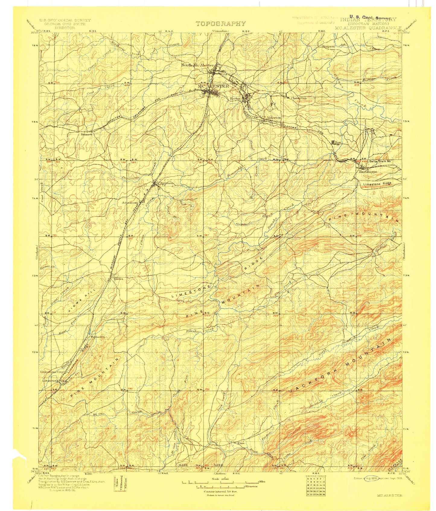
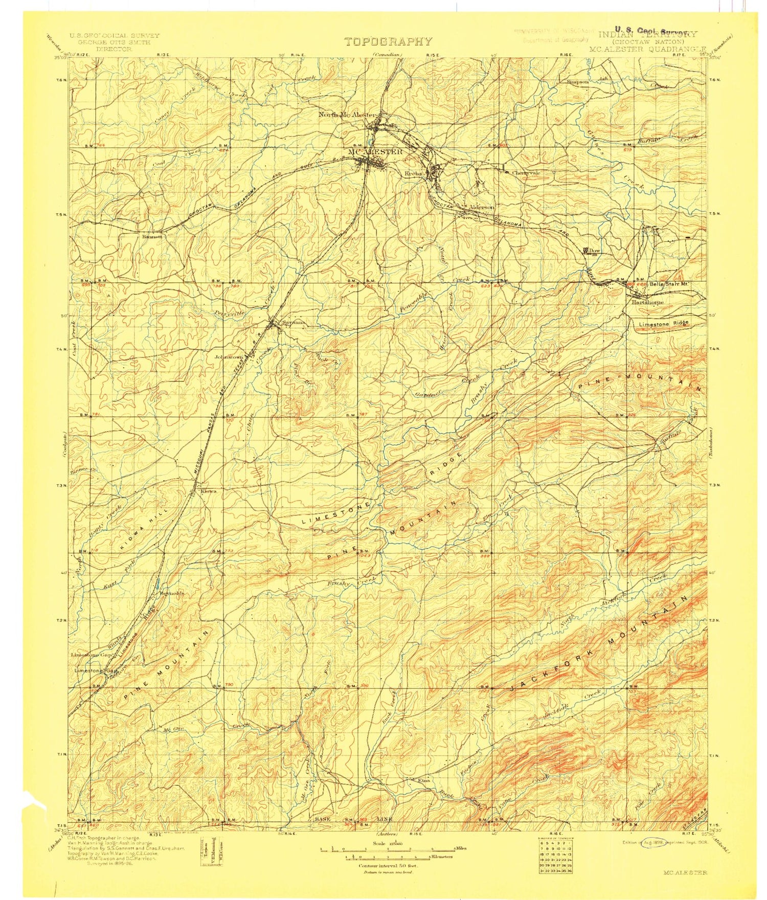
Historic 1898 McAlester Oklahoma 30'x30' Topo Map
Couldn't load pickup availability
Historical USGS topographic map of McAlester in the state of Oklahoma. Scale: 1:125000. Print size: 18" x 24"
This map was published in 1898 and is in the following counties: Atoka, Latimer, Pittsburg, Pushmataha.
The map contains contour lines, roads, rivers, towns, streams, and lakes. Printed on high-quality waterproof paper with UV fade-resistant inks.
Contains the following named places: Adamson, Alderson, Anderson Creek, Arch Branch, Arpelar, Ash Creek, Baker Branch, Bald Knob, Bald Mountain, Bald Mountain, Baxter Branch, Belle Starr Mountain, Big Caney Mountain, Big Prairie Ridge, Big Wildhorse Creek, Birch Creek, Blanco, Blue Creek, Blue Mountain, Bolen Creek, Bolen Hollow State Public Hunting Area, Bow Mountain, Brier Creek, Brown Lake, Brush Narrows, Brushy Creek, Buck Creek, Buck Hill, Buffalo Creek, Buffalo Mountain, Bull Creek, Burris Valley, Cedar Creek, Cedar Creek, Chadick Park, Chambers, Chippewa Creek, Chun Creek, Clear Creek, Clear Creek, Coal Hill, Cole Creek, Coon Creek, Country Club Lake, Cyclone Mountain, Daisy Mountain, Dancing Rabbit Creek, Deer Creek, Dow, Dow Lake, Doyal Creek, Dry Branch, Elm Creek, Fish Trap Mountain, Fivemile Creek, Fobb Creek, Fobb Ridge, Gaines Creek, Gap, Gardner Creek, Grassy Creek, Grubb Mountain, Hackett Mountain, Haileyville, Happy Hollow, Hartshorne, Hartshorne Lake, Haywood, Hewitt Mountain, Hickory Point Recreation Area, Highway 31 Landing Recreation Area, Hogeye Creek, Hogeye Hollow, Ingersoll Creek, Jackfork Mountain, Kiowa, Kiowa Hill, Kiowa Lake, Krebs, Krebs Lake, Lee Park, Limestone Creek, Limestone Ridge, Little Caney Creek, Little Caney Mountain, Little Wildhorse Creek, Lone Rock, Low Gap, Martin Lake, McAlester, Middle Branch Clear Creek, Miller Creek, Modisette Creek, Mud Creek, Mud Creek, Lime Arch Bridge, New State Mountain, Nolleytuby Creek, North Fork Elm Creek, North McAlester, Number Ten Mountain, Oil Well Hollow, Peaceable Creek, Peveyhouse Creek, Pine Creek Mountain, Pine Knob, Pine Mountain, Piney Branch, Piney Mountain, Pittsburg, Pittsburg Lake, Pocahontas Mountain, Prairie Creek, Puterbaugh Park, Pyle Mountain, Rabbit Creek, Reynolds Lake, Rock Creek, Rock Creek, Rock Creek, Rock Town, Rocket Lake, Round Top Mountain, Rush Canyon, Sandy Creek, Sassafras Creek, Satterfield Branch, Savanna, Sawmill Hollow, Sharp Hollow, Shoat Mountain, Short Creek, Smithson Lake, South Fork Elm Creek, Spring Hollow, Storrie Lake, Tackett Branch, Tanner Creek, Ti Creek, Ti Valley, Tommy Bond Branch, Turkey Mountain, Wade Mountain, Whiskey Knob, Wild Horse Gap, Wildcat Creek, Wildcat Mountain, Wildhorse Creek, Winslow Creek, Wolf Creek, Yellowjacket Hollow, Youth Lake, Adel, Arch, Bond, Burg, Carbon, Centerville, Chockie, Counts, Craig, Daisy, Frink, Goss, Limestone Gap, Pine Top, Redden, Reynolds, Richville, Star, Ti, Weathers, Wesley, Pittsburg County, Lake Talawanda Number Two, Bache, Prison Lake Dam, Prison Lake, Oknoname 121019 Dam, Oknoname 121019 Reservoir, Oknoname 005001 Dam, Oknoname 005001 Reservoir, Oknoname 131007 Reservoir, Dow Lake Dam, Dow Lake, Youth Lake Dam, Fin Feather Lake Dam, Fin and Feather Lake, Pittsburg Dam, Brushy Peaceable Creek Site 16 Dam, Burshy Peaceable Creek Site 16 Reservoir, Brushy Peaceable Creek Site 17 Dam, Brushy Peaceable Creek Site 17 Reservoir, Brushy Peaceable Creek Site 31 Dam, Burshy Peaceable Creek Site 31 Reservoir, Brushy Peaceable Creek Site 32 Dam, Brushy Peaceable Creek Site 32 Reservoir, Brushy Peaceable Creek Site 33 Dam, Brushy Peaceable Creek Site 33 Reservoir, Burshy Peaceable Creek Site 37 Dam, Brushy Peaceable Creek Site 37 Reservoir, Brown Lake Dam, Brushy Peaceable Creek Site 9 Dam, Brushy Peaceable Creek Site 9 Reservoir, Brushy Peaceable Creek Site 10 Dam, Brushy Peaceable Creek Site 10 Reservoir, Brushy Peaceable Creek Site 11 Dam, Brushy Peaceable Creek Site 11 Reservoir, Hartshorne Lake Dam, Hartshorne Lake, Storrie Lake Dam, Jones Lake Dam, Jones Lake, Smithson Lake Dam, Kiowa Lake Dam, Bill Hopper Lake Dam, Hopper Lake, Oknoname 121001 Dam, Oknoname 121001 Reservoir, Oknoname 121006 Dam, Oknoname 121006 Reservoir, Oknoname 121007 Dam, Oknoname 121007 Reservoir, Oknoname 121009 Dam, Oknoname 121009 Reservoir, Oknoname 121010 Dam, Oknoname 121010 Reservoir, Oknoname 121012 Dam, Oknoname 121012 Reservoir, Oknoname 121013 Dam, Oknoname 121013 Reservoir, Oknoname 121016 Dam, Oknoname 121016 Reservoir, Oknoname 121017 Dam, Oknoname 121017 Reservoir, Country Club Lake Dam