MyTopo
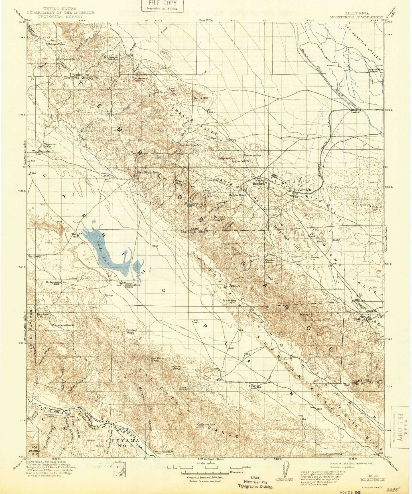
Historic 1912 McKittrick California 30'x30' Topo Map
Couldn't load pickup availability
Historical USGS topographic map of McKittrick in the state of California. Scale: 1:125000. Print size: 17" x 24"
This map was published in 1912 and is in the following counties: Kern, San Luis Obispo, Santa Barbara.
The map contains contour lines, roads, rivers, towns, streams, and lakes. Printed on high-quality waterproof paper with UV fade-resistant inks.
Contains the following named places: A F Traver Ranch, Abbott Canyon, Associated Oil Camp, Bacon Hills, Bacon Hills Area, Belridge Ditch, Browns Canyon, Caliente Mountain, Carneros Creek, Carneros Rocks, Carrizo Canyon, Chalk Mountain, Cochora Ranch, Cooper Ranch, Corn Camp, Corn Camp Ditch, Cottonwood Canyon, Crocker Canyon, Cuyama, Dabney Canyon, Derby Acres, Elk Grove Ranch, Elkhorn Plain, Frazer Valley, Galainena Ranch, Gould Hill, Green Valley Ranch Number Two, Hale McLeod Canyon, Hanline Ranch, Hillcrest Point, Kelly Canyon, Kelsey Canyon, Kern County Land Company Ranch, Kern River Flood Canal, L E Traver Ranch, Las Yeguas Ranch, Layman Area, Lease Camp, Lease Camp, Main Drain, McKittrick, McKittrick Summit, McKittrick Valley, Midway Oil Camp, Midway Peak, Miranda Canyon, Missouri Triangle, Morales Canyon, Mustang Canyon, Painted Rock, Painted Rock Ranch, Palomas Drain, Post Canyon, Pottinger Canyon, Powell Canyon, R C Farm, Red Rock Canyon, Ross Ranch, Salt Creek Area, Saltos Canyon, School House Ditch, Seaback Ranch, Selby Ranch, Selby Ranch Cow Camp, Seventeen Canyon, Sheep Camp, Spanish Ranch, Spoor Canyon, Taylor Canyon, Telephone Hills, Temblor Ranch, The Old Adobe, Twentyone Canyon, Washburn Ranch, Wells Ranch, West Side Canal, Whiterock Bluff, Willow Springs Valley, Wood Canyon, Zemorra Creek, Midoil, Simmler, Elk Hills, Elkhorn Scarp, Panorama Point, San Diego Creek, Santos Creek, Temblor Range, Temblor Valley, Aramburu Canyon, Canal Seventeen, Canal Eighteen, Carneros Canyon, Chico Martinez Creek, Crocker Flat, American Ranch, Caliente Range, Carrizo Plain, Chimineas Ranch, Deadman Flat, Goodwin Ranch, Green Canyon, Saucito Ranch, Schoolhouse Canyon, Soda Lake, Turkey Camp, Russel Ranch Oil Field, Chico Martinez Oil Field, Cymric Oil Field, Government Eighteen Oil Field, Morales Canyon Oil Field, South Belridge Oil Field, Standard Oil, Taylor Canyon Oil Field, Temblor Ranch Oil Field, Tidewater Associated Oil, Union Oil, Welport Oil, Lokern Pumping Station, Midway Pumping Station, Panorama Hills, Salt Creek, Temblor Creek, Fellows, Lokern, Reward, Little Santa Maria Valley, A M Cooper Ranch, Maddux Canyon, Mama Pottinger Canyon, Old Cooper Ranch, Cauvel Ranch, Excel Pit, Farm Camp Quarry Number 5, Carrizo Plain National Monument