MyTopo
Historic 1911 Meadows Idaho 30'x30' Topo Map
Couldn't load pickup availability
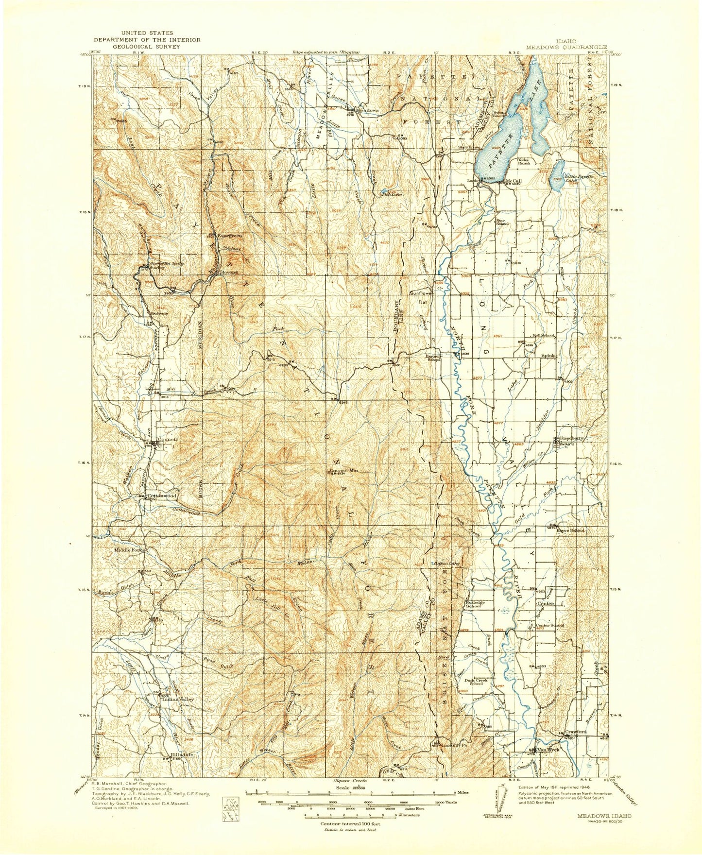
Historical USGS topographic map of Meadows in the state of Idaho. Scale: 1:125000. Print size: 17" x 24"
This map was published in 1911 and is in the following counties: Adams, Gem, Valley.
The map contains contour lines, roads, rivers, towns, streams, and lakes. Printed on high-quality waterproof paper with UV fade-resistant inks.
Contains the following named places: Big Creek Meadows, Corral Creek Guard Station, Indian Valley, Indian Valley, King Hill Creek, Monday Gulch, Westside Lake Fork Ditch, Hillsdale School, Anderson Creek, Anderson Creek Trail, Arling Trail, Bar Creek, Bear Basin, Bear Gulch, Bear Gulch, Beaver Creek, Beaver Creek, Bell Saddle, Bench Creek, Big Creek, Big Creek, Black Lake, Blackwell Lake, Blue Bunch Ridge, Boulder Creek, Boulder Creek, Boulder Ditch, Buck Saddle, Bucks Basin, Bull Corral Creek, Burnt Wagon Basin, Cabin Creek, Cabin Creek Trail, Camp Creek, Campbell Creek, Cascade Park, Lake Cascade, Cougar Island, Cold Creek, Cold Spring Creek, Cold Spring Gulch, Cold Spring Ridge, Cutoff Saddle, Cookhouse Gulch, Cool Creek, Corral Creek, Cottonwood Basin, Cottonwood Creek, Cougar Basin, Shellworth Island, Council Lookout, Council Mountain, Cruickshank Reservoir, Cruzen Ditch, Cruzen Pond, Crystal Creek, Curtis Creek, Davis Creek, Deer Creek, Deseret Cabin, Dewey Creek, Dog Creek, Donnelly Trail, Dry Beaver Creek, Duck Bay, Duck Creek, Duffner Creek, Duston Creek, East Branch Goose Creek, East Fork King Hill Creek, East Fork Lost Creek, East Fork Weiser River, Ecks Flat, Evergreen, Fall Creek, Fall Creek, Finn Creek, Fire Gulch, First Gulch, Fish Creek, Fort Hall Hill, Fourth Gulch, French Creek, Gaylord Creek, Gibson Creek, Glen Cove Creek, Glendale, Gold Fork Canal, Gold Fork River, Goose Creek, Grandmas Creek, Granite Basin, Granite Creek, Granite Creek Trail, Grossen Canyon, Grouse Creek, Grouse Knoll, Hartsell Creek, Hatties Creek, Hoover, Hornet Creek, Hornet Ridge, Hot Spring Creek, Hubbard Basin, Hurd Creek, Jug Creek, Jumbo Creek, Jungle Creek, Jungle Creek Trail, Potato Knob, Laffinwell Creek, Lake Fork, Lake Irrigation District Canal, Landing Creek, Larkspur Gulch, Last Chance Campground, Lemah Creek, Lester Creek, Lightning Point, Little Creek, Little Creek, Little Fall Creek, Little Mud Creek, Little Weiser Trail, Log Cabin Gulch, Lone Tree, Lookout Peak, Lost Creek, Lost Fork Creek, Louie Creek, Lucks Point, Mahala Ditch, Meadow Creek, Meadows Hill, Meadows, Meridian Gulch, Mica Creek, Mica Hill, Mica Mine, Mica Ridge, Mica Saddle, Middle Fork Weiser River, Mill Creek, Mill Creek, Mill Creek, Mill Creek Trail, Moorehead Flat, Mosquito Creek, Mud Creek, Mud Creek, Murphy Creek, New Meadows, No Business Canyon, No Business Mountain, No Business Saddle, North Beach, North Fork Cottonwood Creek, North Fork Fourth Gulch, North Fork Grays Creek, North Fork Mill Creek, Paradise Point, Parks Creek, Payette Lake, Pilgrim Cove, Pin Creek, Ping Creek, Poison Lake, Poison Timber Point, Ponderosa State Park, Poorman Creek, Price Valley, Railroad Creek, Red Point, Rock Creek, Rock Flat, Rock Lake, Rocky Gulch, Roseberry Ditch, Rough Creek, Scott Corral, Second Gulch, Sheep Creek, Sheep Creek, Sheep Trail, Shingle Creek, Shingle Flat, Silver Creek, Skern Creek, South End Ditch, South Fork Grouse Creek, South Fork Mill Creek, South Fork East Fork King Hill Creek, Spink Barker Ditch, Spring Creek, Squaw Flat, Squaw Lake, Stover Creek, Stover Meadow, Stringer Ditch, Sugarloaf, Sunflower Flat, Surprise Creek, Sylvan Beach, Sylvan Creek, Tamarack, Tamarack Gulch, The Dike, The Narrows, Third Gulch, Thorn Creek, Thorn Creek, Thorn Creek Fire Camp, Thrush Creek, Timber Ridge, Trail Creek, Trail Creek, Trestle Creek, Tyee Creek, Upper Jug Creek Reservoir, Van Wyck Sheep Trail, Vick Creek, Wagon Bay Creek, Wagon Wheel Bay, Warm Spring Creek, Warm Spring Gulch, West Branch Goose Creek, West Fork Beaver Creek, West Fork Weiser River, White Licks, White School, Wilhelm Creek, Williams Creek, Willow Creek, Wolf Creek, Wood Gulch, Woodland Creek