MyTopo
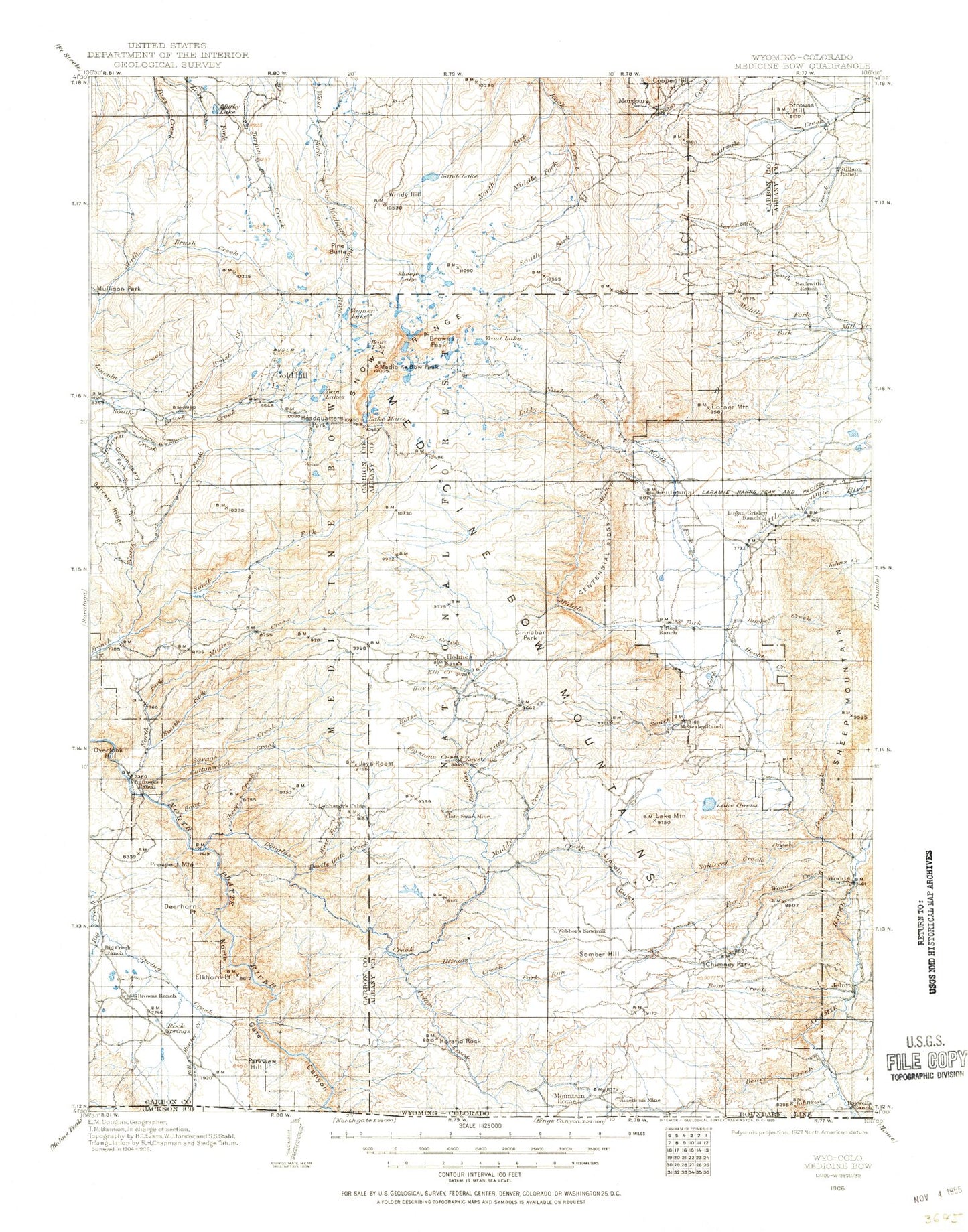
Historic 1906 Medicine Bow Wyoming 30'x30' Topo Map
Couldn't load pickup availability
Historical USGS topographic map of Medicine Bow in the state of Wyoming. Scale: 1:125000. Print size: 17" x 24"
This map was published in 1906 and is in the following counties: Albany, Carbon, Jackson.
The map contains contour lines, roads, rivers, towns, streams, and lakes. Printed on high-quality waterproof paper with UV fade-resistant inks.
Contains the following named places: Platte River Wilderness, Sixmile Creek, Medicine Bow Mountains, Boswell Creek, Johnson Creek, Spring Creek, Bliler and Boswell Ditch, Barber Lake, Bear Lake, Bellamy Lake, Big Creek Ranch, Black Jack Lake, Browns Peak, Camp Creek, Centennial, Centennial Ridge, Cliff Mine, Corner Mountain, Deerhorn Point, Dipper Lake, Elkhorn Point, Fall Creek, Fourlog Park, Gold Run Creek, Hall Gulch, Hanging Lake, Hat Park, Headquarters Park, Heart Lake, Hourglass Lake, Independence Mine, Jim Creek, Klondike Lake, Lewis Lake, Lewis Lake Campground, Libby Creek, Libby Creek Picnic Ground, Libby Flats, Libby Lake, Little Brooklyn Lake, Long Lake, Lookout Lake, Lost Lake, Lake Marie, Markle Ditch, Medicine Bow Peak, Medicine Bow Ski Area, Mill Pond Lake, Mirror Lake, Mullen Creek, Nash Fork, Nash Fork Picnic Ground, Nelson Park, North Fork Campground, North Twin Lake, Old Channel Ditch, Parkview Hill, Pollock Draw, Prospect Mountain, Sally Creek, Silver Lake, Silver Lake Campground, Silver Run Creek, Silver Run Lake, Sixmile Gap, Sixmile Picnic Ground, Snowy Range Pass, South Gap Lake, South Twin Lake, Stovepipe Gulch, Sugarloaf Mountain, Swastika Lake, Telephone Creek, Telephone Lakes, Trail Creek, University of Wyoming Camp, University of Wyoming Science Camp, Upper Nash Fork Campground, Upper Silver Run Lake, Willow Park, Wyocolo, Domick Ditch, Medicine Bow National Forest, Upper Missouri Lake, Silverman Lake, Lower Missouri Lake, Knapp Lake, Pelton Park, Brooklyn Lake Guard Station, Centennial Ranger Station, A Bar A Ranch, Albany, American Mine, Anderson Creek, Anderson Ditch, Arlington Pack Trail, Arrastre Creek, Arrastre Lake, Arrowhead Lake, Aztec Creek, Badger Creek, Bald Mountain, Barrett Ridge, Basin Ranch, Bear Creek, Bear Creek, Beaver Creek, Bellamy Ditch, Bert Creek, Bird Creek, Boat Creek, Boswell Ranch, Bow River Overlook, Buckeye Creek, Bunker Hill, Campbell Lake, Carlson Park, Carlson Park Guard Station, Cascade Lake, Cassidy Creek, Castle Rock, Cecil Park, Centennial Valley, Chimney Park, Chimney Park Camp, Cinnabar Park, Clark Park, Collins Creek, Cooper Hill, Corral Lake, Cottonwood Creek, Coyote Hill, Crater Lake, Crescent Lake, Curitan Creek, Cutthoat Lake, Dale Creek, Dave Creek, Deep Creek Campground, Deep Lake, Deerwood, Devils Gate Creek, Douglas Creek, Douglas Creek Campground, Douglas Creek Picnic Ground, Douglas Point, Dry Park, Eagle Creek, East Banner Lake, East Fork Devils Gate Creek, East Walbright Creek, Elk Creek, Elkhorn Creek, Evans Creek, Evans Creek Campground, Fence Creek, Fish Creek, Fish Creek Park, Flume Creek, Flume Creek Park, Fox Creek, Fox Creek Ditch, Foxpark, French Creek Picnic Ground, French Creek Ranch, Glacier Lakes, Gold Hill, Golden Gate Prospect, Golden Key Mine, Gramm, Gramm Creek, Grindstone Park, Hans Creek, Harden Creek, Hay Creek, Hay Park, Headquarters Creek, Hecht Creek, Hells Canyon, Henry Creek, Henry Ditch, Holmes Campground, Horatio Rock, Horse Creek, Hubbell Ditch, Illinois Creek, Illinois Creek Campground, Indian Creek, Iron Creek, Iron Mountain, Jays Roost, Jeff Lake, Jelm Creek, Jelm P O, Jim Creek, Johnson Park, June Creek, Kelly Creek, Keystone, Keystone Creek, Keystone Guard Station, Keystone Mine, Keystone Ranger Station, Lake, Lake Creek, Lake Creek Resort, Lake Mountain, Lake Owen Creek, Lewis Creek, Lincoln Gulch, Little Beaver Creek, Lookout Mountain, Lost Lake, Lost Park, Manthos Ranch, Meadows Lakes, Middle Fork Little Laramie River, Middle Fork Rock Creek, Middle French Creek, Mill Creek, Miller Lake, Murky Lake, Moores Gulch, Mountain Home, Mountain Meadow Ranch, Mowberg Creek, Muddy Creek, Muddy Mountain, Muddy Park, Mullen Creek, Mullison Park, Mutt Lake, Nellis Creek, New Jelm, North Banner Lake, North Fork