MyTopo
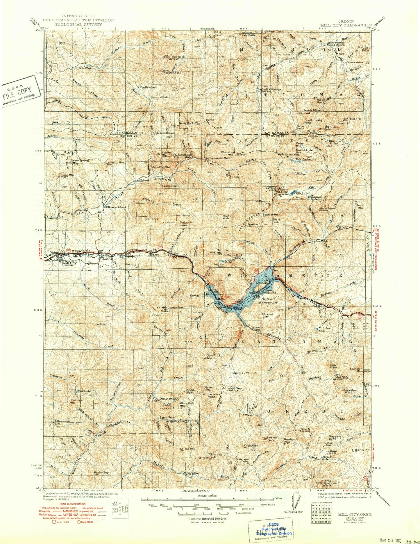
Historic 1929 Mill City Oregon 30'x30' Topo Map
Couldn't load pickup availability
Historical USGS topographic map of Mill City in the state of Oregon. Scale: 1:125000. Print size: 17" x 24"
This map was published in 1929 and is in the following counties: Clackamas, Linn, Marion.
The map contains contour lines, roads, rivers, towns, streams, and lakes. Printed on high-quality waterproof paper with UV fade-resistant inks.
Contains the following named places: Bear Creek, Bee Ranch, Big Creek, Bruno Lakes, Camp Twenty-six, Canyon Creek, Copperhead Creek, Cougar Creek, Crabtree Lake, Crabtree Mountain, Four Bit Creek, Gates, Gates Guard Station, Gawley Creek, Hall Creek, High Rock, Horse Creek, Jo Jo Lake, Little Rock Creek, Little Sinker Creek, Lookout Mountain, Lookout Mountain Lookout, Mill City, Moorehouse Creek, Moose Creek, Panther Creek, Potato Hill, Rocky Top, Snake Creek, Sweet Spring Creek, Sweet Spring Mountain, Tom Rock, Trout Creek, Wildcat Ridge, Yellowstone Creek, Yellowstone Guard Station, Yellowstone Mountain, Minto Creek, Anderson Creek, Roland Creek, Chamberlain Creek, Bear Creek, Homestead Creek, Butte Lakes, Fibre Rock, South Fork Butte Creek, Hell Cat Rock, Rhody Lake, Fibre Creek, Rhody Creek, Copper Lake, South Gawley Ridge, Boar Camp, Dog Rock, Slide Creek, Trestle Creek, Shoofly Creek, Inventory Creek, Gawley Meadow, North Gawley Ridge, Cow Creek, Picture Point, Fill Creek, Camp Creek, Murphy Camp, Pelkey Lake, Gun Creek, West Fork Quartzville Creek, Thomas Fork, DeFord Creek, Turnidge Creek, Santiam State Forest, McQuade Creek Shelter, McNabb Falls, Corbia Lake, Fibre Lake, Gawley Basin, Sucker Creek, Whispering Falls Recreation Site, Silver King Lake, House Mountain, The Maples Safety Rest Area, Cascade Falls, Gobblers Knob, Harry Mountain, South Fork Packers Gulch, Maple Creek, Crash Creek, Twin Falls Creek, Sixes Creek, Edison Creek, Galena Ridge, Red Heifer Pass, East Fork Packers Gulch, Cave Creek, Elk Creek, Beverly Creek, Howell Pond, Niagara County Park, Silver King Mine, Packsaddle County Park, Salmon Falls County Park, Panther Rock, Albany Mine, Alder Swamp Shelter, Avalanche Creek, Bachelor Mountain, Bad Banks Creek, Battle Ax, Battle Ax Creek, Battle Creek, Battle Creek Shelter, Beabe Creek, Beachie Saddle, Beachie Trail, Bear Creek, Bear Lake, Bear Lake Creek, Beard Creek, Beard Saddle, Big Slide Lake, Big Slide Mountain, Big Washout Creek, Black Eagle Mine, Blowout Cliff, Blowout Creek, Blue Jay Mine, Bonanza Mine, Boulder Creek, Boulder Creek, Boulder Peak, Breitenbush River, Bruler Creek, Bruno Meadows Trail, Buck Creek, Buck Creek, Buck Mountain, Buck Mountain, Buckeye Creek, Bull Creek, Bull of the Woods Trail, Burnt Mountain, Butte Creek, Byars Creek, Byars Peak, Camp Creek, Canal Creek, Canyon Creek, Cat Creek, Cedar Creek, Cedar Creek, Cedar Lake, Chimney Creek, Chimney Peak, Chimney Peak Trail, Cliffs Creek, Coffin Mountain, Coffin Mountain Trail, Cold Creek, Coopers Ridge, Copper Creek, Corset Creek, Crown Mine, Cub Point, Cultus Creek, Cumley Creek, Daly Lake, Deadhorse Creek, Detroit, Detroit Dam, Detroit Lake State Park, Divide Creek, Dog Tooth Rock, Dome Rock, Donaca Creek, Donaca Lake, Dry Creek, Dry Creek, Dry Gulch, Dungeon Creek, Dunlap Creek, Dunlap Lake, Dunno Creek, Dutch Creek Shelter, Eagle Rock, East Fork Collawash River, East Rock Creek, East Stack Creek, Egg Creek, Elephant Rock, Elk Creek, Elk Lake, Elk Lake Creek, Elk Lake Trail, Elkhorn, Elkhorn Creek, Elkhorn Lake, Elkhorn Mountain, Elkhorn Valley, Evans Mountain, Fan Creek, Farm Creek, Farm Trail, Fawn Creek, Fisher Point, Fitt Creek, Fox Creek, Fox Creek Trail, Freezeout Creek, French Creek, French Creek Ridge, French Creek Trail, Galena Creek, Galena Mountain, Gold Butte, Gold Creek, Gold Creek, Gold Peak, Gordan Peak, Gordan Peak Trail, Green Creek, Green Mountain, Gregg Creek, Hall Ridge, Hansen Creek, Happy Creek, Hawkins Creek, Hay Barn Creek, Heater Creek, Henline Creek, Henline Mountain, Henline Mountain Lookout, Henry Creek, Hoover Ridge, Horn Creek, Humbug Creek


