MyTopo
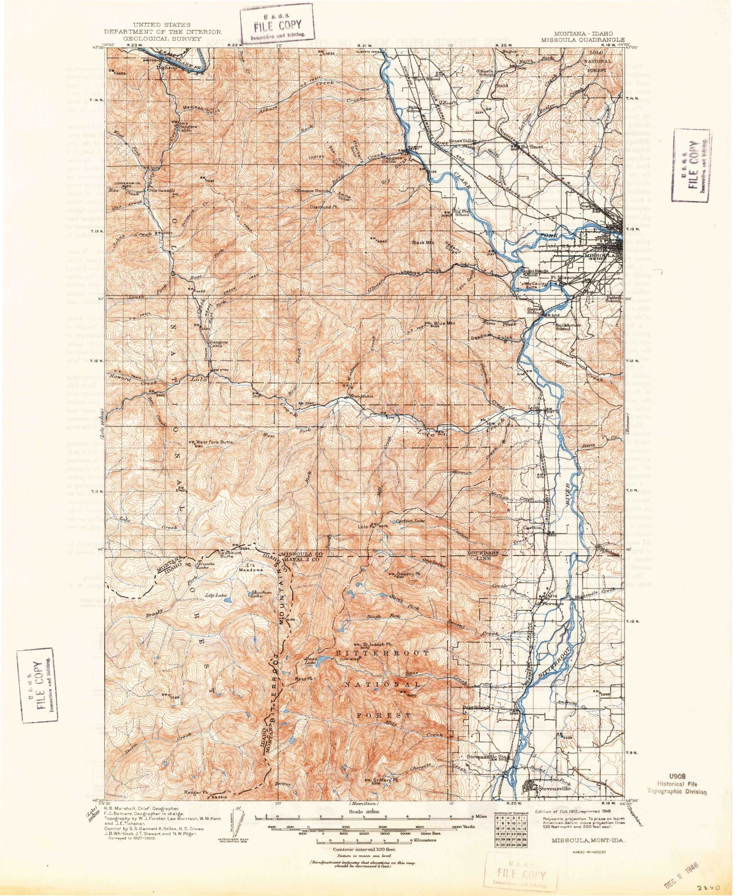
Historic 1912 Missoula Montana 30'x30' Topo Map
Couldn't load pickup availability
Historical USGS topographic map of Missoula in the state of Montana. Scale: 1:125000. Print size: 18" x 24"
This map was published in 1912 and is in the following counties: Idaho, Mineral, Missoula, Ravalli.
The map contains contour lines, roads, rivers, towns, streams, and lakes. Printed on high-quality waterproof paper with UV fade-resistant inks.
Contains the following named places: Skookum Butte, Old Stormy, Ranger Peak, Rocky Point, Stormy Pass, Mill Creek, Anderson Gulch, Black Mountain, Blue Mountain, Chickaman Mine, Gilman Creek, Hagerty Gulch, Lick Gulch, Lyon Gulch, Mailbox Gulch, North Fork Sleeman Creek, Schoolhouse Gulch, South Fork Sleeman Creek, Westerman Creek, Wild Horse Point, Lee Metcalf National Wildlife Refuge, Supply Ditch, Albert Creek, Albert Point, Ambrose Creek, Anderson Creek, Andrews Gulch, Antrim Lookout, Antrim Point, Bass Creek, Bass Lake, Bass Peak, Bear Creek, Bear Gulch, Big Flat, Big Flat Ditch, Bill Creek, Bitterroot River, Brooks Creek, Butler Creek, Cahoot Canyon, Camp Creek, Carlton, Carlton Creek, Carlton Lake, Carlton Lake Trail, Cedar Creek, Cedar Run Creek, Charles Waters Memorial Campground, Chickaman Gulch, Chief Joseph Gulch, Clark Creek, Cloudburst Creek, Cooley Gulch, Coppersmith Mine, Council Hill, Cyr Gulch, Davis Creek, Davis Creek, De Smet, Deadman Gulch, Deep Creek, Diamond Point, Dick Creek, Dog Gulch, Doyles Slough, Dry Gulch, Dry Gulch, Duffy Lake, East Fork Grave Creek, East Fork Petty Creek, Eds Creek, Eightmile Creek, Elderberry Gulch, Emma Gulch, Falls Creek, Field Doughery Ditch, Florence, Flynn Lowney Ditch, Franklin Park, Futter Gulch, Garden Creek, Garden Point, Grant Creek, Grass Valley, Grass Valley French Ditch, Grave Creek, Grave Creek Meadow, Grave Creek Range, Bruce Creek, Hayes Creek, Heavenly Twins, Hollensteiner Gulch, Holloway Lake, Howard Creek, Hungry Creek, Indian Gulch, Iron Cap Creek, John Creek, Johns Creek, Johny Creek, Kelly Island, Kennedy Gulch, Kenspur, Kirchey Creek, Kootenai Creek, La Valle Creek, Lantern Creek, Lantern Ridge, Lappi Lake, Larry Creek, Larson Creek, Lehsou Ditch, Little Carlton Lake, Little Martin Gulch, Lolo, Lolo Creek, Lolo Peak, Lolo Ranger Station, Lost Park, Lost Park Creek, Lothrop, Maclay Flats, Madison Gulch, Maple Creek, Martin Gulch, Martin Point, Marys Pond, McCalla Creek, McCauley Butte, McClain, McClain Creek, McClain Lake, McCormick Park, McLeod Park, Meadow Creek, Middle Creek, Middle Fork Lakes, Mike Creek, Mill Creek, Mill Creek Trail, Miller Creek, Million Gulch, Mills Lake, Moose Can Gully, Mormon Creek, Mormon Peak, North Bench, North Burnt Fork Creek, North Fork Howard Creek, North Fork Sweeney Creek, North Kootenai Lake, North One Horse Lake, North Swamp Creek, North Woodchuck Creek, O'Brien Creek, O'Keefe Creek, One Horse Creek, Orchard Homes, Pattee Creek, Peppard Gulch, Peterson Lake, Petty Creek, Petty Mountain, Playfair Park, Plummers Slough, Post, Potato Gulch, Primrose, Moulton Reservoir Number Two, Pyramid Buttes, Reed Lake, Reservoir Creek, Rock Creek, Sacajawea Park, Saint Joseph Peak, Saint Mary Peak, Saint Mary Peak Trail, Sally Ridge, Sally Ridge Trail, Schilling, Schilling Siding, Sharrott Creek, Sheldon Creek, Sherman Gulch, Sleeman Creek, Smith Creek, South Fork Lakes, South Fork Lolo Creek, South Fork Petty Creek, South Fork Sweeney Creek, South Kootenai Lake, South One Horse Lake, South Swamp Creek, Spring Creek, Spring Creek, Spring Gulch, Sin-tin-tin-em-ska Creek, Saint Mary Lake, Stevensville, Stevensville Reservoir, Sunset Memorial Park, Sweeney Creek, Sweeney Lake, Sweeney Peak, Sweeney Ridge Trail, Telephone Butte, Tevis Creek, Threemile Creek, Tie Chute Creek, Tucker Gulch, Ward Lode Mine, Warm Slough, Washington Park, West Fork Butte, West Fork Butte Creek, West Fork Petty Creek, West Side Park, Williams Preston Hovet Ditch, Woodchuck Creek, Woodman Creek, Worden Creek, Circle S Ranch, Gilman, Sheldon, Triantler, Lawyers Combination, Blue Mountain Saddle, Blue Mountain Lookout, Woodman Mine, Council Grove, Lewis and Clark Campground, Skookum Butte Lookout, West Fork Butte Lookout, Fort Fizzle Campground, Cooper Creek