MyTopo
Historic 1906 Mitchell Butte Oregon 30'x30' Topo Map
Couldn't load pickup availability
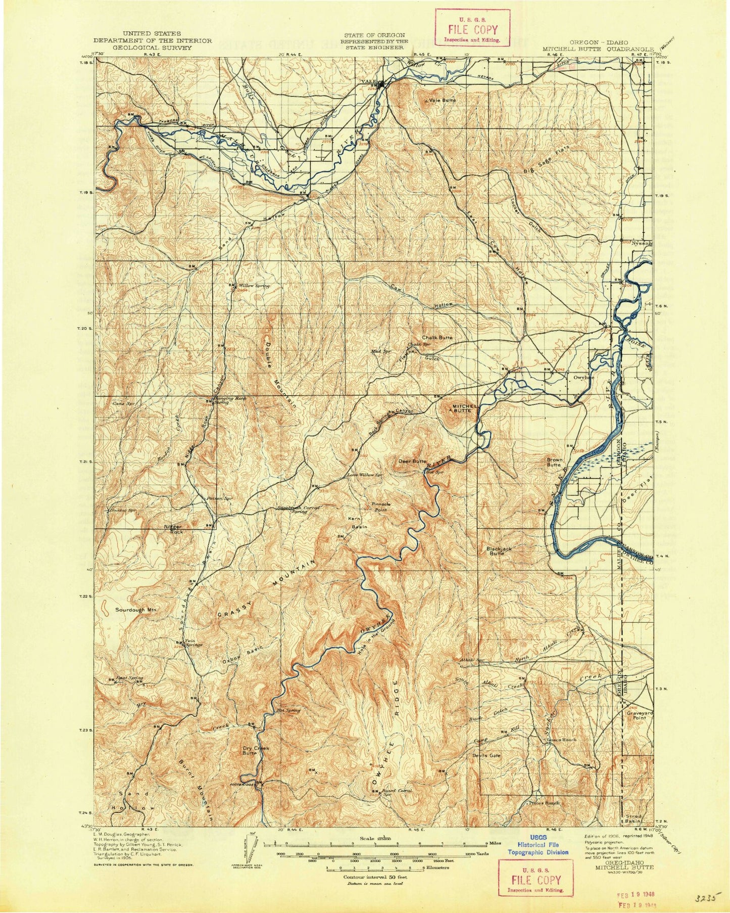
Historical USGS topographic map of Mitchell Butte in the state of Oregon. Scale: 1:125000. Print size: 17" x 24"
This map was published in 1906 and is in the following counties: Canyon, Malheur, Owyhee.
The map contains contour lines, roads, rivers, towns, streams, and lakes. Printed on high-quality waterproof paper with UV fade-resistant inks.
Contains the following named places: Central Alkali Drain, Five and Seventenths Canal, Imbler Drain, Strode Basin, Tunnel Number 6, Alkali Creek, Alkali Draw Reservoir, Allen Drain, Balancing Rock, Bas Reservoir, Basin Gulch, Bench Reservoir, Big Bend, Big Sage Flats, Birch Creek, Birch Creek Reservoir, Black Willow Gulch, Blackjack Butte, Board Corral Mountain, Board Corral Reservoir, Brown Butte, Buck Gulch, Buck Gulch Reservoir, Bullock Drain, Bully Creek Siphon, Cairo, Calhoun Reservoir, Camp Kettle Creek, Camp Kettle Reservoir, Canyon Reservoir, Central Alkali Drain, Chalk Butte, Chalk Reservoir, Chance Lateral, Chaney Reservoir, Cherry Creek, Coates Drain, Cow Hollow, Cow Hollow Siphon, Coyote Gulch, Dead Horse Canyon, Deer Creek, Devils Gate, Double Mountain, Dry Creek, Dry Creek Buttes, Dry Creek Buttes Reservoir, Dry Lake, East Bench, East Cow Hollow, East Cow Hollow Reservoir, Farmers Ditch, Findley Reservoir, Five and Seventenths Canal, Fletcher Gulch, Four Points Reservoir, Freezeout Creek, Freezeout Lake, Games Reservoir, Gibson Drain, Golden Gate Canal, Gordon Gulch, Grassy Mountain, Grassy Mountain Reservoir, Grassy Reservoir, Holly Drain, Hoodoo Creek, Hope Drain, Indian Creek, Iron Mountain, Iron Mountain Canyon, J-H Canal, Jamieson Gulch, Johnson Gulch, Jordan Drain, Kane Spring Gulch, Kane Spring Reservoir, Keck Slough, Kern Basin, King Drain, Kingman Drain, Kingman Lateral, Lake Owyhee State Park, Leaky Reservoir, Lincoln Bench, Lincoln Bench Reservoir, Little Sandy Reservoir, Little Valley, Little Valley Lateral, Locket Gulch, Locket Gulch Siphon, Lone Willow Creek, Long Draw, Lowe Reservoir, Lower Cow Reservoir, Lower Pump Canal, Mahogany Long Draw Reservoir, Malheur Canyon, Malheur Siphon, Mallett, Mallett Drain, Mill Ditch, Mitchell Butte, Mitchell Butte Lateral, Nannys Nipple, Napton, Negro Rock, Negro Rock Canyon, Nevada Canal, North Alkali Creek, North Alkali Draw Reservoir, North Branch Camp Kettle Creek, North Canal, North Canal Lateral, North Fork Rock Spring Canyon, North Grassy Mountain Reservoir, North Oakander Drain, Nyssa Drain, Oakander Drain, Oke Reservoir, Ontario Nyssa Canal, Owyhee Dam, Owyhee Ditch, Owyhee Ridge, Lake Owyhee, Oxbow Basin, Pinnacle Point, Prati Island, Pump Ditch, Red Drain, Rhinehart Buttes, Riverside Canal, Road Canyon, Rock Fence Reservoir, Rock Spring Canyon, Rock Spring Siphon, Rookie Creek, Rye Field, Sage Creek, Sagebrush Gulch, Sand Hollow, Sand Hollow, Sand Hollow Creek, Schweizer Reservoir, Sheep Creek, Sheep Creek Siphon, Singer Drain, Snively Gulch, Sourdough Basin, Sourdough Gulch, Sourdough Mountain, South Alkali Creek, South Alkali Drain, South Branch Camp Kettle Creek, South Canal, South Sheep Creek, Stradley Drain, Suzy Island, Swigert Cow Camp, Table Reservoir, The Elbow, Tunnel Canyon, Tunnel Number 3, Tunnel Number 4, Tunnel Number 5, Tunnel Number 7, Two Forks Check Dam, Upper Cow Reservoir, Upper Kane Spring Reservoir, V W McCormack Area, Vale Butte, Vines Ditch, Walker Drain, Welch Drain, West Bench, Wild Horse Basin, Wild Horse Creek, Wildcat Canyon, Wildcat Canyon Reservoir, Yellowjacket Reservoir, Needham Reservoir, Stacey Ditch, Biggs Ditch, Boston Drain, Johnston Gulch Reservoir, Russell Drain, Robbins Drain, Purvis Drain, Big Bend Park, Burnt Mountain, Blackjack Butte Reservoir, Poison Spring Reservoir, Gordon Creek, Rock Spring Creek, Owyhee Dam Park, Dry Creek Camp, Hammond Hill, Dunaway, Richland, Kingman Kolony, Nyssa Heights, White Settlement, Bishop Ditch, Sheephead Mountain, Big Elbow, Burnt Elbow, Kingman, Succor Creek Siphon, North Alkali Creek Siphon, The Tongue, Coyote Gulch Siphon, Snively Siphon, Owyhee Siphon, Black Willow Siphon, Mills Dam Number 2, Mills Dam Number 1, Mills Dam Number 3, Captain Keeney Pass, Dry Creek Arm, Albertsons Dam, Albertsons Reservoir 'A', Broken Rim Check Dam, Broken Rim Reservoir, Stark Reservoir, Adrian, Burnt Mountain, Cairo Junction, Deer Butte, Haystack Rock, Overstreet, Owyhee, Shell Rock Butte, Vale, Vines Hill, Owyhee River, Tunnel Number 1