MyTopo
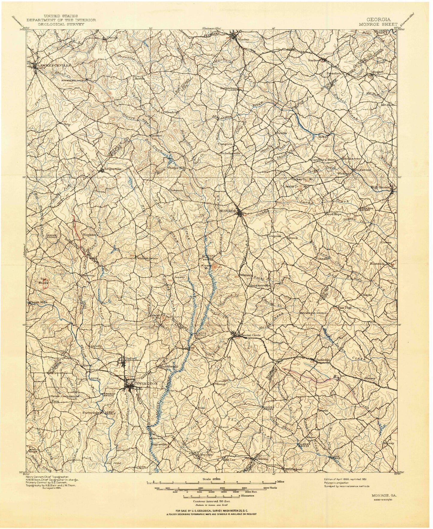
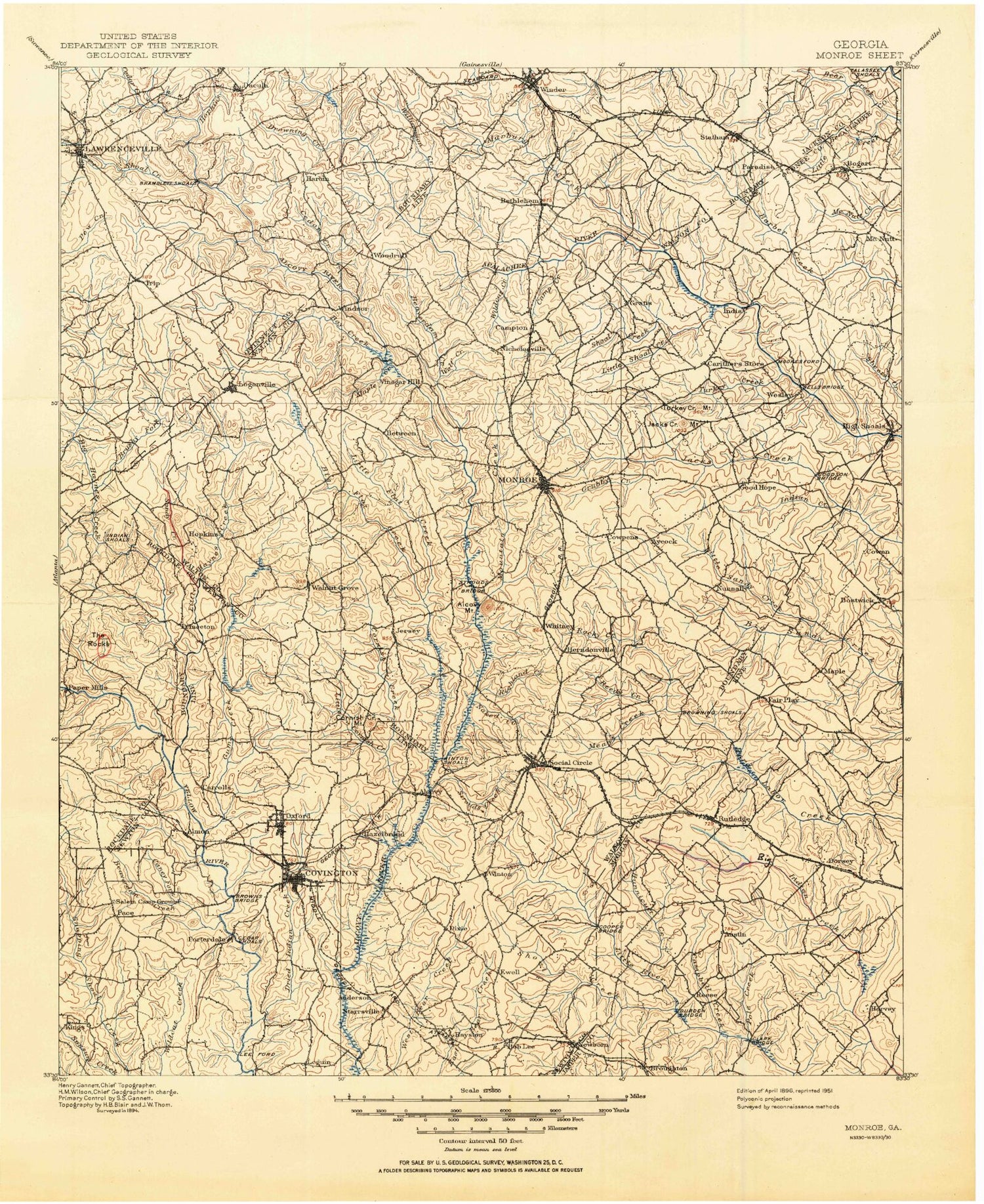
Historic 1896 Monroe Georgia 30'x30' Topo Map
Couldn't load pickup availability
Historical USGS topographic map of Monroe in the state of Georgia. Scale: 1:125000. Print size: 18" x 24"
This map was published in 1896 and is in the following counties: Barrow, Clarke, Gwinnett, Jackson, Jasper, Morgan, Newton, Oconee, Rockdale, Walton.
The map contains contour lines, roads, rivers, towns, streams, and lakes. Printed on high-quality waterproof paper with UV fade-resistant inks.
Contains the following named places: Marbury Creek, Alcovy Mountain, Almand Creek, Almon, Baker Branch, Bay Creek, Beaver Lake, Beaverdam Creek, Beaverdam Creek, Between, Big Flat Creek, Big Haynes Creek, Lake Brantley, Brick Store, Lake Brooks, Browning Shoals, Brushy Fork, Buck Branch, Byrds Lake, Camp Creek, Camp Daniel Morgan, Camp Rutledge, Caney Fork, Carls Twin Lakes, Lake Carlton, Carr Branch, Cedar Creek, Cedar Creek, Cedar Shoals, Cornish Creek, Cornish Mountain, Costley Millpond, Covington Reservoir, Crows, Dennis Creek, Dials Millpond, Dog Branch, Dove Creek, Dried Indian Creek, Drowning Creek, Ellis Lake, Fort Yargo State Park, Gibson Branch, Glass Creek, Good Hope, Grayson, Green Branch, Grubby Creek, Gum Creek, Hard Labor Creek State Park, Hays Pond, Hester Branch, Hi-Roc Lake, Hightower Indian Trail Monument, Hinton Shoals, Hopkins Creek, Horseshoe Bend, Hunnicut Creek, Hurricane Creek, Indian Creek, Ivey Branch, Johnson Lake, Lane Creek, Langston Shoals, Lawrenceville, Lawrenceville Campground, Little Bear Creek, Little Cornish Creek, Little Creek, Little Flat Creek, Little Gum Creek, Little Haynes Creek, Little Panther Creek, Little Sandy Creek, Little Shoal Creek, Lokeys Lake, Long Branch, Mansfield, Maple Creek, Masseys Lake, Means Creek, Lake Monroe, Moons Lake, Mountain Creek, Mountain Hill Branch, Naked Creek, Nelson Creek, New Hope, Newborn, Nowell Recreation Center, Lake Oconee, Pace, Palm Creek, Parkers Lake, Patrick Branch, Patrick Pond, Perkins Lakes, Peters Branch, Pole Creek, Pony Express, Quigg Branch, Rawlings Branch, Rays Lake, Reedy Creek, Rice Creek, Richland Creek, Roberts Branch, Rockdale Lake, Rocky Branch, Rocky Branch, Rocky Creek, Rocky Creek, Rocky Creek, Rutledge, Rutledge Lake, Lake Rutledge, Salem Campground, Sandy Creek, Shoal Creek, Shoal Creek, Shoal Creek, Shoemaker Branch, Smiths Lake, Springs Park, Statham, Still Branch, Strouds Creek, Stuarts Lake, Tanyard Branch, Turkey Creek, Turkey Creek, Turkey Creek Mountain, Wildcat Creek, Williamson Creek, Winder, Winfield Creek, Wolf Creek, Wrights Creek, Alcovy, Braswell, Broughton, Brownwood, Caruthers Mill, Eastville, Ebenezer, High Point, Reese, Snows Mill, Starrsville, Whitney, Windsor, Alcovy Mountain, Allendale, Barrow Heights, Bethlehem, Bostwick, Centennial, Dialtown, Dickson, Dixie, Dorsey, Forest Hills, Griffin Mountain, Harbin, Hayston, Herndonville, Hub Junction, Jacks Creek Mountain, McElroys Mill, Milstead, Mount Vernon, Oxford, Porterdale, Rosebud, Russell, Social Circle, Split Silk, Walker Park, Walnut Grove, Whistleville, Youth, Zingara, Lawrenceville City Park, Gwinnett County Fairgrounds, Dacula Park, Tribble Mill Park, Dacula, Barber Creek Watershed Number 26 Dam, Dam Number 26, Meeks Lake Dam, Meeks Lake, Lake Oconee Dam, Mooney Dam, Mooney Lake, Saye Dam, Saye Lake, Lake Rutledge Dam, Lake Brantley Dam, Lewis Lake Dam, Lewis Lake, Powell Dam, Powell Lake, Lawrenceville City Dam, Lawrenceville City Lake, Arnold Dam, Arnold Lake, Johnson Lake Dam, Kennerly Dam, Kennerly Lake, Lake Carlton Dam, Dove Dam, Dove Lake, Dam Y3, Webb Lake, Bushy Haynes Creek Watershed Structure Number 21 Dam, Brooks Lake, Dew Dam 25, Dew Lake, Haynes Pond Number Three, Tuggle Dam 22, Tuggle Lake, Elder Lake Dam, Harrison Dam, Harrison Lake, Marbury Lake Dam, Marbury Lake, Marburg Creek, Barber Creek Watershed Structure 25 Dam, Barber Creek, McLocklin Lake, Watershed Lake Dam, Watershed Lake, Stone Lea Lake Dam, Stone Lea Lake, Stone Lea Lake Dam, Upper Williams Lake Dam