MyTopo
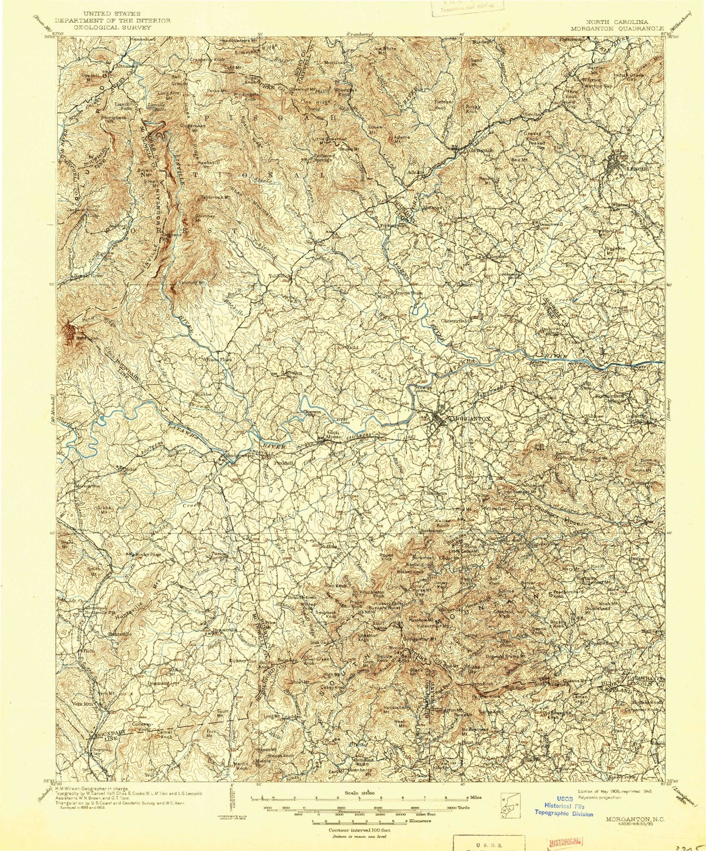
Historic 1905 Morganton North Carolina 30'x30' Topo Map
Couldn't load pickup availability
Historical USGS topographic map of Morganton in the state of North Carolina. Scale: 1:125000. Print size: 17" x 24"
This map was published in 1905 and is in the following counties: Avery, Burke, Caldwell, Catawba, Cleveland, Lincoln, McDowell, Mitchell, Rutherford.
The map contains contour lines, roads, rivers, towns, streams, and lakes. Printed on high-quality waterproof paper with UV fade-resistant inks.
Contains the following named places: Adams Branch, Allen Branch, Allen Mountain, Arneys Store, Bailey Creek, Bailey Fork, Baker Branch, Bakers Creek, Bald Knob, Bald Knob Creek, Ball Alley, Ball Alley Creek, Barnes Branch, Baton, Bear Creek, Beaverdam Branch, Betts Gap, Big Branch, Biggerstaff Mountain, Black Fork, Black Fox Ridge, Bolin Gap, Bolin Knob, Box Creek, Bridge Branch, Brier Creek, Brindle Creek, Buck Hollow Branch, Bumgarther Mountain, Burkemont, Burkemont Mountain, Buzzard Roost, California Branch, Cambric Branch, Camel Knob, Camp Branch, Camp Creek, Cane Creek Mountain, Carpenter Knob, Casar, Cedar Knob, Chestnut Cove Branch, Chestnut Knob, Chestnut Knob, Chimney Branch, Chimney Gap, Cobb Branch, Collins Creek, Conoway Knob, Cove Branch, Cove Mountain, Cox Creek, Cub Creek, Dales Creek, Lake David, Devils Fork, Double Branch, Dye Branch, Dysartsville, Earl Mountain, East Prong Hunting Creek, Fero, Fiddlers Run, Fork Creek, Fork Mountain, Gamewell, Gap Branch, Garrison Creek, Gibbs Gap, Gilead Ridge, Glenwood, Grass Ridge, Grassy Knob, Gray Branch, Grayson Creek, Green Branch, Hardburgain Branch, Harrison Branch, Hartland, He Creek, Hensley Ridge, High Peak, High Shoals Creek, Hipp Creek, Honeycutt Tunnel, Horse Mountain Gap, Horse Ridge, Howard Creek, Hoyle Creek, Hunting Creek, Huntsville Branch, Huntsville Mountains, Indian Grave Gap, Indian Grave Gap, Island Creek, Ivy Creek, Jackson Branch, Jim Long Mountain, Johanna Branch, Jumping Branch, Keller Knob, Kelly Branch, Lane Branch, Laurel Creek, Leman Gap, Lisenberry Mountain, Little First Broad River, Little Mountain, Little River, Lone Mountain, Long Mountain, Lookadoo Mountain, Magazine Branch, Marks Mountain, Marlin Knob, McCall Lake, McGalliard Creek, Micol Creek, Mill Branch, Mineral Springs Mountain, Molly Fork, Mollys Branch, Moores Branch, Morganton, Negro Creek, Nettle Branch, Newcomb Branch, North Cove, North Fork First Broad Creek, North Fork Sally Queen Creek, Owl Hollow, Pasture Mountain, Petche Gap, Petersburg, Petty Gap, Pheasant Creek, Pigeon Mountain, Pigpen Mountain, Pilot Mountain, Piney Mountain, Pleasant Grove, Pond Ridge, Pot Branch, Poundingmill Creek, Prospect Ridge, Pumpkin Center, Queen Branch, Queens Creek, Queens Creek, Rainbow Mountain, Ramsey, Rector Knob, Red Spur, Richland Mountain Ridge, Rock Creek, Rockey Face Mountain, Rockhouse Creek, Roper Creek, Rust Mountain, Salem, Sandy Branch, Scott Mountain, Scrub Grass Branch, Secrets Creek, Seeley Creek, Shaft Ridge, Shinny Creek, Shoal Branch, Shoal Creek, Shoal Mountain, Shooks Creek, Sims Branch, Sisk Gap, Smalley Creek, Smart Branch, Smith Branch, Smith Mountain, Smoky Creek, Somey Creek, South Creek, South Fork Hoppers Creek, South Mountain, South Mountains, Spruce Branch, Stacy Creek, Stafford Creek, Stanfords Creek, Stewart Cove, Stillhouse Branch, Stoney Creek, Sudlow Branch, Swayback Knob, Three Springs Branch, Three Springs Gap, Tim Creek, Toluca, Turkey Mountain, Valdese, Walker Branch, Walnut Gap, Ward Gap, Ward Hollow, Warrior Fork, Weaver Branch, West Hollow, Wheeler Branch, White Mill Creek, White Oak Creek, Whitener Creek, Willis Lake, Wilson Creek, Wilson Ridge, Wolf Pen Mountain, Wolfpen Branch, Woods Gap, Yellow Fork, Yellow Gap, Murray Hilton Lake, Murray Hilton Lake Dam, Matt Brooks Lake, Matt Brooks Dam, W W Jones Lake, W W Jones Dam, Structure Number Nineteen Lake, Structure Number Nineteen Dam, Muddy Creek B S A Dam, Muddy Creek B S A Lake, Structure Number Six B Lake, Structure Number Six B Dam, Willis Lake Dam, Waters Lake, Waters Lake Dam, Structure Number Fifteen Dam, Structure Number Fifteen Lake, Morganton Watershed Dam, Morganton Watershed Lake