MyTopo
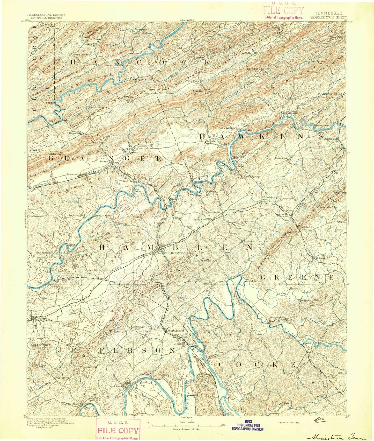
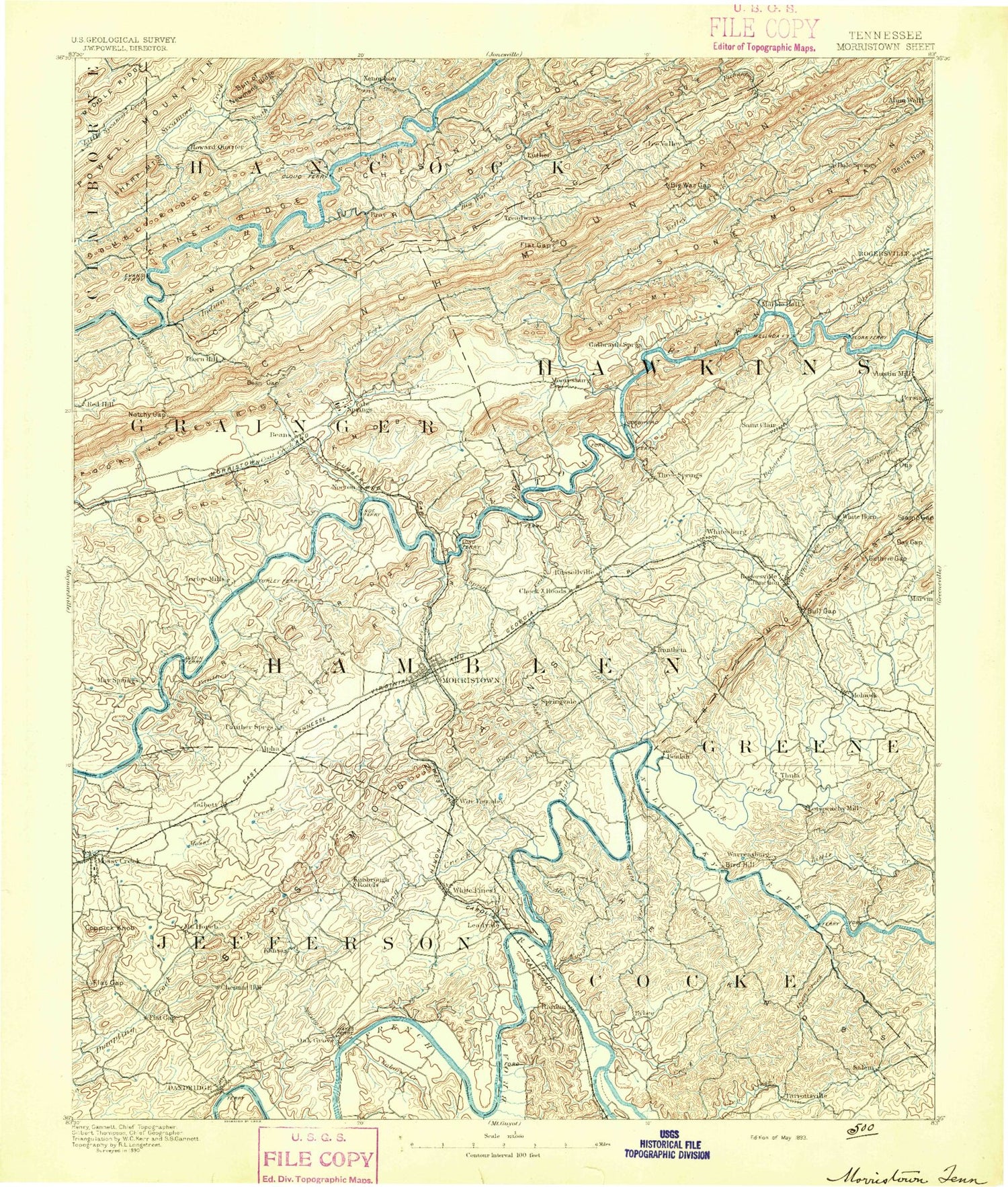
Historic 1893 Morristown Tennessee 30'x30' Topo Map
Couldn't load pickup availability
Historical USGS topographic map of Morristown in the state of Tennessee. Scale: 1:125000. Print size: 17" x 24"
This map was published in 1893 and is in the following counties: Claiborne, Cocke, Grainger, Greene, Hamblen, Hancock, Hawkins, Jefferson.
The map contains contour lines, roads, rivers, towns, streams, and lakes. Printed on high-quality waterproof paper with UV fade-resistant inks.
Contains the following named places: Pigeon River, Yellow Branch, Alumwell, Big Sycamore Creek, Brier Creek, Bulls Gap, Byrd Creek, Caney Ridge, Chestnut Ridge, Clinch Mountain, Coldsprings Branch, Copper Ridge, Lick Creek, Little Valley, Morristown, Newman Ridge, River Ridge, River Ridge, Shepherd Branch, Shields Creek, Shields Ridge, Short Mountain, Short Ridge, Skaggs Creek, Skaggs Ridge, Skipper Creek, Skulley Bluff, Slate Creek, Slop Branch, Snake Hollow, Snow Hollow, Solomon Island, South Fork Sycamore Creek, Spoon Hollow, Spring Creek, Spring Creek, Spring Ridge, Springs Branch, Stamp Gap, Stanifer Pond, Statem Gap, Steele Island, Stock Creek, Stone Mountain, Stone Mountain Branch, Stone Mountain Gap, Stony Fork, Stony Point Knob, Stubblefield Creek, Stubblefield Hollow, Sugar Hollow Pond, Sugartree Hollow, Summit, Sunset Hills, Swan Creek, Sycamore Creek, Taddling Branch, Talley Hollow, Tarter Branch, Taylor Gap, The Country Club, The Narrows, Thomas Pond, Thompson Creek, Three Forks Branch, Three Springs Dock, Tigertown, Tip Gap, Town Knobs, Troublesome Hollow, Troublesome Ridge, Turkey Creek, Union Heights, Valley Creek, Valley Home, Valley Springs Minnow Farm, Wa-Ni Village, Walker Branch, Walker Branch, Walker Knob, War Branch, War Branch, War Creek, War Ridge, Ward Gap, Webb Hollow, West Fork Creek, White Cliff, Whitehorn Creek, Wildcat Hollow, Wildcat Hollow, Wilder Branch, Williams Branch, Willis Hill, Wolf Creek, Wolfe Branch, Allen Hollow, Alpha Heights, Anderson Bend, Annex Creek, Arnott Branch, Aunt Jane Hollow, Avondale Springs, Bailey Branch, Baker Hollow, Beal Pond, Bean Station, Thorn Hill Gap, Beech Bottoms, Beech Ridge, Bell Hill, Bell Hollow, Bell Quarry, Belmont, Bent Creek, Big Creek, Big Creek, Big Hollow, Big Hollow Hill, Big Ridge, Big Spring Branch, Big War Creek, Big War Gap, Bingham Branch, Bird Hill, Black Creek, Black Oak Doock, Black Oak Grove Cabin Area, Black Oak Park, Boyd Knob, Boyd Knob Hollow, Briar Fork, Briar Thicket, Bridges Hollow, Broken Valley, Brooks Hollow, Brown Branch, Brushy Ridge, Brushy Ridge, Bryant Branch, Buck Hollow, Buck Lick Hollow, Buckner Hollow, Buffalo Wallow Branch, Bulls Gap, Bunches Trace, Burke Hollow, Butler Hollow, Campbell Mountain, Caney Creek, Caney Fork, Caney Fork, Caney Valley, Cantwell Valley, Carter Branch, Cave Pond, Cedar Creek, Cedar Creek, Cedar Hill Dock, Cedar Springs Creek, Cedar Valley, Central Point, Chaney Branch, Cherokee Dock, Cherokee Lake, Chestnut Flats Gap, Chestnut Grove, Chinquapin Mountain, Christian Hollow, Chucky Bend, Cluck Ponds, Colliers Corner, Collins Ridge, Comby Ridge, Condry Bend, Conn Dock, Cool Branch, Cool Branch, Cool Hollow, Cooper Hollow, Corn Hollow, Cornette Dock, Cove Hollow, Coy Zinc Mine, Craneneck Bend, Crider Creek, Crockett Ridge, Cunningham Hollow, Dalton Knob, Dalton Lake, Dandridge, Dandridge Dock, Dandridge Municipal Park, Darrow Hollow, Darrow Mill, Davis Hollow, Davis Ridge, Devils Nose, Diamond Creek, Dickenson Pond, Doubling Mountain, Draw Rock, Dry Branch, Dry Branch, Dry Branch, Dry Branch, Dry Branch, Dry Gully Branch, Dry Hollow, Dry Valley, Duck Hollow, Robinson Creek, Easterly Pond, Eckel Branch, Eldridge Branch, Enka Dam, Evans Knob, Fall Creek, Fall Rock Branch, Fancher Branch, Fernwood, Finley Gap, Flat Creek, Flat Gap, Flat Gap, Flat Gap, Flat Gap, Flat Gap Creek, Flat Woods, Flea Ridge, Fork Island, Forked Deer Creek, Fowler Grove Creek, Fox Branch, Fox Hollow Branch, French Broad