
MyTopo
Historic 1887 Mound City Kansas 30'x30' Topo Map
Couldn't load pickup availability
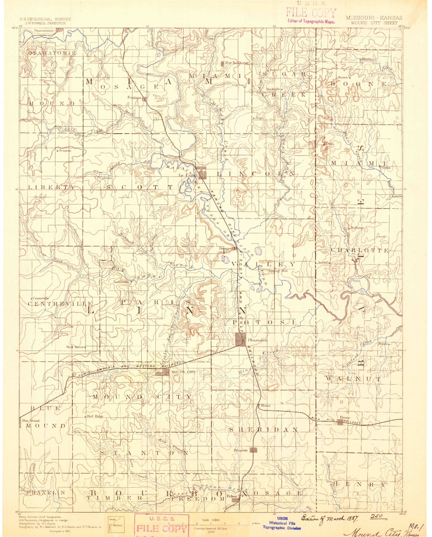
Historical USGS topographic map of Mound Cityin the states of Kansas, Missouri. Scale: 1:125000. Print size: 16" x 24"
This map was published in 1887 and is in the following counties: Bates, Bourbon, Cass, Linn, Miami, Vernon.
The map contains contour lines, roads, rivers, towns, streams, and lakes. Printed on high-quality waterproof paper with UV fade-resistant inks.
Contains the following named places: Fish Creek, Hickory Creek, Township of Osawatomie, Township of Mound, Township of Liberty, Mound Creek, Beagle, Bangor, Pottawatomie Creek, Jordan Branch, Fontana, Miami County State Park, Hunters Lake, Hushpuckney Creek, Middle Creek, Township of Scott, Township of Miami, Jingo, Township of Sugar Creek, Elm Creek, La Cygne Lake, North Sugar Creek, Township of Lincoln, New Lancaster, Township of Centerville, Davis Creek, North Sugar Creek, Goodrich, Landers Creek, Goodrich Creek, Parker, Cadmus, La Cygne, Hurley Field, Stave Lake, Elm Creek, Twin Springs Creek, Township of Paris, Richland Creek, Turkey Creek, Graveyard Mound, Big Sugar Creek, Boicourt Lake, Township of Valley, Marais des Cygnes Waterfowl Area, Boicourt, Middle Creek, Star Valley School, New Home School, Hog Branch, Massacre Memorial State Park, South Fork Sugar Creek, Sugar Creek, North Fork Little Sugar Creek, South Fork Little Sugar Creek, Buck Creek, Doe Creek, Alexander Branch, Coffeebean Creek, Mound City, Farlinville, Hazel Branch, Turkey Creek, Township of Mound City, Township of Potosi, Pleasanton, Lakeside Park, Pleasanton Lake, Green Valley School, Trading Post, Mine Creek, Muddy Creek, Little Sugar Creek, Mapleton, Baker Branch, Owl Creek, Bell Branch, Bradley Lake, Johnson Lake, Township of Stanton, White School, Lost Creek, Pleasant Valley School, Elk Creek, Indian Creek, Laberdie Creek, East Laberdie Creek, West Laberdie Creek, Township of Sheridan, Fulton, Prescott, Faber Park, Osawatomie, Elm Branch, Township of Osage, Walnut Creek, Miami State Fishing Lake and Wildlife Area, La Cygne State Fishing Lake and Wildlife Area, Miami County State Lake Dam, Miami County State Lake, Parker City Dam, Pleasanton City Lake Dam, Pleasanton Lake Dam, Prescott City Dam, Hidden Valley Lake Dam, Lake De Lago, Lake De Lago Dam, Timber Lake Dam, Timber Lake, Lake Chaparral Dam, Lake Chaparral, Prescott City Lake, Linn County Fairgrounds, Pleasanton City Lake, Sugar Valley Shopping Center, Clever Creek, Moores Branch, Drexel Corner, Dunlay, La Cygne Corner, Critzer, Mantey, Barnesville, Linn County, Mine Creek Battlefield Park, Linn Valley, City of Fontana, City of Fulton, City of Mound City, City of La Cygne, City of Linn Valley, City of Mapleton, City of Parker, City of Pleasanton, City of Prescott, La Cygne Sewer Treatment Plant, Fulton Wastewater Treatment Plant, Prescott Sewer Treatment Plant, Pleasanton Wastewater Treatment Facility, Mound City Wastewater Treatment Plant, Parker Wastewater Treatment Facility, Tanglewood Lakes Wastewater Treatment Plant, Lacygne Industrial Park, Pleasanton Industrial Park, Prescott Transfer Station and Construction Debris Landfill, Linn County Park Campground, Linn County Park Marina, Linn County Speedway, Fontana Wastewater Plant, La Cygne Water Treatment Plant, Linn County Park Wastewater Treatment Plant, Sugar Valley Lakes Golf Club, Deer Trace Golf Course, Marais des Cygnes Massacre State Historic Site, Beachner Grain Elevator Number 19, Beachner Grain Elevator Number 24, Beachner Grain Elevator Number 25, Wade Quarries, Marais des Cygnes National Wildlife Refuge, North Sugar Creek, Hog Branch, Mine Creek, Amoret, Cottonwood Creek, Gillum Creek, Graves Mound, Merwin, Mulberry Creek, Pecan Creek, Plum Branch, Rocky Mound, Spy Mound, Summers Mound, Tolley Creek, Walley Mound, Willow Branch, Worland, Amsterdam, Drexel, Foster, Hume, South Drexel, Mulberry, Rock, Ward, Amos, Rucker, Tiger, Drexel Lake Dam, Drexel Lake, KCS Bridge A-65 Dam, Railroad Lake, Ward Lake Section 7 Dam, Hodges Lake Dam, Rocking Chair Ranch Lake Dam, Drexel City Reservoir South Dam, Drexel City Reservoir South, Rainey Lake, May Lake Dam, May Lake, Boone Lake Dam, Shannon Circle S Ranch Lake Dam, Nelson Lake Dam, Township of Homer, Township of Howard, Township of Walnut, Township of West Boone, Township of West Point, Township of Henry, City of Amoret, City of Amsterdam, Town of Hume, Village of Foster, Village of Merwin, Drexel North Wastewater Treatment Facility, Drexel South Wastewater Treatment Facility, Marais des Cygnes National Wildlife Refuge


