MyTopo
Historic 1907 Mount Adams Washington 30'x30' Topo Map
Couldn't load pickup availability
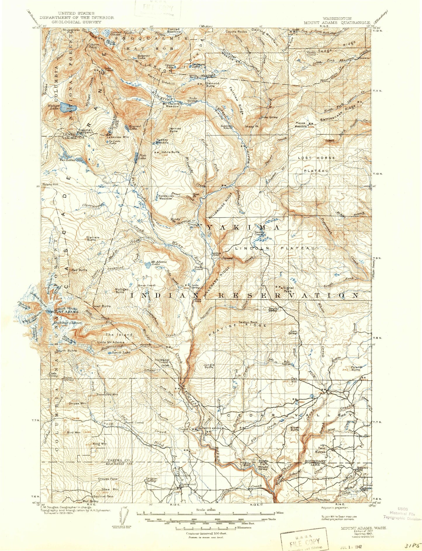
Historical USGS topographic map of Mount Adams in the state of Washington. Scale: 1:125000. Print size: 16" x 24"
This map was published in 1907 and is in the following counties: Klickitat, Lewis, Yakima.
The map contains contour lines, roads, rivers, towns, streams, and lakes. Printed on high-quality waterproof paper with UV fade-resistant inks.
Contains the following named places: Bear Creek, Blue Creek, Borde Flats, Brush Creek, Cedar Creek, Cedar Creek, Cedar Valley, Dry Creek, Elk Creek, Hog Swamp, Joe Creek, Klose Butte, Lost Springs Campground, Lyon Spring, Mike Coon Hillside, Outlet Creek Campground, Outlet Falls, Poland Butte, Pole Creek, Saxton Rock, Schafer Creek, Schafer Pocket, Shamrock Spring, Sheep Creek, Signal Peak, Tepee Creek, Trout Creek, Twin Buttes, West Fork White Creek, White Creek, Klickitat State Fish Hatchery, Signal Peak Ranger Station, Oak Hill, Featherbed Creek, Mill Pond, Smith Butte, Mount Adams, Alpine Camp, Avalanche Valley, Bacon Creek, Battlement Ridge, Beauty Camp, Bench Lake, Big Muddy Creek, Bird Creek Campground, Bird Creek Meadows, Bird Creek Meadows Picnic Area, Bird Lake, Blue Jay Campground, Bluff Lake, Brush Corral, Buck Camp, Bullgrouse Ridge, Bunnell Butte, Butte Meadows, Butte Meadows Creek, Bypass Camp, Caldwell Prairie, Camp Chaparral, Castile Falls, Cedar Swamp, Chaparral Creek, Cirque Lake, Cispus Pass, Clearwater Creek, Cold Creek, Coleman Weedpatch, Conrad Creek, Conrad Glacier, Corral Creek, Lake Corral, Cougar Creek, Cougar Creek Guard Station, Cowboy Parking Lot, Coyote Creek, Coyote Rocks, Crawford Creek, Crescent Glacier, Cress Camp, Crooked Creek, Crooked Creek Falls, Cuitin Creek, Cultus Hole, Cunningham Creek, Dairy Creek, Deer Creek, Devils Gardens, Diamond Butte, Diamond Fork, Diamond Lake, Draper Springs Camp, Dry Creek, East Fork McCreedy Creek, Elkhorn Creek, Esel Point, Fairview Ridge, Fish Lake, Fish Lake Stream, Foggy Flat, Gertrude Lake, Gilbert Peak, Glaciate Butte, Glenwood, Goat Butte, Goat Rocks, Gotchen Creek Guard Station, Gotchen Glacier, Heart Lake, Hellroaring Creek, Hellroaring Ditch, Hellroaring Meadow, Highline Trail, Holdaway Meadow, Howard Lake, Howard Lake Stream, Huckleberry Creek, Huckleberry Creek, Huckleberry Swamp, Hussey Meadow, Icksix Creek, Island Campground, Jennies Butte, Jerusalem Camp, Johns Butte, Jungle Butte, Kesslers Ranch, King Mountain, Kingfish Creek, Klickitat Camp, Klickitat Glacier, Klickitat Meadow, Klickton Divide, Lakeview Mountain, Lava Glacier, LeConte Lake, Lincoln Plateau, Little Mount Adams, Little Muddy Creek, Lost Horse Plateau, Lyman Glacier, Mazama Glacier, McCormick Meadow, McCreedy Creek, McCumber Spring, McDonald Ridge, Meade Glacier, Meadow Butte, Middle Fork McCreedy Creek, Miller Point, Mirror Lake, Mosquito Creek, Mount Adams Lake, Mulligan Butte, Nannie Peak, Nannie Ridge, North Cleaver, North Fork Chaparral Creek, North Fork Dairy Creek, Olney Corral, Outlet Creek, Panther Butte, Panther Creek, Parrott Crossing, Pearl Creek, Peavine Ridge, Petross Creek, Petross Sidehill, Pile Up Creek, Pinegrass Ridge, Piscoe Creek, Piscoe Meadow, Potato Hill Guard Station, Rattlesnake Ridge, Red Butte, Red Butte, Red Saddle, Reservation Creek, Ridge of Wonders, Roosevelt Cliff, Rusk Creek, Rusk Glacier, Sage Flat Ditch, Shadow Lake, Sheep Lake, Sheep Point, Short Trail Camp, Skunk Creek, Snipes Mountain, Snowgrass Flat, Snowplow Mountain, Soda Spring Campground, Soda Spring Creek, South Butte, South Fork Toppenish Creek, Spencer Point, Stout Campground, Suksdorf Ridge, Surprise Lake, Surveyors Creek, Swamp Creek, Swamp Creek, Tenday Creek, The Castle, The Spearhead, Timberline Campground, Trappers Creek, Tree Phones Campground, Two Lakes, Victory Ridge, Walupt Creek, Walupt Lake, Walupt Lake Campground, Walupt Lake Guard Station, Warm Lake, West Fork Klickitat River, Wilson Glacier, Windy Point, Yedlick Creek, Pikers Peak, Walupt Lake Horse Camp, Cold Springs Campground, Panther Creek Lookout, Nannie Peak Lookout, O'Connor Creek, Mill Pond Dam, Yakama Nation Reservation Division