MyTopo
Historic 1904 Mount Aix Washington 30'x30' Topo Map
Couldn't load pickup availability
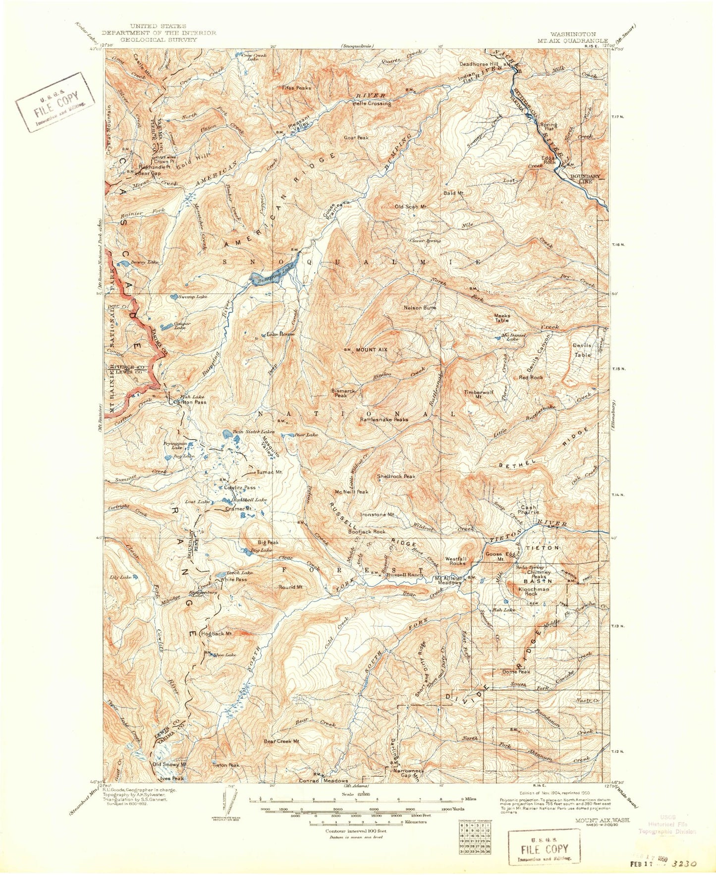
Historical USGS topographic map of Mount Aix in the state of Washington. Scale: 1:125000. Print size: 18" x 24"
This map was published in 1904 and is in the following counties: Kittitas, Lewis, Pierce, Yakima.
The map contains contour lines, roads, rivers, towns, streams, and lakes. Printed on high-quality waterproof paper with UV fade-resistant inks.
Contains the following named places: Ahtanum Guard Station, Ahtanum Meadows, Mount Aix, Allred Creek, American Forks Campground, American Lake, American Ridge, American Ridge Trail, American River, Anderson Lake, Andy Creek, Angel Lake, Apple Lake, Arnesons Peak, Art Lake, Bakeoven Flats, Barnard Saddle, Barton Creek, Basin Lake, Bear Creek, Bear Creek, Bear Creek Mountain, Bear Creek Mountain Trail, Bear Gap, Bear Lake, Bethel Ridge, Big Basin, Big Crow Basin, Big Peak Trail, Bill Lake, Bismarck Peak, Bismarck Trail, Blakenship Lakes, Blankenship Meadows, Blankenship Meadows Trail, Blue Bell Pass, Blue Lake, Blue Slide, Bootjack Rock, Boulder Cave Campground, Boulder Creek, Boundary Lake, Buck Lake, Buck Lake, Buckhorn Meadows, Bullion Basin, Bumping Dam Campground, Bumping Lake, Bumping Lake Trail, Bumping River, Burnt Mountain, Cabin Creek, Camp Creek, Camp Dudley, Camp Fife, Camp Roganunda, Carlton Pass, Carlton Ridge, Carmelita Basin, Cash Prairie, Castle Mountain, Castle Mountain Trail, Catchup Creek, Cedar Creek, Cedar Creek, Cedar Creek, Cedar Lake, Cedar Springs Campground, Cement Basin, Cement Creek, Chain Lakes, Chimney Creek, Chimney Peaks, Chimney Rock, Chipmunk Creek, Christian Camp, Clear Creek, Clear Fork Trail, Clear Lake, Clear Lost Trail, Cliffdell, Clover Flats, Cold Creek, Conrad Lake, Conrad Meadows, Copper City, Copper Creek, Coral Meadow, Corral Creek, Cortright Creek Trail, Cortright Point, Cottonwood Campground, Cougar Creek, Cougar Flat Campground, Cougar Flats, Cougar Lake, Cowlitz Pass, Cowlitz Trail, Cowpuncher Ridge, Coyote Creek, Coyote Lake, Coyote Trail, Crag Lake, Crag Mountain, Cramer Lake, Cramer Lake Trail, Cramer Mountain, Crow Creek Lake, Crow Lake Trail, Crown Point, Dancing Lady Lake, Dark Meadows Trail, Darland Mountain, Dead Hole, Dead Horse Flats, Deadhorse Hill, Deep Creek, Deer Lake, Devil Creek, Devil Creek Falls, Devils Canyon, Devils Horn, Devils Slide Lake, Devils Table, Devils Washbasin, Dewey Lake, Dewey Lake Trail, Discovery Creek, Divide Ridge, Dog Creek, Dog Lake, Dome Peak, Dumbbell Lake, East Fork Short and Dirty Creek, Edgar Rock, Egg Butte, Elizabeth Creek, Elizabeth Lake, Elk Pass, Elkhorn Creek, Ewe Neck, Fall Creek, Fifes Creek, Fifes Peaks, Fifes Ridge, Fifes Ridge Trail, Fish Creek, Fish Flats, Fish Lake, Fish Lake, Flat Iron Lake, Foundation Ridge, Fox Meadow, Fryingpan Lake, Fryingpan Mountain, Ginnette Lake, Glass Creek, Goat Creek, Goat Creek Trail, Goat Lake, Goat Lake, Goat Peak, Goat Ridge, Gold Creek, Gold Hill, Golden Meadow, Goose Egg Mountain, Goose Prairie, Goose Prairie Trail, Granite Creek, Granite Lake, Green Lake, Greens Pocket, Grey Creek, Grey Creek Campground, Grouse Heaven, Hacket Canyon, Halfway Flat Campground, Hall Creek, Hause Creek, Hause Creek Campground, Hawkeye Point, Hayden Pass, Haystack Rock, Hell Creek, Hell Lake, Hen Skin Lake, Henry Lake, Hill Lake, Hindoo Creek, Hogback Mountain, Hogback Ridge, Hogback Trail, Horse Creek, Horse Ridge, Horsetail Falls, Indian Creek, Indian Creek Campground, Indian Creek Meadows, Indian Creek Trail, Indian Flat Campground, Ironstone Mountain, Ironstone Mountain Trail, Ives Peak, Jayhawk Flats, Jess Lake, Jug Lake, Jug Lake Trail, Jumpoff Meadows, Kamiakan Butte, Kettle Creek, Kettle Lake, Kincaid Lake, Kincaid Trail, Kitten Creek, Kloochman Rock, Knuppenburg Lake, Lake Basin, Leech Lake, Lightning Lake, Lily Basin Trail, Lily Lake, Lily Lake, Lindsay Campground, Little Bald Mountain, Little Cougar Lake, Little Crow Basin, Little Hindoo Creek, Little Lake, Little Naches Campground, Little Naches River, Little Snow Lake, Little Wildcat Creek, Little Wildcat Trail, Lodgepole Campground, Long Creek