MyTopo
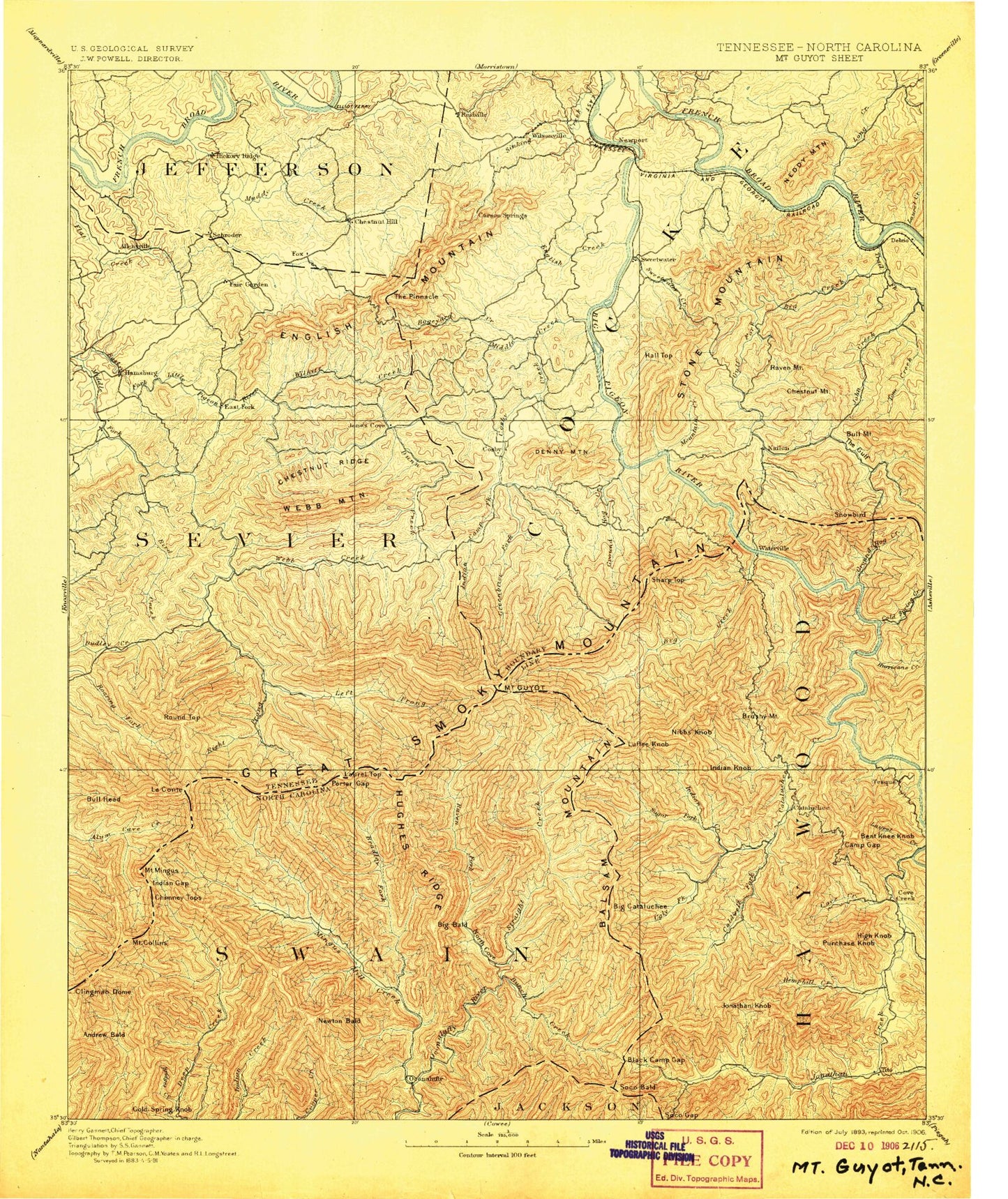
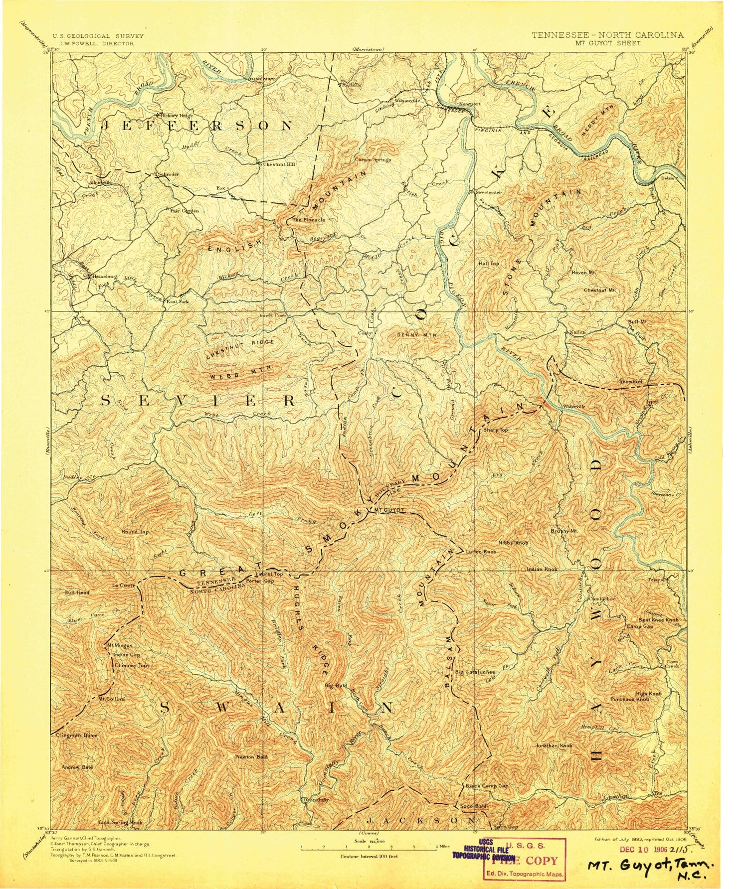
Historic 1893 Mount Guyot Tennessee 30'x30' Topo Map
Couldn't load pickup availability
Historical USGS topographic map of Mount Guyot in the state of Tennessee. Scale: 1:125000. Print size: 17" x 24"
This map was published in 1893 and is in the following counties: Cocke, Haywood, Jackson, Jefferson, Sevier, Swain.
The map contains contour lines, roads, rivers, towns, streams, and lakes. Printed on high-quality waterproof paper with UV fade-resistant inks.
Contains the following named places: Camel Gap, Davenport Gap, Deep Gap, Flat Ridge, Left Fork Deep Creek, Low Gap, Turkey Gap, Indian Gap, Laurel Top, Mount Sequoyah, Newfound Gap, Wildcat Top, Eagle Rocks, Old Black, Cammerer Ridge, Mount Cammerer, Balsam Mountain, Charlies Bunion, Harmon Den Mountain, Masa Knob, Peaked Knob, Pecks Corner, Snowbird Mountain, Tricorner Knob, Mount Ambler, Mount Collins, Mount Guyot, Mount Kephart, Mount Love, Big Ridge, Brown Gap Creek, Copeland Creek, Emerts Cove, Rich Mountain, Sheep Pen Branch, Shell Mountain, Shields Mountain, Short Mountain, Sinking Creek, Sisk Island, Slatey Branch, Sloan Branch, Smoky Mountain Golf Course, Snag Branch, Snag Mountain, Snake Den Mountain, Snakeden Ridge, Snakefeeder Branch, South Fork Bogard Creek, Sowbed Branch, Spicewood Branch, Split Gap, Splitwood Branch, Spurgeon Hollow, Stanley Cliff, Stillhouse Hollow, Stinnett Gap, Styx Branch, Sugar Camp Hollow, Sugar Cove, Sugar Hollow, Sugarland Mountain, Sunup Knob, Surry Fork, Susong Island, Swader Hollow, Sweet Ridge, Talton Gap, Tannery Island, Tater Knob, Tattle Branch, Teague Branch, Teds Branch, Texas Creek, The Bench, The Boulevard, The Glades, The Jumpoff, The Lookoff, The Loop, The Pinnacle, The Sawteeth, The Shinbone, The Sink, Timothy Creek, Tobes Creek, Tomahawk Prong, Toper Ridge, Trantham Hollow, Trillium Branch, Trillium Gap, Trout Branch, Tudor Hollow, Tumbling Branch, Turkey Gap, Turkey Rock, Twin Creek, Tyrant Branch, Valentine Branch, Vinson Island, Walker Camp Prong, Walnut Grove Branch, Warden Branch, Weaver Dock, Webb Creek, West End, West Prong Bird Creek, Whitesprings Branch, Wilhite Creek, Wilson Branch, Wilson Falls, Yellow Breeches Creek, Yellow Spring Gap, Youngblood Branch, Allen Branch, Alum Cave Creek, Alum Gap, Anakeesta Knob, Anakeesta Ridge, Anderson Branch, Arch Rock, Atchley Branch, Bailey Town, Baker Branch, Bald Top Ridge, Ball Creek, Bear Branch, Bear Branch, Bear Wallow Hollow, Bearpen Hollow, Beech Flats, Bennett Branch, Betsy Branch, Big Flat Ridge, Big Hill, Big Ridge, Birchfield Gap, Bird Creek, Black Fox Branch, Blackgun Gap, Blazed Pine Ridge, Boogertown Gap, Boulevard Prong, Breeden Branch, Breeden Branch, Brown Mare Branch, Brushy Mountain, Buck Fork, Buck Ridge, Buckeye Lead, Buckhorn Creek, Bull Mountain Gap, Butler Branch, Calder Ridge, Camel Hump Creek, Camel Hump Knob, Camel Hump Mountain, Cameron Branch, Camp Hollow, Camp Moss Creek, Campbell Branch, Canupp Branch, Carson Springs, Cartertown, Castle Heights, Cat Stairs, Cat Stairs Branch, Cates Creek, Cedar Bluff, Chambers Branch, Chapman Lead, Chapman Prong, Cherokee Orchard, Chestnut Mountain, Chestnut Ridge, Chicken Hollow, Chimney Tops, Chimneys Campground, Chucky Creek, Chute Branch, Clark Branch, Clear Creek, Cliff Branch, Cloverfield Branch, Cole Creek, Cole Creek, Collins Gap, Copeland Divide, Copper Gap, Copperhead Branch, Cosby Knob, Cowden Hollow, Crawley Pond, Cricket Branch, Crumb Hollow, Cut Ridge, Dan Top, Darky Branch, Deep Gap, Deep Gap Creek, Denton Hollow, Devils Den, Dixon Branch, Dixon Mountain, Dockery Branch, Dooley Hollow, Douglas Estates, Douglas Lake, Dry Branch, Duds Branch, Dugan Branch, Dunn Creek, East Prong Bird Creek, Eastport, Edgemont, Edwina, Elvin Branch, English Creek, English Mountain, Enloe Hollow Branch, Evans Creek, Fain Cove, Fair Garden, Fall Branch, Falls Branch, False Gap Prong, Fern Branch, Fern Springs Branch, Finchum Hollow, Fine Branch, Flat Branch, Flint Branch, Fork Ridge, Frye Branch, Gibson Hollow, Glade