MyTopo
Historic 1927 Mount Hood Oregon 30'x30' Topo Map
Couldn't load pickup availability
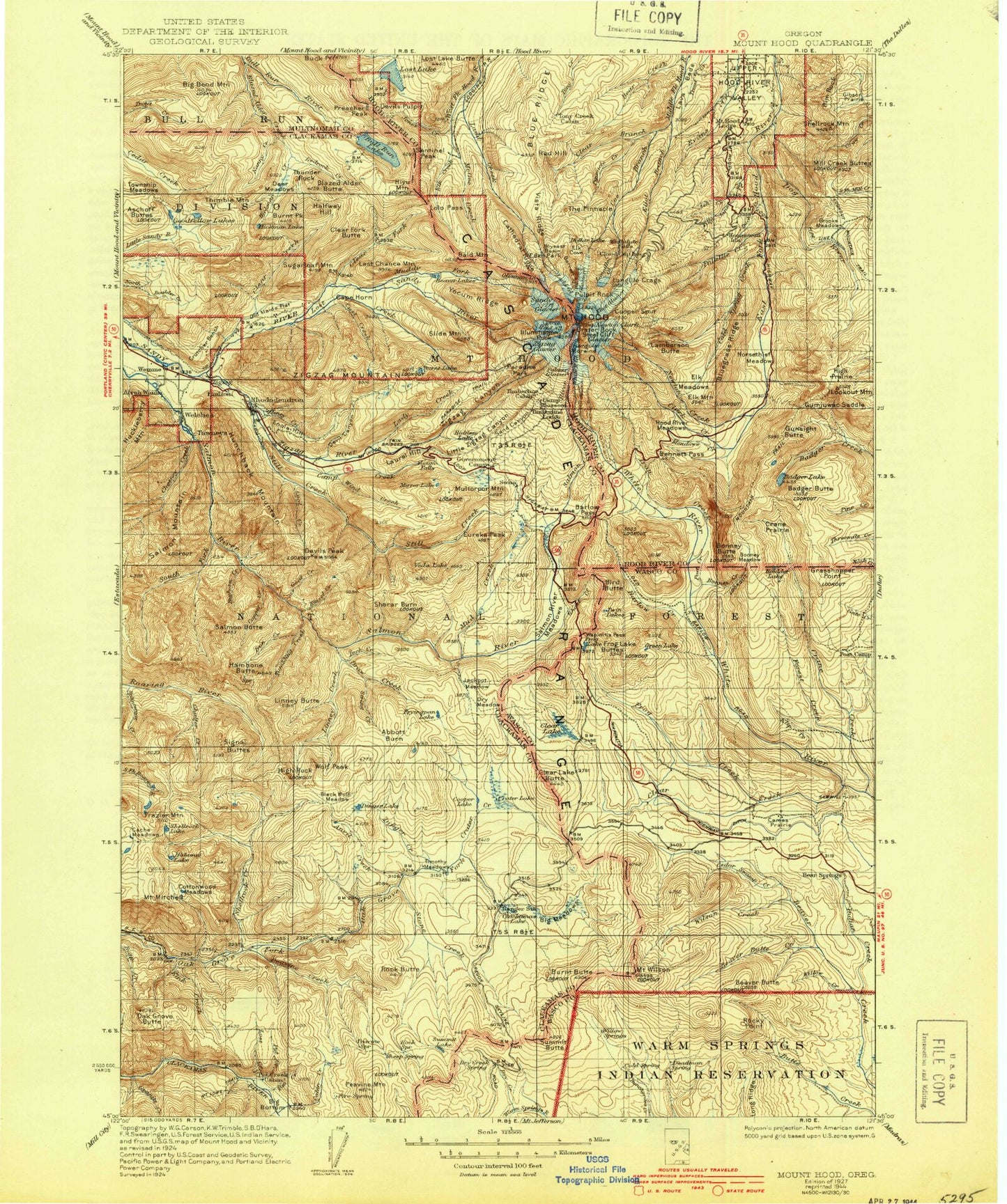
Historical USGS topographic map of Mount Hood in the state of Oregon. Scale: 1:125000. Print size: 17" x 24"
This map was published in 1927 and is in the following counties: Clackamas, Hood River, Multnomah, Wasco.
The map contains contour lines, roads, rivers, towns, streams, and lakes. Printed on high-quality waterproof paper with UV fade-resistant inks.
Contains the following named places: Frog Creek Ditch, Newton Clark Glacier, Salmon Lake, Frazier Turnaround Campground, Rock Lakes Basin, Cold Springs Creek, Dobry Point, Snive Creek, Chief Creek, Abbott Burn, Anvil Lake, Meditation Point, High Rock Creek, Abbot Pass, Alpine Recreation Site, Alpine Ski Trail, Anvil Creek, Arrah Wanna Trail, Aschoff Buttes, Ash Creek, Badger Butte, Badger Lake, Bald Mountain, Bald Mountain Shelter, Barlow Butte, Barlow Creek, Barlow Guard Station, Barlow Pass, Barlow Ridge, Barrett Spur, Basin Point, Bear Creek, Bear Creek, Beaver Butte, Beaver Butte Creek, Beaver Creek Driveway, Bedrock Creek, Bennett Pass, Big Bend Mountain, Big Bend Trail, Big Bottom, Big Meadows, Bighorn Creek, Bird Butte, Black Wolf Meadows, Blazed Alder Butte, Blazed Alder Creek, Blazed Alder Way Trail, Blue Box Pass, Blue Bucket Trail, Blue Lake, Blue Ridge, Bluegrass Ridge, Bonanza Trail, Bonney Butte, Bonney Creek, Bonney Meadows, Bonney Meadows Trail, Boomer Creek, Bottle Prairie, Boulder Lake, Boulder Lake Trail, Boulder Lake Way Trail, Boulder Point, Brooks Meadow, Bruin Run Creek, Buck Creek, Buck Creek, Buck Creek Trail, Buck Draw, Buck Lake, Buck Lake Trail, Buck Peak, Buckskin Butte, Bull Run Lake Trail, Burnt Lake, Burnt Lake Trail, Burnt Peak, Butcher Knife Ridge, Butcher Knife Peak, Buzzard Point, Cabin Creek, Cache Meadow, Cairn Basin, Caldwell Creek, Camas Creek, Camas Prairie, Camp Arrah Wanna, Camp Creek, Camp Creek Recreation Site, Camp Windy Recreation Site, Canyon Creek, Cape Horn, Cast Creek, Cast Creek Trail, Cast Lake, Cat Creek, Catalpa Lake, Cathedral Ridge, Cedar Swamp, Cedar Swamp Creek, Chitwood Trail, Clackamas Lake, Clackamas Lake Recreation Site, Clark Creek, Clear Branch, Clear Creek, Clear Creek, Clear Creek Ditch, Clear Creek Crossing Recreation Site, Clear Creek Way Trail, Clear Fork, Clear Fork Butte, Clear Lake, Clear Lake Butte, Cloud Cap Saddle Recreation Site, Coe Branch, Coe Glacier, Coffman Camp Trail, Cold Spring Creek, Collins Lake, Compass Creek, Cooks Meadow, Cool Creek, Cool Creek Trail, Cooper Creek, Cooper Spur, Cooper Spur Ski Trail, Copper Creek, Cot Creek, Cottonwood Meadows, Cottonwood Meadows Trail, Cougar Creek, Boulder Creek, Crane Prairie, Crater Creek, Crater Rock, Crutcher Bench, Crystal Spring Creek, Culvert Creek, Dahl Pine, Deer Meadows, Devil Canyon, Devils Canyon Trail, Devils Half Acre Meadow, Devils Kitchen, Devils Lake, Devils Meadow Campground, Devils Peak, Devils Pulpit, Dinger Creek, Dinger Creek Trail, Dinger Lake, Doe Creek, Dog River, Dog River Trail, Dollar Lake, Draw Creek, Driveway Trail, Dry Creek, Dry Meadow, Dumbbell Lake, East Fork Salmon River, East West Trail, East Zigzag Mountain Trail, Echo Point, Eden Park, Eliot Branch, Eliot Glacier, Elk Cove, Elk Creek, Elk Grove Trail, Elk Meadows, Elk Meadows Trail, Elk Mountain, Engineers Creek, Enid Lake, Enola Hill, Eureka Peak, Eureka Peak Trail, Faubion, File Butte, Fir Tree Creek, Flag Mountain, Flag Mountain Trail, Flag Point Trail, Cedar Creek, Forest Creek Trail, Frazier Mountain, McNeil Recreation Site, Frog Creek, Frog Creek Trail, Frog Lake, Frog Lake Buttes, Frying Pan Lake, Kelley Creek, Ghost Creek, Ghost Ridge, Gibson Prairie, Glade Ski Trail, Glisan Glacier, Gnarl Ridge Trail, Goat Creek, Gone Creek Recreation Site, Goodfellow Lakes, Granite Creek, Grasshopper Point, Green Lake, Green Lake Creek, Grindstone Recreation Site, Gumjuwac Creek, Gumjuwac Saddle, Gunsight Butte, Halfway Hill, Hambone Butte, Hambone Trail, Hellroaring Creek, Henry Creek, Hickman Butte, Hickman Creek, Hickman Lake, Hideaway Lake, Hidden Lake, Hidden Lake Trail, High Prairie, High Rock, High Rock Spring Recreation Site, Hiyu Mountain, Hood River Meadows, Hood View Recreation Site, Mount Hood, Horkelia Meadow, Horseshoe Creek, Horseshoe Ridge, Horseshoe Ridge Trail, Horsethief Meadows