MyTopo
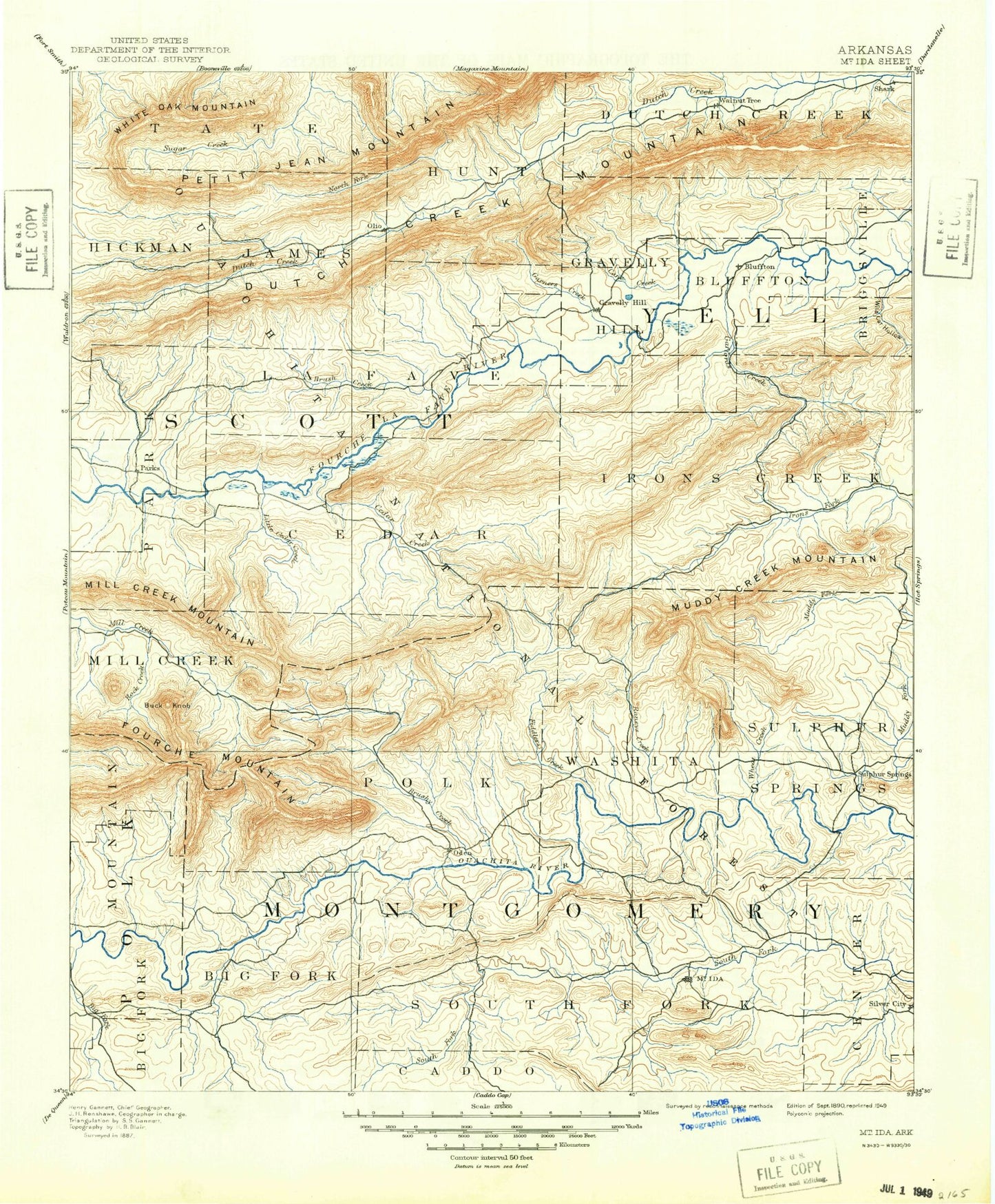
Historic 1890 Mount Ida Arkansas 30'x30' Topo Map
Couldn't load pickup availability
Historical USGS topographic map of Mount Ida in the state of Arkansas. Scale: 1:125000. Print size: 18" x 24"
This map was published in 1890 and is in the following counties: Montgomery, Polk, Scott, Yell.
The map contains contour lines, roads, rivers, towns, streams, and lakes. Printed on high-quality waterproof paper with UV fade-resistant inks.
Contains the following named places: Brantley Ranch Creek, Cut-Off Slough, Big Brushy Recreation Site, Chasewood Landing, Gaston, Gibbs, Mauldin, Mimosa, Owley, Ruble, Sweethome, Twin Creek Use Area, Union Hill, Buck Knob, Cardiff, Forester, Lone Hollow Creek, Mill Creek Recreation Area, Selkirk Lake, Union Hill, Fourche Valley, Pea Ridge, Wildcat Creek, Township of Center, Township of Washita, Township of Pencil Bluff, Township of Cedar, Township of Hunt, Township of James, Township of Jones, Township of La Fave, Township of Lamb, Township of Little Texas, Township of Mount Pleasant, Township of Parks, Township of Tate, Montgomery County, Township of Bluffton, Township of Briggsville, Township of Dutch Creek, Township of Gravelly Hill, Township of Herring, Township of Ions Creek, Abbot Mountain, Alder Creek, Allen Creek, Allen Creek, Bates Hollow, Bear Cave Prong, Bear Creek, Bear Den Mountain, Bear Wallow Prong, Beaver Slough, Bed Creek, Bee Knob, Bee Mountain, Bee Suck Mountain, Big Cedar Creek, Big Cedar Creek, Big Fork, Big Hill Creek, Big Round Top Mountain, Bill Hunt Mountain, Blagg Hollow, Blagg Ridge, Blowout Mountain, Blue Hole Hollow, Bluffton, Bogus Ridge, Bogus Ridge, Bolan Creek, Boston Creek, Brantley Mountain, Bread Tray Hollow, Briscoe Creek, Brush Creek, Brush Ridge, Big Brushy Creek, Brushy Creek Mountain, Brushy Knob, Brushy Mountain, Brushy Mountain, Brushy Mountain, Buck Ridge, Buddys Landing, Callahan Gap, Callahan Knob, Camp Buck Creek, Cane Creek, Caney Creek, Carely Mountain, Castle Ridge, Catalpa Creek, Cedar Branch, Cedar Cabin Mountain, Cedar Creek, Cedar Creek, Cedar Creek, Cedar Ridge, Chalybeate Mountain, Chalybeate Mountain, Chalybeate Spring Hollow, Chalybeate Springs, Chicken Hollow, Chop Off Mountain, Chula, Chula Mountain, Clear Branch, Clear Creek, Coffee Pot Hollow, Coon Branch, Cow Creek, Cow Creek, Craft Creek, Crump Creek, Cudd Creek, Curtis Mountain, Deer Creek, Dry Fork, Dry Fork, Dutch Creek Mountain, East Fork Twin Creek, East Gafford Creek, East Spiller Creek, East Weaver Creek, Eli Branch, Fiddlers Creek, Fourmile Creek, Fourmile Mountain, Freedom Mountain, Fulton Branch, Gabbert Mountain, Gafford Creek, Ganders Peak, Gardner Mountain, Garner Creek, Gaston Mountain, Gault Branch, Gilbreath Mountain, Goat Knob, Grapevine Mountain, Grassy Flat Creek, Hackberry Creek, Hackberry Mountain, Haney Creek, Harding Ridge, Harold Ridge, Harris Creek, Hart Ridge, Harvey, Haw Branch, Hazel Creek, Henry Branch, Herron Ridge, Hickory Ridge, High Peak, High Point Ridge, Highland, Hog Jaw, Hog Jaw Mountain, Hogan Mountain, Hole in the Ground Creek, Holly Mountain, Honey Cut Gap, Hoover Creek, Hoover Mountain, Hopper Mountain, Hovel Creek, Huckleberry Mountain, Hughes Branch, Hughes Mountain, Hurricane Hollow, Hurricane Ridge, Huse Mire Hollow, Mount Ida, Jeff Summit Mountain, Jennings Branch, Jennings Creek, John Allen Hollow, John Burns Mountain, John Sanders Ridge, Johnson Hollow, Janes Creek, Kagle Branch, Kates Creek, Kelly Creek, Kelly Mountain, Kingdoodle Creek, Kingdoodle Knob, Kitchen Branch, Lackey Bluff, Left Prong Bear Creek, Lick Branch, Lick Branch, Linn Barker Mountain, Little Brushy Creek, Little Cedar Creek, Little Cedar Creek, Little Flat Branch, Little Joe Creek, Little Nickleson Branch, Little Rainy Creek, Little Round Mountain, Little Round Top Mountain, Little Texas, Lofland Creek, Long Branch, Long Hollow, Long Ridge, Long Ridge, Main Mountain, Martin Creek, Mast Mountain, Mauldin Mountain, McCafferty Hollow, McGill Mountain, McKim Branch, Mill Creek, Mill Creek Mountain, Miller Ranch Creek, Mitchell Branch, Mud Creek, Mud Lick Mountain, Muddy Creek, Muddy Mountain, Muddy Mountain, Murder Creek, Narrow Ridge, Nesbitt Creek, Nickleson Branch, Nola, Norris Hollow, North Fork South Fork Ouachita River, North Prong Brush Creek, Oden, Oil Well Hollow