MyTopo
Historic 1924 Mount Rainier Washington 30'x30' Topo Map
Couldn't load pickup availability
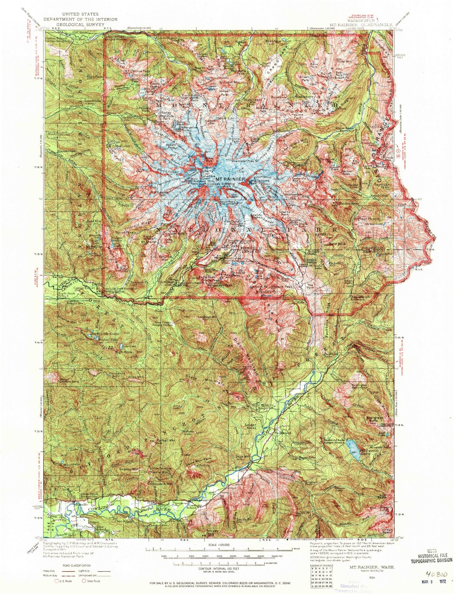
Historical USGS topographic map of Mount Rainier in the state of Washington. Scale: 1:125000. Print size: 16" x 24"
This map was published in 1924 and is in the following counties: Lewis, Pierce, Yakima.
The map contains contour lines, roads, rivers, towns, streams, and lakes. Printed on high-quality waterproof paper with UV fade-resistant inks.
Contains the following named places: Cascade Range, Ada Creek, Adelaide Lake, Affi Falls, Alice Falls, Alki Crest, Allen Mountain, Lake Allen, Angry Mountain, Angry Mountain Trail, Antler Peak, Mount Ararat, Art Lake, Arthur Peak, August Peak, Aurora Lake, Aurora Park, Aurora Peak, Ayance Canyon, Backbone Lake, Backbone Ridge, Backbone Ridge Trail, Baker Point, Bald Rock, Barrier Peak, Basalt Cliff, Bear Park, Bear Prairie, Beargrass Butte, Beaver Bill Creek, Beaver Lake, Bee Flat, Beljica Meadows, Mount Beljica, Berkeley Park, Berry Creek, Berry Peak, Bertha May Lake, Big Creek, Big Creek Campground, Big Creek Trail, Blue Lake, Bluff Lake, Bluff Lake Trail, Boulder Creek, Boundary Creek, Boundary Peak, Boundary Trail, Boundary Trail, Brown Peak, Brownie Creek, Buell Peak, Burnt Park, Burroughs Mountain, Burton Creek, Burton Meadows, Camp Hazard, Canyon Rim View Point, Carbon Glacier, Carbon River Entrance, Carbon River Ranger Station, Carlton Creek, Carter Falls, Castle Peak, Cataract Creek, Cataract Falls, Cave Creek, Cayada Creek, Cedar Flats, Chenuis Creek, Chenuis Falls, Chenuis Lakes, Chinook Creek, Chinook Pass, Christine Falls, Lake Christine, Chutla Peak, Clear Fork Cowlitz River, Clover Lake, Coal Creek, Coal Creek Bluff, Coal Creek Mountain, Cockscomb Mountain, Cold Basin, Colonnade, Columbia Crest, Comet Falls, Copper Creek, Copper Mountain, Cora Lake, Cortright Creek, Cougar Creek, Cougar Gap, Cougar Rock, Cougar Rock Campground, Cougar Rocks, Cowlitz Chimneys, Cowlitz Divide, Crater Creek, Crescent Creek, Crescent Lake, Crescent Mountain, Cress Falls, Crystal Creek, Crystal Lake, Crystal Mountain, Cunningham Creek, Curtis Ridge, Cushman Crest, Dam Creek, Davis Creek, Deadwood Creek, Deception Creek, Deer Creek, Deer Creek, Dege Peak, Denman Falls, Devils Dream Creek, Dewey Creek, Dick Creek, Division Rock, Dixon Creek, Dixon Mountain, Doe Creek, Double Peak, Dry Creek, Dry Creek Pass, Dry Creek Trail, Eagle Cliff, Eagle Peak, East Fork Silver Creek, Echo Cliffs, Echo Rock, Edmunds Glacier, Lake Eleanor, Elizabeth Ridge, Elysian Fields, Emerald Ridge, Emmons Overlook, Ethania Falls, Lake Ethel, Eunice Lake, Falls Creek, Fawn Ridge, Fay Peak, Fir Lake, Fish Creek, Fish Ladder Falls, Fishers Hornpipe Creek, Five Thousand Thirty Trail, Flett Glacier, Florence Peak, Forest Lake, Mount Fremont, Frog Heaven, Frozen Lake, Garda Falls, Garrett Creek, Lake George, Ghost Lake, Giant Falls, Gibbs Lake, Glacier Basin, Glacier Creek, Glacier Island, Glacier Lake, Glacier Lake Trail, Glacier View, Goat Creek, Goat Creek, Goat Dike, Goat Island Rock, Goat Lake, Gobblers Knob, Golden Lakes, Gove Peak, Governors Ridge, Grand Park, Granite Creek, Granite Lake, Grant Creek, Grant Purcell Falls, Grassy Mountain, Green Lake, Green Park, Greenwood Lake, Griffin Mountain, Grove of the Patriarchs, Hager Creek, Hager Lake, Hager Lake Shelter, Hall Creek, Hall Ridge, Hampton Creek, Harrington Rock, Hayden Creek, Heart Lake, Lake Helen, Hidden Lake, High Rock, Hinkle Tinkle Creek, Hopkin Creek, Horse Creek, Howard Peak, Huckleberry Basin, Huntington Berry Patch, Independence Ridge, Ipsut Creek, Ipsut Creek Campground, Ipsut Creek Trail, Ipsut Falls, Ipsut Pass, Iron Mountain, Lake James, Jeanette Heights, Johnson Creek, Johnson Creek, Johnson Lake, Johnson Peak, Jordan Basin, Jordan Creek Trail, Josephine Creek, June Creek, Kautz Cleaver, Kautz Creek, Kautz Glacier, Kenworthy Lake, Kilborn Creek, Kiona Creek, Klapatche Park, Klapatche Point, Klapatche Ridge, Klickitat Creek, Knapsack Pass, Kotsuck Creek, La Wis Wis Campground