MyTopo
Historic 1942 Nantucket Massachusetts 30'x30' Topo Map
Couldn't load pickup availability
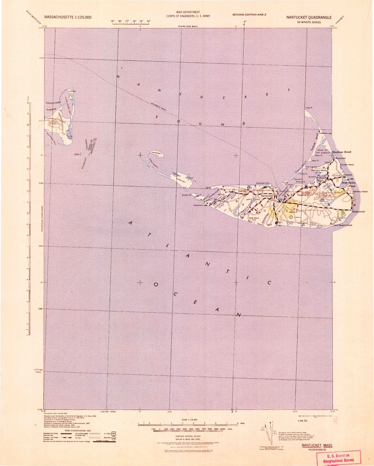
Historical USGS topographic map of Nantucket in the state of Massachusetts. Scale: 1:125000. Print size: 18" x 24"
This map was published in 1942 and is in the following counties: Barnstable, Dukes, Nantucket.
The map contains contour lines, roads, rivers, towns, streams, and lakes. Printed on high-quality waterproof paper with UV fade-resistant inks.
Contains the following named places: Quaise Point, Millbrook Creek, Main Channel, Point Rip, Nantucket Light, Nantucket Aero Light, Cape Poge Light, Nantucket East Breakwater Light, Nantucket Harbor Range Light, Brant Point Light, Nantucket Ferry Slip Light, Tuckernuck Island South East Light, Katama Bay Marshes, Cape Poge Bay Marshes, Loines Observatory, Fishers Landing, Sturgeon Flats, Tom Neck Point, Norton Shoal, Wasque Shoal, Cape Poge Flats, Nantucket County, Shoveful Shoal, Tuckernuck Bank, Tuckernuck Shoal, Hawes Shoal, Halfmoon Shoal, Horseshoe Shoal, Point Rip, Edwards Shoal, Cross Rip Channel, Quampache Bottom, Caleb Pond, Allen Rock, Cape Poge Bay, Cape Poge Elbow, Cape Poge Gut, Chappaquiddick Beach, Chappaquiddick Island, Edgartown Harbor, Hatsett Rock, John Oliver Point, Katama Bay, Katama Point, Little Neck, Long Point, Mill Rock, Monohansett Rock, Norton Point, North Neck, Pease Pond, Cape Poge, Sampson Hill, Simon Point, Sturgeon Flats, Toms Neck, Toms Neck Point, Washaqua Hill, Wasque Point, Wepua Point, West Opening, Whistler Point, East Pond, Eel Point, Esther Island, Madaket Harbor, Muskeget Island, North Pond, Smith Point, Tuckernuck Bank, Tuckernuck Island, Brant Point, Burnt Swamp, Capaum Pond, Cisco, Cisco Beach, Clark Cove, Cliff Beach, Coatue Beach, Coatue Point, Coatue, The Creeks, Dionis Beach, Eel Point Marsh, Fishers Landing, Great Neck, Head of Hummock, Hither Creek, Hummock Pond, Jackson Point, Jeremy Cove, Jetties Beach, Johns Point, Larrabee Swamp, Little Neck, Long Pond, Madaket, Madaket Ditch, Miacomet Pond, Miacomet Rip, Millbrook Swamp, Mioxes Pond, Nantucket, Nantucket Cliffs, No Bottom Pond, North Head Long Pond, North Point, Sunset Hill, Reed Pond, Reedy Pond, Rotten Pumpkin Pond, Sheep Pond, Swain Hill, Trots Hills, Trots Swamp, Warren Landing, Washing Pond, Weweeder Ponds, Whale Rock, White Goose Cove, The Woods, Coskata Beach, Coskata, Coskata Pond, Great Point, Point Rip, Abrams Creek, Abrams Point, Almanac Pond, Altar Rock, Bass Point, First Point, Five Fingered Point, Folger Hill, Folgers Marsh, Forked Pond Valley, Fudge Hill, Gibbs Pond, Madequecham Valley, Monomoy, Pimnys Point, Pocomo, Pocomo Head, Pocomo Meadow, Polpis, Polpis Harbor, Pout Ponds, Quaise, Sauls Hills, Second Point, Shawkemo, Shawkemo Hills, Shimmo, Shimmo Creek, South Shore, Squam Swamp, Surfside, Swains Neck, Third Point, Wigwam Ponds, Wyers Point, Cross Rip Channel, Cross Rip Shoal, Edwards Shoal, Long Shoal, Mutton Shoal, Muskeget Channel, Muskeget Rock, Tuckernuck Shoal, Abnecotants Island, Catos Pond, Clean Shore, Dyleave Swamp, Fulling Mill Creek, The Galls, Gibbs Swamp, The Glades, George Easton Swamps, Goose Pond, The Gut, Island Creek, Little Ram Pasture Point, Long Hill, Long Josephs Point, Mikas Pond, Nanahumas Neck, North Pond, Pest House Shore, Pest House Pond, Peat Hole, Popsquatchet Hills, Poverty Point, Ram Pasture, Round O Swamp, Sauls Pond, Shallow Pond, Shimmo Pond, Smugs Ria, Spotsa Swamp, Stony Brook, Taupawshas Swamp, Town Pasture, Waqutuquaib Ponds, Watts Run, Wigwam Valley, Maxcy Pond, Tom Shoal, Madequecham Pond, Nobadeer Valley, Pocha Pond, Little Mioxes Pond, Nantucket Harbor, Bass Ledge, Cape Poge Flats, Head of the Harbor, Nantucket Sound, Rest House Pond, The Narrows, Wannacomet, Caleb Pond, Shear Pen Pond, Narrow Creek Pond, Nantucket Island, Smooth Hummocks, Trots Hills, Town of Nantucket, Town of Edgartown, Chappomiss Valley, Abiah Folger Franklin Fountain, The Bathtub, Brant Point Racquet Club, Childrens Beach, Commercial Wharf, Greater Light Garden, Jetties Beach Public Tennis Courts, Lily Pond Park