MyTopo
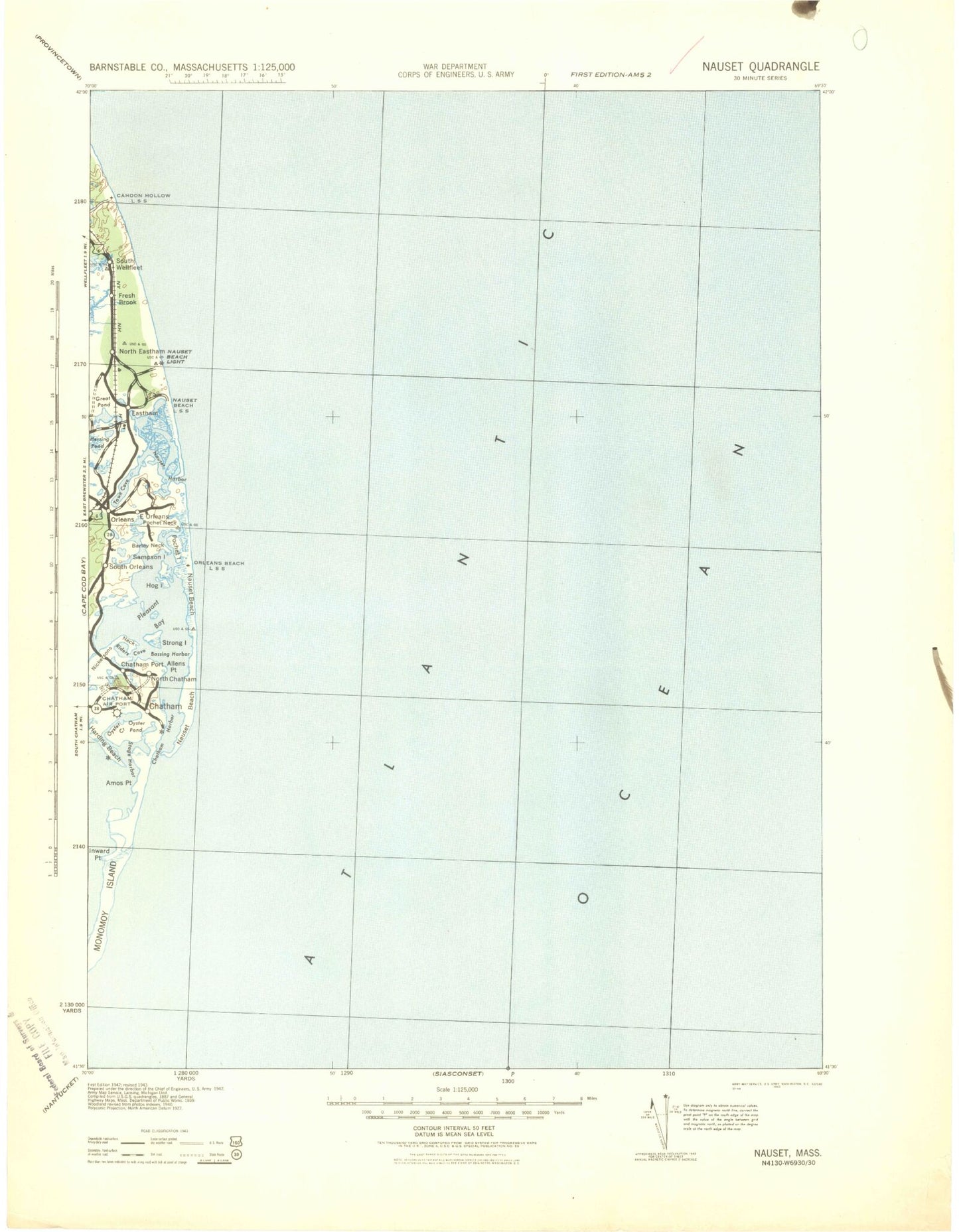
Historic 1942 Nauset Massachusetts 30'x30' Topo Map
Couldn't load pickup availability
Historical USGS topographic map of Nauset in the state of Massachusetts. Scale: 1:125000. Print size: 18" x 24"
This map was published in 1942 and is in the following counties: Barnstable.
The map contains contour lines, roads, rivers, towns, streams, and lakes. Printed on high-quality waterproof paper with UV fade-resistant inks.
Contains the following named places: Wellfleet by the Sea, Money Head, Monomoy Shoals, Nauset Beach Lighthouse, Chatham Aero Light, Chatham Lighthouse, Stage Harbor Light, Chatham Yacht Club, Eastward Ho Country Club, Eldredge Park, Doane Rock Picnic Area, Windmill Park, Pochet Island Marshes, Sampson Island Marshes, Oyster Pond River Marshes, Boat Meadow River Marshes, Rock Harbor Creek Marshes, Herring River Marshes, Blackfish Creek Marshes, Morris Island Marshes, Strong Island Marshes, Mitchell River Marshes, Orleans Shopping Plaza, Orleans Shopping Center, Cranberry Cove Plaza, Hilltop Plaza, Boat Meadow Bog, Wiley Park, The Eastham Mill, Tern Island Sanctuary, Old Grist Mill, Eldridge Point, Portanimicutt, Weesquamsett, Watch Hill, Indian Fort Hill, Fort Hill Trail, Red Maple Swamp Trail, White Crest Beach, Nauset Marsh, Monomoy National Wildlife Refuge, Skiff Hill, Fort Hill, Wash Pond, Nauset Bay Marshes, Monomoy Island Dunes, Camp Wellfleet Dunes, Broken Part of Pollock Rip, Allen Point, Bear Pond, Black Pond, Black Pond, Blue Pond, Chatham, Chatham Bar, Chatham Harbor, Chatham Port, Chatham Roads, Common Flat, Deep Pond, Emery Pond, Fox Hill, Frost Fish Creek, Great Hill, Harding Beach, Little Mill Pond, Little Pleasant Bay, Little Sipson Island, Long Point, Lovers Lake, Perch Pond, Mill Pond, Mitchell River, Morris Island, Muddy Creek, The Narrows, Nickersons Neck, North Chatham, Oyster Pond, Oyster Pond River, Pleasant Bay, Quitnesset, Sarahs Pond, Schoolhouse Pond, Sears Point, Shoal Pond, Sipson Island, Stage Harbor, Stage Island, Stillwater Pond, Strong Island, Tern Island, Toms Neck, Uncle Israels Pond, Uncle Seths Pond, West Chatham, White Pond, Barrier Dunes, Bearse Shoal, Butler Hole, Cahoon Hollow, Cahoon Hollow Beach, Drummer Cove, Fresh Brook, Hammonds Bend, Hospital Pond, Inward Point, Kinnacum Pond, Maguire Landing Beach, Lighthouse Marsh, Monomoy Beach, Newcomb Hollow, Newcomb Hollow Beach, Northeast Pond, Pleasant Point, Salls Drain, Shark Hole, Shooters Island, Silver Spring Brook, Southeast Pond, South Wellfleet, Spectacle Pond, Stone Horse Shoal, Trains Creek, Areys Pond, Barley Neck, Boland Pond, Cedar Pond, Crystal Lake, Depot Pond, Eastham, East Orleans, Frostfish Cove, Gould Pond, Great Pond, Herring Pond, Hog Island, Hog Island Creek, Hopkins Island, Icehouse Pond, Jemima Pond, Kescayo Gansett Pond, Little Pochet Island, Lucy Point, Meeting House Pond, Mill Hill, Mill Pond, Minister Pond, Moll Pond, Namequoit Point, Namequoit River, Nauset Bay, Nauset Harbor, Nauset Heights, North Eastham, Old Field Point, Orleans, Orleans Beach, Paw Wah Pond, Pilgrim Lake, Pochet Island, Pochet Neck, Rachel Cove, The River, Rocky Point, Salt Pond, Salt Pond Bay, Sampson Island, Snow Point, South Orleans, Stony Island, Tonset, Town Cove, Uncle Harvey Pond, Weeset, Widow Harding Pond, Woods Cove, Avalon Point, Davis South Shoal, Old Harbor, Broad Creek, The Neck, Pollock Rip, Nauset Beach, Schooner Bar, Amos Point, Broken Rip, Cannon Hill, Eastward Point, Fresh Brook, Oyster Pond Beach, Broken Part of Pollock Rip, Pollock Rip Channel, Weeset Point, Blue Bill Hole, Broad Creek, Harding Beach Point, Monomoy Shoals, Town of Chatham, Town of Orleans, Buttonbush Trail, Pollock Rip Channel, Aunt Lydias Cove, Bassing Harbor, Blue Bill Hole, Crows Pond, Quanset Pond, Round Cove, Ryder Cove, Stetson Cove, Mill Pond, Town of Eastham, Maguire Landing, Sipson Meadow, Nauset Light Beach, Marconi Beach, Coast Guard Beach, Nauset Marsh Trail, Monomoy Wilderness, Wiley Park Beach, North Monomoy Island, South Monomoy Island, Wellfleet Drive-In