
MyTopo
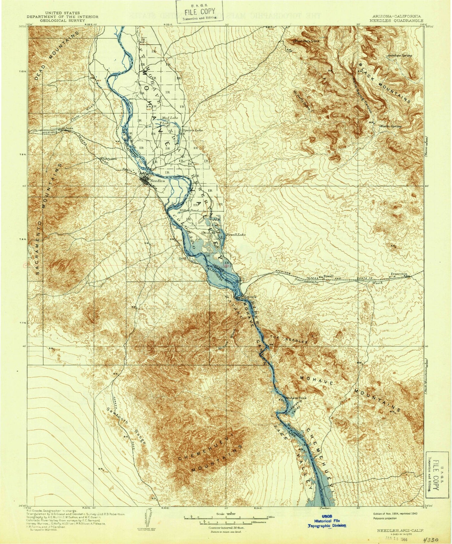
Historic 1904 Needles California 30'x30' Topo Map
Couldn't load pickup availability
Historical USGS topographic map of Needlesin the states of California, Nevada, Arizona. Scale: 1:125000. Print size: 17" x 24"
This map was published in 1904 and is in the following counties: Mohave, San Bernardino.
The map contains contour lines, roads, rivers, towns, streams, and lakes. Printed on high-quality waterproof paper with UV fade-resistant inks.
Contains the following named places: Mohave Canyon, Topock Gorge, Fort Mojave Reservation, Mohave Mountains, Topock Marsh, Bat Cave Wash, Blue Boy Mine, Catfish Bay, Chemehuevi Peak, Chemehuevi Valley, Clear Bay, Devils Elbow, Eagle Pass, Ed Parry Park, Lobecks Pass, Mohave Wash, Monumental Pass, Needles Recreation Area, Park Moabi, Red Rock Falls, Sawtooth Range, Shadow Canyon, Soto Ranch, The Island, Topock Gorge, Trampas Wash, Whale Mountain, Havasu National Wildlife Refuge, Piute Wash, Chemehuevi Mountains, Needles, South Needles Compressor Station, Java, Parker Junction, Snaggletooth, Split Rock, Hacienda Wash, Ross Ranch, Duke Watkins Park, Jack Smith Memorial Park, Manny Morris Park, Needles Marina Park, Needles Municipal Aquatics Center, Needles Municipal Golf Course, Needles Town Center Shopping Center, Nikki Bunch-Franz Flowers Park, Santa Fe Park, Chemehuevi Mountains Wilderness, Dead Mountains Wilderness, Havasu Wilderness, City of Needles, Gourd Wash Pit, Gravel Girty Pit, Needles Pit, Fort Mojave Reservation, Piute Wash, Dead Mountains Wilderness, Black Mesa, Yucca Mine, Warm Springs Canyon, Warm Springs Wash, Adams Mine, Alcyone Mine, Atlantic Drain, Avalon Drain, Beal Ditch, Beal Lake, Black Range Mine, Blankenship Bend, Blankenship Valley, Boulder Mine, Boundary Cone, Castle Rock, Castle Rock Bay, Cathedral Rock, Cimarron Lake, Cone Mine, Cook Mine, Falls Springs Wash, Fivemile Wash, Franconia Wash, Gold Dome Mine, Goose Lake, Green Quartz Mine, Havasupai Wash, Hillside Drain, Jackpot Mine, Jops Harbor, Kiowa Drain, Lazy Boy Mine, Lost Lake, McHeffy Butte, Milltown, Mohave Canyon, Mohave Rock, Nellie Mine, Neptune Wash, Oatman Southern Mine, Oatman Syndicate Mine, Palmtree Wash, Paragon Mine, Peerless Mine, Picture Rock, Powell Peak, Pulpit Rock, River Island, Sacramento Wash, Sage Drain, San Juan Drain, Sandwood Drain, The Glory Hole, The Needles, Threemile Lake, Tipperary Mine, Topock Bay, Topock Gorge, Tumarion Peak, United Oatman Mine, Willow Lake, Wing Mine, Wrigley Mine, Wrigley Peak, Yucca Mine, Ice House Bend, Japanese Slough, Spears Lake, Squaw Beach, Ute Mountain, Fort Mojave Reservation, Catfish Paradise, Fivemile Landing, Franconia, Powell, Topock, Jops Landing, Ute Mountains, Mohave Mountains, Topock Marsh, Chemehuevi Valley, Topock Gorge, Havasu National Wildlife Refuge, Arizona Village, Mesquite Creek, Mojave Ranch Estates, Desert Hills, Mohave Valley, Willow Valley, Havasu Wilderness, Warm Springs Wilderness, City of Lake Havasu City, Bullhead City Division, Picture Rock Window, The Refuge Golf Club, Willow Springs Golf Course, Havasu Recreational Vehicle Resort, Valley Manor Mobile Home Park, Desert Lakes Golf Course, El Rio Golf and Country Club, Sunset Park Mobile Home Park, Desert Hills Estates Recreational Vehicle Park, Desert Hills Estates Mobile Home Park, Los Lagos Golf Club, Aviation Square Industrial Business Park, Havasu Commerce Center, Kiowa Business Park


