MyTopo
Historic 1942 New Bedford Massachusetts 30'x30' Topo Map
Couldn't load pickup availability
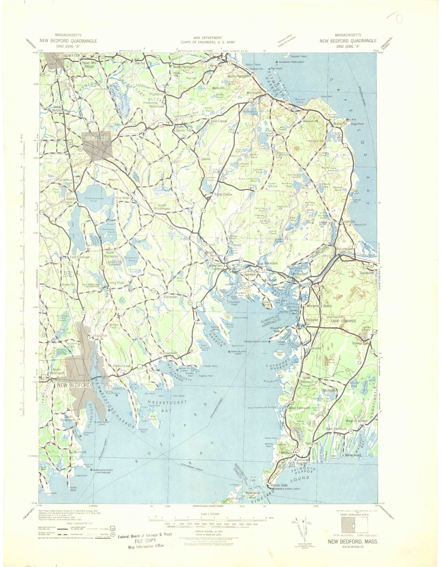
Historical USGS topographic map of New Bedford in the state of Massachusetts. Scale: 1:125000. Print size: 18" x 24"
This map was published in 1942 and is in the following counties: Barnstable, Bristol, Dukes, Plymouth.
The map contains contour lines, roads, rivers, towns, streams, and lakes. Printed on high-quality waterproof paper with UV fade-resistant inks.
Contains the following named places: Cranberry Pond, The Reservoir, Quahog Pond, Eastland Heights, Gibbs Bog, Bourne Pond, Demarest Lloyd Memorial State Park, Apponagansett Point Recreation Area, Jones Park, Hazelwood Park, Cathedral Camp, Buttonwood Park, Cushman Park, Livesey Park, Brooklawn Park, South Shore Marshes Wildlife Management Area, Camp Echo, Rochester Wildlife Management Area, Camp Snipatuit, Rocky Gutter Wildlife Area, Camp Yomechas, Camp Avoda, Reservation Country Club, Hawthorne Country Club, Allendale Country Club, New Bedford Country Club, Massachusetts Correctional Institution, Bedford Industrial Park, Doane Memorial Field, Massachusetts State Pier, New Bedford Community Center, Cedar Swamp Town Forest, Plymouth Harbor Channel, Bird Island South Shoal, Branch, Broadway, Gibbs Rock, Great Sippewisset Rock, Hadley Rock, Hunts Rock Breakwater, Padanaram Breakwater, Pocasset River, Red Ledge, Woods Hole Passage Light, Duxbury Pier Light, South Channel Range Light, Splitting Knife Channel Range Light, Cape Cod Canal Range Light, Waquoit Bay East Jetty Light, Green Pond Harbor Light, Falmouth Inner Harbor Light, Nobaska Point Light, Great Harbor Range Light, Juniper Point Light, Great Harbor Ferry Slip Light, Oceanographic Pier Light, Grassy Island Ledge Light, Cleveland Ledge Light, Cleveland Ledge Channel Range Light, Phinneys Harbor Channel Light, Butler Flats Light, New Bedford West Barrier Light, New Bedford East Barrier Light, Padanaram Breakwater Light, Ned Point Light, Butler Flats Lighthouse, Ashley Park, Morton Park, Camp Norse, Camp Mishannock, Plymouth County Farm, Myles Standish State Forest, Goodwill Park, Marine Park, Camp Baird, Storrow Camp, Camp Dennen, Whitecliff Country Club, Camp Bournedale, Camp Massasoit, Pocasset Golf Club, Woods Hole Golf Club, Plymouth Country Club, Shurtleff Park, Richmond Park, Grassy Island, Molly Cove, Hammonds Cove, Neds Point Light, Charles Neck Point, Gravel Island, Pine Island, Ellisville Landing, Flat Swamp, Little Fivemile Pond, Pier Head, Furnace Pond, Cushmans Pond, Little Snake Pond, Great Snake Pond, Back River Marshes, Pucasset River Marshes, Wings Cove Marshes, Jones River Marshes, Marks Cove Marshes, Little Harbor Marshes, Bourne Cove Marshes, Sippican River Marshes, Muddy Cove Marshes, Sippican Harbor Marshes, Hiller Cove Marshes, Eel Pond Marshes, Mattapoisett Neck Marshes, Mattapoisett River Marshes, West Island Marshes, Sconticut Neck Marshes, Bay View Marshes, Campus Plaza, Berdon Plaza, Fairhaven Plaza, North Hill Plaza, Stop and Shop Center, North Dartmouth Mall, Village Landing, Plimoth Plaza, Manomet Shopping Center, Cranberry Mall, Cranberry Plaza, Wareham Plaza, Gateway Shopping Plaza, Main Street Shopping Center, Falmouth Plaza, Teaticket Plaza, Falmouth Mall, Stewart Bog, Duxbury Pier Lighthouse, Pocasset River, Massachusetts Correctional Institution Forestry Camp, Cleveland Ledge Lighthouse, Kittanset Golf Club, Plimoth Plantation, Myles Standish State Forest, Camp Child, Crane Wildlife Management Area, Fuller Field, Ashumet Holl Reservation, Dexter Grist Mill, The Old Stone Dock, Nobska Lighthouse, Camp Goodwill, Bancroft Landing, Snake Pond Beach, Grover Cleveland House Site, Mill Pond Dam, Red Brook Road Dam, Red Brook Reservoir, Parker Road Bog Dam, Parker Road Pond, Coonamesset Pond Dam, Red Brook Pond Dam, Turner Pond Dam, Turner Pond on High Hill Road Dam, Tinkham Pond Dam, High Hill Reservoir Dam, Acushnet River Reservoir, Hamlin Road Dam, New Bedford Reservoir Dam, Hathaway Pond Dam, Hartley Mill Pond, Hartley Saw Mill Dam, Leonards Pond Dam, Blackmore Pond East Dam, Blackmore Pond West Dam, Sherman Bog Reservoir, Edgewood Trust Number 3 Dam, Horseshoe Pond Dam, Parker Mills Pond Dam, Nye Bog Reservoir, Nye Bog Reservoir Dam, Cross Street Number 2 Dam, Cross Street Bog Reservoir, Bog Pond, Continental Can of America Dam A, Rose Brook Reservoir, Rose Brook Lower Dam, Glen Charlie Pond Dam, Ortolani Reservoir, Ortolani Number Three Dam, Ortolani Number Two Dam, Tihonet Pond Number One Dam, Tihonet Pond Number Two Dam, Tremont Mill Pond, Tremont Mill Pond Dam, Bog Pond, Makepeace Number 1 Dam, Harlow Brook Reservoir, Harlow Brook Number Two Dam, Tobey - Jones Reservoir, Tobey - Jones Reservoir Dam, Harlow Brook Number One Dam, Makepeace Number 2 Dam, Maple Springs Brook Number One Dam, Maple Springs Brook Reservoir, Gibbs Number 3 Dam, Gibbs Number 2 Dam, Harwich Lower Reservoir Dam, Harwich Reservoir, White Island Pond Dam, Harwich Upper Reservoir Dam, Frogfoot Brook Reservoir, Frogfoot Reservoir Dam, Besse Bog Reservoir, Besse Bog Reservoir Dam, Wankinco River Reservoir, Wankinco River Dam Number Two, Pierce Avenue Dam, Pierce Avenue Pond, Weweantic River Reservoir, Slocum - Gibbs Number 1 Dam, Egger Bog Pond, Egger Bog Dam, Golden Field Pond Dam, Slocum - Gibbs Dam Number 2, Mill Pond Dam, Wankinco River Reservoir, Wankinco River Dam Number One, East Head Bog Reservoir, East Head Bog Dam Number One, East Head Bog Dam Number Two, Saint Yues Bog Reservoir, East Head Pond Dam, Lower Sampson Pond, Tremont Street Dam, Atwood Lower Reservoir, Atwood Lower Reservoir Dam, Double Brook Dam