MyTopo
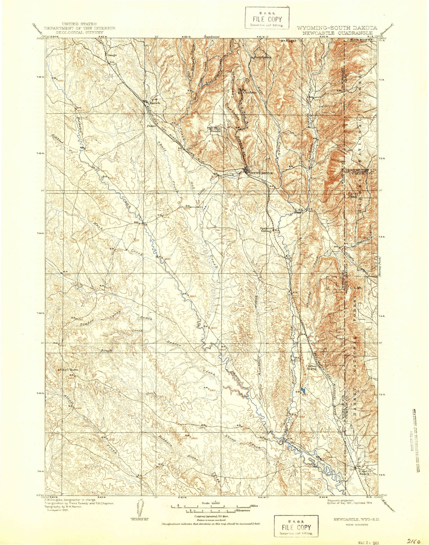
Historic 1901 New Castle Wyoming 30'x30' Topo Map
Couldn't load pickup availability
Historical USGS topographic map of New Castlein the states of Wyoming, South Dakota. Scale: 1:125000. Print size: 17" x 24"
This map was published in 1901 and is in the following counties: Custer, Niobrara, Pennington, Weston.
The map contains contour lines, roads, rivers, towns, streams, and lakes. Printed on high-quality waterproof paper with UV fade-resistant inks.
Contains the following named places: Carr Canyon, Elk Mountains, Gillette Canyon, Kouba Canyon, Line Creek, Sherwood Canyon, Sherwood-Kinney Divide, Stots Canyon, Summit Ridge, Bear Run, Kinney Canyon, Little Bear Run, North Thomson Canyon, Thomson Canyon, Antelope Flats, Blacktail Creek, Breakneck Hill, Buck Pasture Draw, Cambria Creek, Camp Canyon, Cave Spring Canyon, Cemetery Creek, Clifton Canyon, Clifton School, Coal Mine Creek, Dairy Draw, Deadman Draw, Dey Draw, Dry Gypp Canyon, Feralla Draw, Flying V Ranch, Grant Canyon, Gypsum Draw, Hay Creek, Hilton Draw, Johnson Draw, Jumbo Table, Left Fork Blacktail Creek, Lucky Strike Bentonite Mine, M W Lake, M W Ranch, Morris Draw, Newcastle, Rattlesnake Ridge, Rock Canyon, Shank Draw, Spencer Draw, Wyoming Hill, Dakoming, Owens, Spencer, Alkali Butte, Alum Creek, Benhart Draw, Bernard Howell Reservoir, Black Canyon, Blacktail Canyon, Boulden Ranch, Brown Canyon, Cedar Draw, Coyote Canyon, Coyote Draw, Crane Canyon, East Fork Beaver Creek, East Plum Creek, Fanny Peak, Fawcett Draw, Ferguson Canyon, Fiddler Creek, Finn Draw, Fourmile Creek, Fourmile Draw, Frannie Peak, Home Ranch Draw, Klodt Reservoir, L A K Draw, L A K Ranch, Little Oil Creek, Louse Creek, Luce Draw, M Bar Ranch, Morrisey, Mush Creek, Mush Creek Oil Field, North Draw, North Fork Lone Tree Creek, Oil Creek, Osage, Osage Oil Field, Pedro, Pedro Oil Field, Mount Pisgah, Poison Creek, Rats Valley Creek, Rough Creek, Salt Creek, Sand Creek, Scott Canyon, Sheep Creek, Sheldon Canyon, Sixmile Basin, Skull Creek, Slagle Draw, South Beaver Creek, South Draw, South Fork Lone Tree Creek, South Table Draw, Spoon Creek, Stockade Beaver Creek, Sweetwater Creek, Thoeming Draw, Timber Creek, West Fork Fourmile Creek, West Plum Creek, Whitney Draw, Whoopup Creek, Y T Reservoir, Townsend Ranch, Whitney Ranch, Sedgewick Ranch, Engle Ranch, Allen Ranch, Shaw Ranch, Mush Creek Pumping Station, House Dam, House Reservoir, Robbers Roost Dam, Robbers Roost Reservoir, Michaels Dam, Michaels Reservoir, Rosean Dam, Rosean Reservoir, Spencer Dam, L A K Reservoir, Howell Dam, Howell Reservoir, State Dam, State Reservoir, Elliot Dam, Jordon Dam, Jordon Reservoir, Dolores Number 1 Dam, Martin Thompson Dam, Martin Thompson Reservoir, Fillinger Dam, Fillinger Reservoir, Slide Dam, Slide Reservoir, Three Forks Dam, Three Forks Reservoir, Sedgwick Dam, Sedgwick Reservoir, Spencer Number 2 Dam, Spencer Number 2 Reservoir, Mary Ellen Dam, Klodt Dam, Klodt Reservoir, Nelson Dam, Nelson Reservoir, M W Dam, M W Reservoir, Enlargement J L Baird Number 1 Dam, Enlargement Baird Number 2 Dam, Enlargement Baird Number 2 Reservoir, Six Mile Dam, Shostak Dam, Shostak Reservoir, Black Hills Power and Light Dam, Black Hills Power and Light Reservoir, Clifton, Last Chance Filler Pit Mine, Wicker and Baldwin Mine, Elk Mountain Mine, Gerald Barrow Number One Mine, Gerald Barrow Number Two Mine, Gerald Darrow Number Three Mine, Sheep Creek Mine, Foster Mine, L. Shuck Property Mine, Alray Prospect, Lak Reservoir Area Number One Mine, Lak Reservoir Area Number Three Mine, O'Neil Pit, Raby Pit, Sheldon Canyon Mine, Sweet Gravel Pit, Hill View Heights, Newcastle Division, City of Newcastle, Blaine Ranch, Boles Canyon, Buck Spring Canyon, Dewey, Elk Mountains, Gettys Canyon, Gillette Canyon, Holey Flat, Line Creek, Little Flat, Meadow Draw, Neuman-Scott Ranch, Plum Canyon, Red Point, Redbird Canyon, Roby Canyon, Sherwood Canyon, Sherwood-Kinney Divide, Stots Canyon, Sullivan Peak, Summit Ridge, Summit Ridge Lookout, Thomson-Kinney Divide, Triangle Park, Twin Buttes, Wildcat Peak, Moon Campground, Bear Run, Kinney Canyon, Little Bear Run, Moon, North Thomson Canyon, Thomson Canyon, Fanny Peak, Stockade Beaver Creek, Whoopup Creek