MyTopo
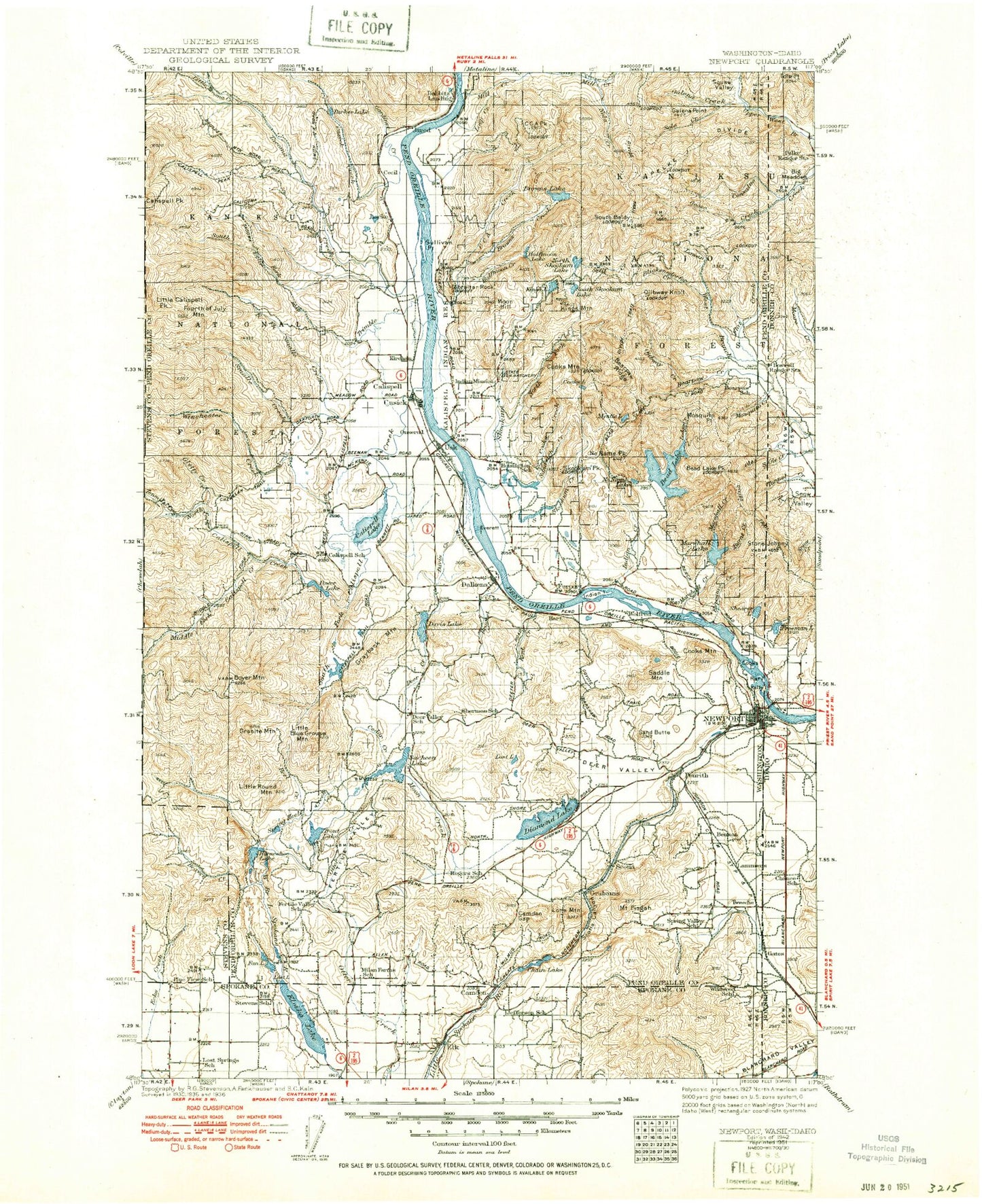
Historic 1942 New Port Washington 30'x30' Topo Map
Couldn't load pickup availability
Historical USGS topographic map of New Port in the state of Washington. Scale: 1:125000. Print size: 18" x 24"
This map was published in 1942 and is in the following counties: Bonner, Pend Oreille, Spokane, Stevens.
The map contains contour lines, roads, rivers, towns, streams, and lakes. Printed on high-quality waterproof paper with UV fade-resistant inks.
Contains the following named places: Flat Creek, Pelke Divide, Tola Creek, Bear Paw Creek, Big H Creek, Blanchard Valley, Consalus Creek, Kelly Island, Mosquito Creek, Ole Creek, Rat Island, Roger Creek, Slough Creek, South Ole Creek, Blanchard Valley, Browns Lake, Camden Gap, Cee Cee Ah Peak, Chain Lake, Conklin Lake, Conklin Meadow, Cooks Creek, Cooks Island, Cooks Lake, Cooks Mountain, Cooks Mountain, Elmer Creek, Horseshoe Lake, Kings Mountain, Little Skookum Creek, Lone Mountain, Mill Creek Point, Moon Hill, Mystic Lake, No Name Lake, No Name Peak, Nola Creek, North Fork Skookum Creek, North Skookum Lake, Pioneer Park, Sandwich Creek, Scotia Canyon, Shearer Lake, Skookum Community Center, Skookum Peak, South Baldy, South Fork Skookum Creek, South Skookum Lake, Split Creek, Spring Valley, Sylvis Creek, Trask Pond, Vances Lake, Kings Lake, Camden, Grahams, Scotia, Tweedie, Penrith, Kings Mountain Lookout, Mill Creek Mountain Lookout, Moon Hill Lookout, Bensons Spur, Ojibway Knoll Lookout, South Baldy Lookout, Newport, Ojibway Knoll, Mount Pisgah, Bear Paw Ridge, Conger Pond, Half Moon Lake, North Skookum Lake Recreational Site, Browns Lake Recreational Site, No Name Lake Recreational Site, South Skookum Lake Recreational Site, Babbitz Lake, Bare Mountain, Bead Lake, Bead Lake Peak, Beaver Creek, Black Lake, Blickensderfer Creek, Blue Lake, Boulder Mountain, Boyer Mountain, Bracket Creek, Brownie Lake, Browns Creek, Brush Mountain, Buck Creek, Burnt Creek, Butch Creek, Calispell, Calispell Creek, Calispell Lake, Calispell Peak Creek, Camp Cowles, Camp Hager, Camp Joubert, Camp Reed, Camp Spaulding, Cedar Creek, Cee Cee Ah Creek, Conger Lake, Cusick, Cusick Creek, Davis Creek, Davis Lake, Deer Creek, Deer Valley, Deer Valley, Deer Valley, Delkena, Diamond Lake, Diamond Lake, Dirty Shirt, East Fork Small Creek, Elk, Eloika Lake, Exposure Creek, Fan Lake, Fertile Valley, Fourth of July Mountain, Furport, Furport Hill, Galena Creek, Galena Point, Gardiner Creek, Gibraltar Rock, Gletty Creek, Goose Creek Point, Graham Creek, Granite Mountain, Grays Landing, Half Moon Creek, Heel Creek, Hemlock Creek, Horseshoe Lake, Indian Community Hall, Indian Creek, Indian Island, Jared, Kent Creek, Knapp Pond, Law Lake, Little Blue Grouse Mountain, Little Calispell Peak, Little Roundtop, Little Tacoma Creek, Locke, Lodge Creek, Loop Creek, Lost Lake, Lower West Branch Priest River, Lake Lucerne, Mallard Marsh, Marshall Creek, Marshall Lake, McCloud Creek, Metcalf Lake, Middle Fork Calispell Creek, Mill Creek, Moon Creek, Mosquito Point, Mountain Meadows Lake, North Fork Calispell Creek, North Fork Goose Creek, North Fork South Fork Tacoma Creek, Ojibway Creek, Panhandle Lake, Parker Lake, Pend Oreille State Park, Pocahontas Bay, Porcupine Pass, Power Lake, Power Peak, Riverside Camp, Rocky Gorge, Rogers Pass, Ruby Mountain, Sacheen Lake, Saddle Mountain, Sand Butte, Sandy Beach, Scotia Valley, Shadow Valley, Silver King Mine, Skookum Creek, Solo Creek, South Fork Calispell Creek, South Fork Small Creek, South Fork Tacoma Creek, Sportsman Pond, Spring Heel Creek, Spring Meadow, Squaw Valley, Tacoma Creek, Tacoma Peak, Tenmile Creek, Trimble Creek, Trout Lake, Usk, West Lodge Creek, Winchester Creek, Winchester Peak, Kalispel Reservation, Lake Newport State Park, Newport Ranger District, Bead Lake Launch, Goose Creek Lookout, Babbitz Landing, Pelke Lookout, Lucky Joe Mine, Mineral Bay Recreational Site, Kirchan, Lucky Joe Mine, Sullivan Point, Cecil, Dalkena, Power Lake Dam, Locke Dam, Kent Meadows Lake Dam, Homestead Lake Dam, Homestead Lake, Ponderosa Lake Dam, Ponderosa Lake, Duncan Dam Number 2, Duncan Dam Number 1, Lake Marney Dam, Yergens and Anselmo Dam Number One, Calispell Lake Dam, Tacoma Sportsman Pond Dam, Conger Lake Dam, Marshall Lake Dam, Reflection Lake North Dam, Kettwig Wildlife Dam