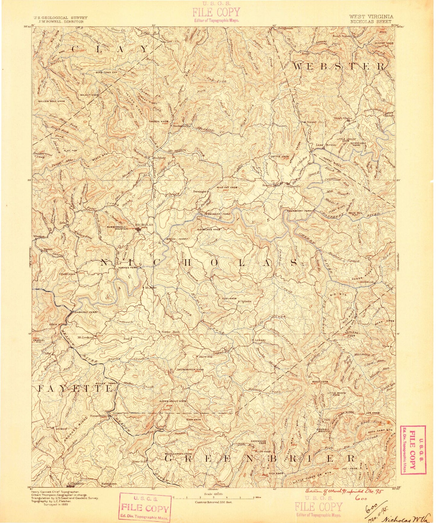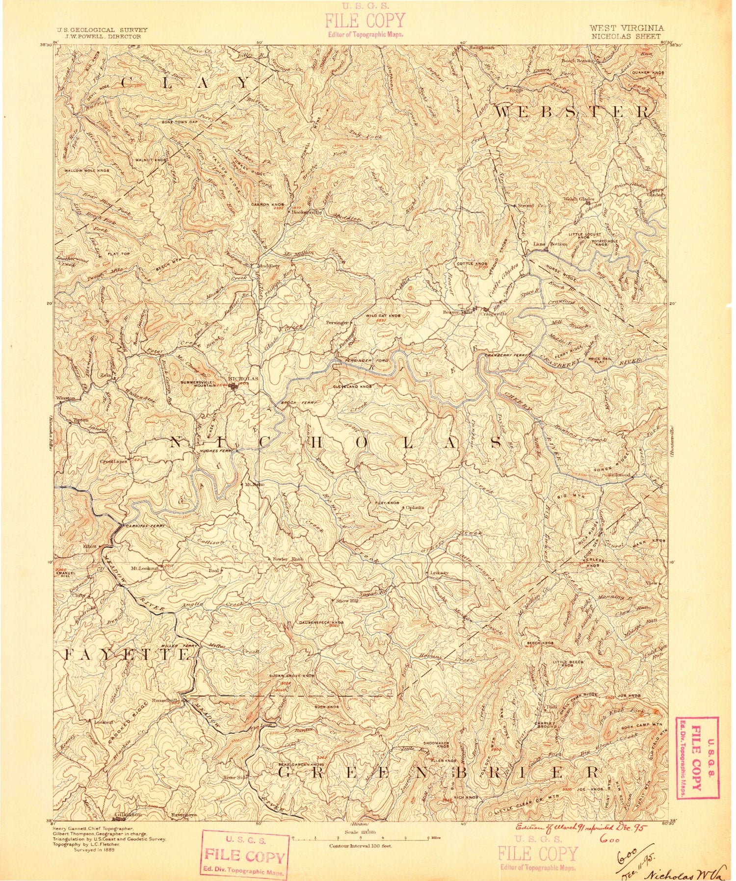
MyTopo
Historic 1889 Nicholas West Virginia 30'x30' Topo Map
Couldn't load pickup availability
Historical USGS topographic map of Nicholas in the state of West Virginia. Scale: 1:125000. Print size: 17" x 24"
This map was published in 1889 and is in the following counties: Clay, Fayette, Greenbrier, Nicholas, Webster.
The map contains contour lines, roads, rivers, towns, streams, and lakes. Printed on high-quality waterproof paper with UV fade-resistant inks.
Contains the following named places: Adkins Branch, Anthony Creek, Arbuckle Branch, Arrowwood Creek, Barnet Run, Barrenshe Branch, Battle Run, Bearhole Ridge, Bearpen Fork, Beech Fork, Big Run, Bills Branch, Birch River, Bonetown Gap, Brackens Creek, Browns Ridge, Brushy Fence Fork, Brushy Fork, Bryant Branch, Bryant Ridge, Bryant Run, Buck Branch, Buck Garden Creek, Cabin Run, Canvas, Carnifex Ferry Battlefield State Park, Carnifex Trail, Carnifex Tunnel, Cat Run, Cherry Run, Clear Fork, Cobb Run, Collison Creek, Corren Knob, Cow Run, Cow Run, Crooked Ridge, Crooked Run, Deal Fork, Dille, Dille Run, Dille Run, Dog Run, Dogwood Creek, Dogwood Ridge, Donahoe Fork, Dorsey Branch, Drennen, Dryhouse Run, Duffy Branch, Duffy Ridge, Elevenmile Fork, Elm Creek, Enoch Branch, Enon, Ewings Branch, Fallrock Branch, Falls Run, Flat Fork, Floyd Creek, Fockler Branch, Fowler Knob, Gilboa, Glade Creek, Glade Creek, Golden Branch, Groves Spring Branch, Gulf Fork, Haynes Branch, Hedricks Creek, Hickory Flat, Hickory Fork, Hickory Fork, Hill Creek, Hog Rock Branch, Hogpen Run, Horse Run, Hurricane Ridge, Hutchison Branch, Ike Fork, Jane Branch, Jerry Fork, Jerry Fork, Jim Young Fork, Jims Creek, Jims Ridge, Jones Branch, Jones Run, Josh Hollow, Kates Creek, Keenan Branch, Keester Ridge, Keslers Cross Lanes, Kettle Run, Laurel Branch, Laurel Creek, Laurel Creek, Laurel Lick Run, Laurel Run, Left Fork Big Beaver Creek, Left Fork Poplar Creek, Libertybowl Branch, Lick Run, Lick Run, Lick Run, Little Creek, Little Dog Run, Little Glade Creek, Little Run, Long Point, Lostlick Run, Lower Cabin Run, Lower Laurel Run, Lower Spruce Run, Lowry Branch, Maston Run, McClung Branch, McKee Creek, Meadow Creek, Meadow Creek, Mill Creek, Miller Creek, Miller Ridge, Ming Run, Mouse Fork, Muddlety, Muddlety Creek, Mudlick Run, Murphy Branch, Neff Fork, North Prong Miller Creek, Norton Branch, Orchid Fork, Paddy Run, Panther Lick Branch, Pearson Branch, Persinger, Pheasant Run, Phillips Run, Pine Ridge, Pine Run, Piney Creek, Poe, Pond Ridge, Poplar Creek, Powell Mountain, Puddy Run, Rader Fork, Rader Run, Ramp Run, Rays Branch, Red Oak Branch, Rich Fork, Rich Fork, Rich Fork, Road Fork, Road Fork, Road Fork, Road Fork, Robinson Fork, Rockcamp Branch, Rockcamp Run, Rockhouse Run, Rucker Bend, Russellville, Salmon Run, Sand Fork, Shant Branch, Shawver Ridge, Shillings Flat, Simmons Branch, Slide Branch, Spanish Oak Branch, Spring Creek, Spring Run, Spruce Run, Spruce Run, Spy Rock, Staton Branch, Stickler Run, Stony Branch, Strickland Run, Sugarcamp Run, Sugarcamp Run, Sugargrove Creek, Sugargrove Knob, Summersville, Summersville Dam, Surbaugh Creek, Sycamore Run, Taylor Creek, The Bend, The Divide, The Divide, The Gulf, The Loop, Thrashhouse Run, Tioga, Tipton, Toms Branch, Toms Creek, Trent Branch, Trout Run, Tucker Fork, Tug Fork, Turkey Creek, Upper Laurel Run, Walker Fork, Wallowhole Fork, Wallowhole Ridge, Walnut Fork, Walnut Knob, Way Back Trail, Whetstone Creek, Whitewater Branch, Widen, Young Monument, Youngs Creek, Zela, Babcock, Cressmont, Donald, Opal, Ravenseye, Nicholas County, Adkins Lick Creek, Adkins Rockhouse Branch, Allen Knob, Allingdale, Amos Run, Anglins Creek, Arcola, Baber Branch, Back Creek, Back Fork, Back Fork