MyTopo
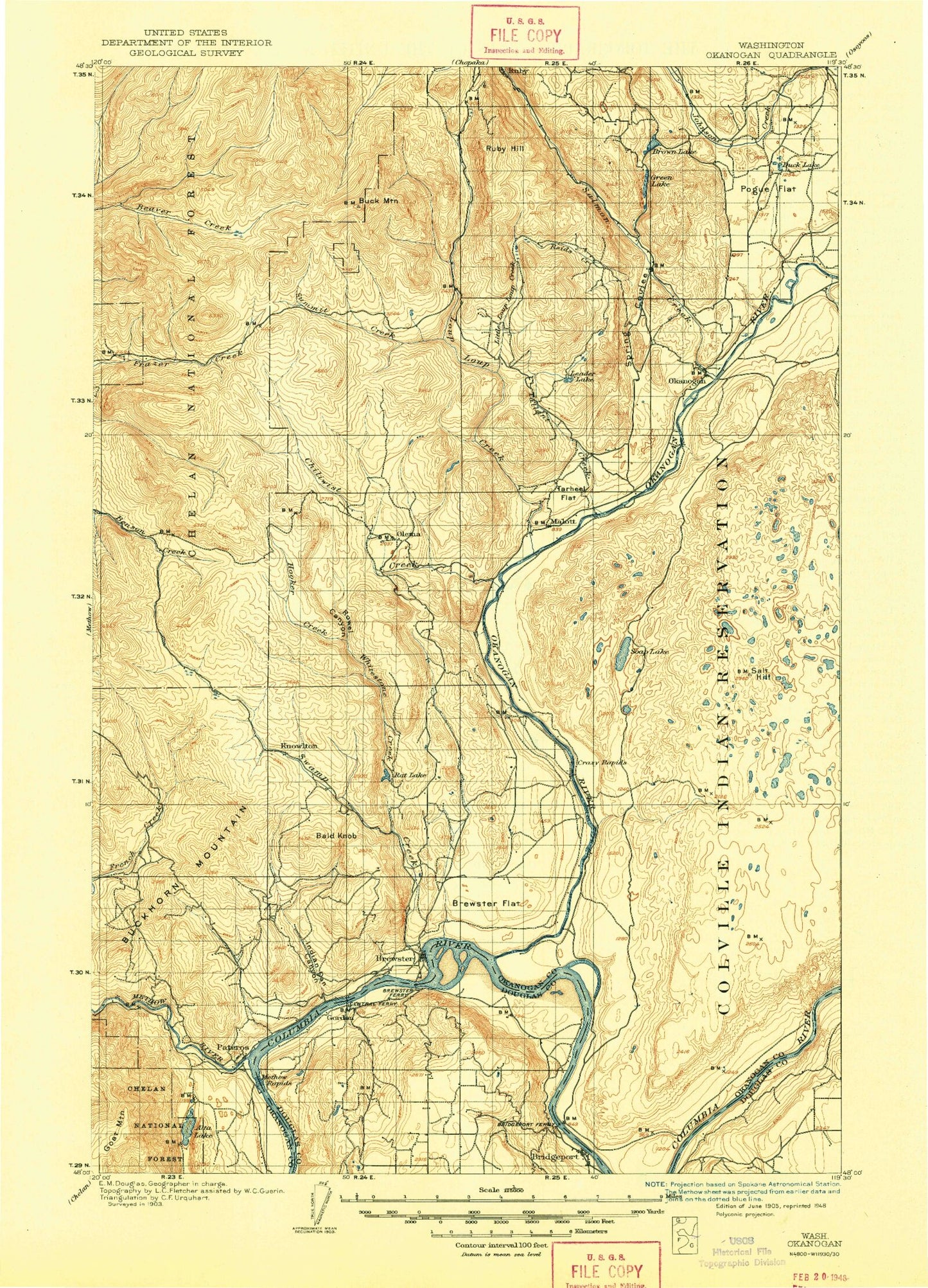
Historic 1905 Okanogan Washington 30'x30' Topo Map
Couldn't load pickup availability
Historical USGS topographic map of Okanogan in the state of Washington. Scale: 1:125000. Print size: 15" x 24"
This map was published in 1905 and is in the following counties: Douglas, Okanogan.
The map contains contour lines, roads, rivers, towns, streams, and lakes. Printed on high-quality waterproof paper with UV fade-resistant inks.
Contains the following named places: Bedar Lake, Bedard School, Bridgeport, Bridgeport Bar, Bridgeport Grange, Bridgeport Point, Bridgeport State Park, Buenna Bar, Cassimer Bar, Chicken Creek, Chief Joseph, Crowfoot Lake, Deep Lake, Farley Lake, Fort Okanogan, Fort Okanogan, Hauan Lake, Island Lake, Jordan Creek, Lawson Lake, McDonald Lake (not official), Morris Lake, Pearl Hill, Reef Rapids, Salt Hill, Snider Flat, Stevens Lake, Lake Thirty-Two, Freshwater Lake, Devils Head, Castle Rock, Rattlesnake Point, Rocky Butte, Old Port Columbia, Washburn Island, Fort Okanogan Overlook, Fort Okanogan State Park, Blacks Lakes, Chief Joseph State Park, Alkali Pond, Timber Peak, White Lakes, Bridgeport Bar State Wildlife Recreation Area, Bridgeport Park, Rock Ridge Park, Waterfront Park, Alexander Lake, Alta Coulee, Alta Lake, Alta Lake State Park, BJ Lake, Bald Knob, Bear Mountain, Beaver Lake Trail, Beaver Mountain, Bobcat Mountain, Brewster, Brewster Flat, Brown Lake, Buck Mountain, Buckhorn Mountain, Buzzard Lake, Cabin Creek, Cameron Lake, Central Creek, Central Ferry Canyon, Chiliwist Butte, Chiliwist Creek, Chiliwist Valley, Chillowist, Coleman Butte, Cook Lake, Cook Mountain, Coyote Ridge, Crazy Rapids, Darling Lake, Davis Canyon, DePue Creek, Dent Mountain, Dougherty Canyon, Dry Creek, Duck Lake, Felix Creek, Finley Mountain, Fox Mountain, Gambles Mill, Goat Mountain, Granite Mountain, Green Lake, Harmony Heights, Hidden Camp, Hooker Creek, Hunsinger Lake, Indian Dan Canyon, J R Picnic Area, Jack Creek, Jackass Butte, Jay Ridge, Kercheval Ranch, Knowlton Knob, Leader Mountain, Leighty Camp, Lightning Creek, Lightning Creek Ridge, Little Buck Mountain, Little Goose Lake, Little Loup Loup Creek, Little Soap Lake, Loup Loup Creek, Loup Loup Recreation Area, Loup Loup Summit, Malott, McDaniel Mountain, Methow River, Middle Fork, Middle Ridge, Monse, Mowich Illahee, Neville Ridge, Okanogan River, Olema, Omak, Omak Creek, Pateros, Lake Pateros, Penley Lake, Pogue Flat, Pogue Mountain, Pole Pick Mountain, Proctor Lake, Rat Lake, Reed Creek, Reed Mountain, Ritchie Ridge, Robinson Canyon, Robinson Flat, Rock Creek, Rock Lakes, Ross Canyon, Rowel Canyon, Rowel Lake, Ruby, Ruby Hill, Salmon Creek, Shellrock Point, Smith Lake, Soap Lake, Soap Lake Mountain, South Fork Benson Creek, South Fork Meadows, South Ridge, Spaulding Lake, Spring Coulee, Starzman Lake, State Road Cabin Camp, Stout Ranch, Sullivan Creek, Summit Creek, Swamp Creek, Sweat Creek, Tallant Creek, Tarheel Flat, Tenas Mountain, Thrapp Mountain, Virginia Lake, Wakefield, Watson Draw, West Fork Rock Creek, Whitestone Creek, Woody Mountain, Woolloomooloo Creek, Yockey Creek, Paradise Hill, Red Shirt Mine, Indian Dan State Wildlife Recreation Area, Rattlesnake Point, Malott, Timerick Mountain, Dry Coulee, Loup Loup Campground, Coyote Canyon, Dan Canyon, Spiegelberg Lake, First Thought Mine, Arlington Ridge, Houghs Mine, Arlington Mine, Fourth of July Mine, Wright Mountain, Reed Pond, Three Buttes, Clements Lake, Fry Lake, Mount Olive, Main Ditch, Low Line Ditch, High Line Ditch, Rimrock Lake, Glover Mountain, Progressive Flat, Reclamation Pond, Last Chance Mine, Central Ferry State Wildlife Recreation Area, Rock Lakes Campground, Pixley Sportsman Park, Rock Creek Campground, Alma Park, Forest Supervisor Headquarters Okanogan National Forest, Leader Lake Campground, Harris Mountain, Rock Lakes Campground, South Summit, Loup Loup Ski Area, Eastside Park, Methow Winter Range and Wildlife Refuge, Gregory Tracts, Inning Field, Chiliwist State Wildlife Recreation Area, Roundup Park, Woody Island, Brown Lake, Ophir, Chiliwist, Okanogan, Downing, Wenner Lakes, Brandts Landing, Bide A Wee Flat, Rat Lake Dam, Little Green Lake Dam, Little Green Lake, Leader Lake Dam, Leader Lake, Wenner Lake Number Two Dam, Wenner Lakes Number Two, Beaver Lake Dam