MyTopo
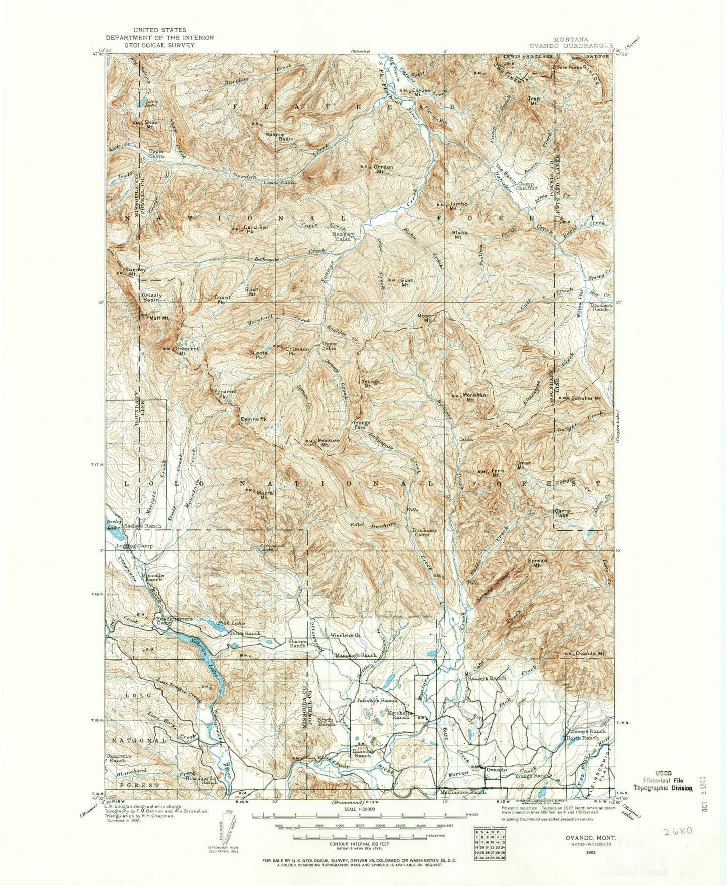
Historic 1902 Ovando Montana 30'x30' Topo Map
Couldn't load pickup availability
Historical USGS topographic map of Ovando in the state of Montana. Scale: 1:125000. Print size: 18" x 24"
This map was published in 1902 and is in the following counties: Lewis and Clark, Missoula, Powell.
The map contains contour lines, roads, rivers, towns, streams, and lakes. Printed on high-quality waterproof paper with UV fade-resistant inks.
Contains the following named places: Double Arrow Ranch, Jacobsen Ditch, Lost Creek, Alloy Mountain, Apex Mountain, Babcock Creek, Bandy Reservoir, Barbour Ditch, Bear Park, Big Knife Lakes, Big Larch Campground, Big Prairie, Big Slide, Bill Creek, Black Canyon Creek, Black Mountain, Blackfoot Divide Trail, Blanchard Flats, Blanchard Lake, Blind Canyon Creek, Boulder Creek, Boyd Mountain, Brownstone Creek, Bullet Nose Mountain, Burnt Cabin, Burnt Cabin Creek, Butcher Creek, Butcher Mountain, Cabin Creek, Camp Creek, Camp Creek Pass Trail, Cardinal Creek, Cardinal Peak, Catchem Creek, Catchem Creek Trail, Cave Creek, Cayuse Mountain, Cedar Falls Ditch, Center Creek, Center Creek Trail, Center Ridge Trail, Chamberlain Creek, Clearwater, Cluster Creek, Cold Brook, Conger Creek Trail, Conger Point, Conger Point Trail, Copenhaver Park, Cott Lake, Cottonwood Creek, Cottonwood Lakes, Count Peak, Crescent Mountain, Crimson Creek, Crimson Lake, Crimson Peak, Day Ditch, Delaware Creek, Devine Creek, Devine Peak, Dick Creek, Doctor Creek, Doctor Lake, Doney Lake, Doney Meadows, Drew Creek, Dry Cottonwood Creek, Dunham Creek, Dunham Creek Ditch, Dunham Lodgepole Trail, Dunham Point, Dunham Trail, Dwight Creek Trail, East Fork McCabe Creek, East Fork Monture Creek, East Fork Spread Creek, East Spread Mountain, Elbow Lake, Elk Creek, Emerson Peak, Evans Lake, Feline Creek, Fenn Mountain, Fenn Mountain Trail, Fish Creek, Big Sky Lake, Fisher Peak, Flatiron Mountain, Florence Lake, Foolhen Creek, Foolhen Creek Trail, Foolhen Mountain, Fossil Mountain, Francois Creek, Furious Creek, Gabe Creek, George Creek, George Lake, Goat Mountain, Gordon Creek, Gordon Mountain, Grace Mountain, Grizzly Basin, Gust Mountain, Hahn Creek, Hahn Creek Pass, Harpers Lake, Hayden Creek, Hoffland Lateral, Holland Gordon Trail, Hoyt Creek, Jacobsen Ranch, James Lake, Jenny Creek, Jones Lake, Jumbo Creek, Jumbo Mountain, Kid Creek, Kid Mountain, Koessler Lake, Krutar Ditch, Lahrity Lake, Lake Otatsy Trail, Lena Lake, Lena Peak, Leota Park, Leota Peak, Lick Creek, Limestone Pass, Limestone Pass Trail, Little Apex Mountain, Little Calf Creek, Little Red Hills, Little Shanley Creek, Lobe Creek, Lodgepole Creek, Lodgepole Trail, Lost Horse Creek, Lost Prairie, Lost Prairie Creek, Lynn Reservoir, Marshall Creek, Marshall Mountain, Martin Park, Matt Mountain, McCabe Creek, McCabe Lake Creek Trail, McCabe Mountain, McCabe Point, Middle Fork Monture Creek, Mollet Park, Monahan Mountain, Monture Creek, Monture Creek Campground, Monture Creek Guard Station, Monture Falls, Monture Haun Trail, Monture Hereford Ranch, Monture Hill, Monture Mountain, Monture Trail, Morrell Creek, Morrell Falls, Morrell Lake, Morrell Lookout, Morrell Mountain, Moser Mountain, Mountain Creek, Mud Lake, Murphy Ditch, Murphy Ranch, Nannie Basin, Nome Creek, Nome Point, North Fork Blanchard Creek, North Fork Cottonwood Creek, Omar Mountain, Upsata Lake, Otis Creek, Otis Lake, Otter Creek, Ovando, Ovando Mountain, Owl Creek, Pearson Creek, Pilot Peak, Pinnacle Peak, Puma Creek, Puma Peak, Pyramid Lake, Pyramid Pass, Pyramid Peak, Railley Mountain, Reef Creek, Rice Lake, Richmond Peak, Ross Creek, Salmon Lake, Scintilla Mountain, Seeley Creek, Shamrock Point, Shanley Creek, Shaw Creek, Shaw Mountain, Shirttail Park, Shoup Creek, Shoup Lake, Smith Creek, Some Creek, Sourdough Island, Spread Creek, Spread Mountain, Spring Creek, Spring Creek, Spruce Creek, Spruce Creek, Sunday Mountain, Swamp Creek, The Basin, Tote Road Lake, Tour Mountain, Trail Creek, Trap Mountain, Trio Mountain, Two Creek Ranch, Una Mountain, Warren Creek, Wedge Creek, West Fork Lake Creek, Woodtick Mountain, Woodworth, Yellowjacket Creek, Youngs Creek, Youngs Mountain, Youngs Pass