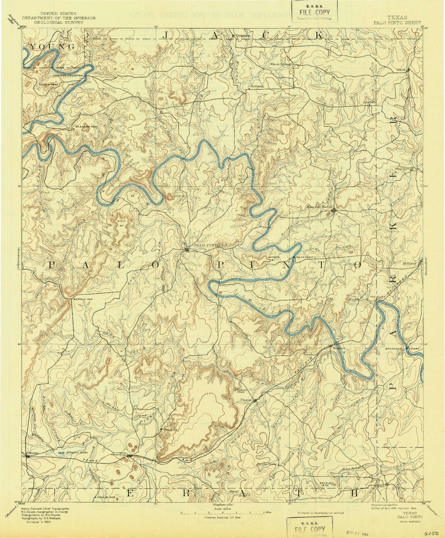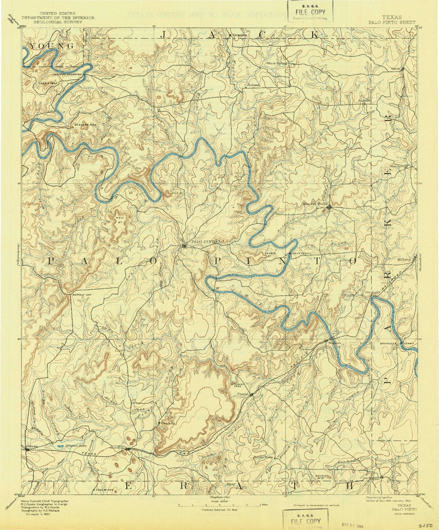
MyTopo
Historic 1891 Palo Pinto Texas 30'x30' Topo Map
Couldn't load pickup availability
Historical USGS topographic map of Palo Pinto in the state of Texas. Scale: 1:125000. Print size: 17" x 24"
This map was published in 1891 and is in the following counties: Eastland, Erath, Hood, Palo Pinto, Parker, Young.
The map contains contour lines, roads, rivers, towns, streams, and lakes. Printed on high-quality waterproof paper with UV fade-resistant inks.
Contains the following named places: Ainsworth Creek, Antelope Mountain, Arteburn Point, B C Harris Bend, Baker Creek, Baker Hollow, Bald Mountain, Ballenger Bend, Barber Mountain, Bath Bend, Bear Canyon, Bear Creek, Bear Creek, Bear Hollow, Belding Oil Field, Belding Ranch, Bennett, Big Sunday Creek, Birdwell Hollow, Bloodweed Island, Blue Flat, Bluff Creek, Boles Rector Oil Field, Brazos, Brewton Canyon, Bridges Branch, Brushy Hollow, Brushy Mountain, Brushy Slough, Buck Creek, Bugle Mountain, Camp Constantin, Camp Dallas, Carter Bend, Carter Branch, Carter Island, Chestnut Bend, Chick Bend, Chimney Slough, Clayton Mountain, Coal Mine Mountain, Costello Island, Crawford Bend, Crawford Hollow, Crawford Mountain, Crockery Creek, Crow Peak, Cyclone Bend, Dairy Mountain, Dalton Bend, Dark Valley Creek, Deep Elm Creek, Devils Hollow, Devils Hollow, Devils Hollow, Dickson-Walker Mountain, Doan Hollow, Dobbs Valley, Dodson Prairie Community Hall, Dog Bend, Double Mountain, Dry Branch, Dry Branch Kickapoo Creek, Dry Creek, Duke Mountain, Duke Mountain Branch, Eagle Creek, East Mountain, Edmondson Bend, Edwards Branch, Elm Creek, Elm Creek, Elm Creek, Filibuster Creek, Flatrock Branch, Flint Bend, Fortune Bend, Fox Mountain, Frank Harris Bend, Frog Branch, Gaines Bend, Garland Bend, Gibson Creek, Gilbert Valley, Gilmore Creek, Gordon, Gordon Mountain, Gordon Oil Field, Graford, Grassy Branch, Grindstone Creek, Grindstone Mountain, Harris Branch, Harris Peak, Hart Bend, Hells Gate, Hittson Bend, Hittson Hollow, Hog Bend, Hogpen Hollow, Honey Creek, Indian Creek, Ioni Creek, Italian Hill, James Lake, Joes Creek, John Hittson Bend, Johnson Bend, Johnson Lake, Johnson Peak, Jones Hollow, Jowell Creek, Judd Switch, Kamp Koinonia, Keechi Creek, Kettle Hollow, Kyle Mountain, Lake Creek, Lipan, Little Keechi Creek, Little Lake, Little Sunday Creek, Littlefield Bend, Live Oak Canyon, Lone Camp, Loving Creek, Loyd-Dalton Oil Field, Massey Branch, McAdams Peak, McAvoy Mountain, McGinnis Point, Meeks Bend, Metcalf Bend, Metcalf Gap, Metcalf Gap, Metcalf Gap Oil Field, Middle Creek, Mill Branch, Mill Branch, Millsap, Mineral Wells, Lake Mineral Wells, Ming Bend, Mingus, Mitchell Mountain, Moffitt Bend, Morris Sheppard Dam, New York Hill, Palo Pinto, Panama Creek, Pecan Branch, Pecan Hollow, Lake Pinto, Polk Stalk Bend, Pollard Bend, Pollard Creek, Pollard Hill, Post Oak Bend, Potato Hill, Rock Creek, Rock Creek, Rock Creek, Rock Crusher Lake, Rocky Bluff Creek, Rocky Creek, Roundtop Mountain, Russel Mountain, Salesville, Saline Creek, Salt Branch, Sand Island, Sand Valley, Santo, Scott Canyon, Steam Shovel Mountain, Skunk Ridge, Snider Branch, Soda Springs Creek, South Fork Palo Pinto Creek, Springer Gap, Storms Mountain, Strawn, Stump Hill, Sugarloaf Mountain, Swank Mountain, Lake Mingus, Tater Hill, Panther Creek, Thunderburg Hollow, Town Branch, Turkey Creek, Turkey Peak, Vaughn Branch, Village Bend, Waco Bend, Walnut Creek, Ward Branch, Ward Mountain, Warters Mountain, Weaver Branch, West Mountain, Whatley Creek, Whit Mountain, Whitley Bend, Whitt, Wilbar Mountain, Wild Bend, Wilson Hollow, Wolf Branch, Wolf Mountain, Wolters Village, Worser Creek, Worth Ranch, Wynn Mountain, Barton Creek, Connor Creek, Cool, Duncan Hollow, East Fork Keechi Creek, Grindstone Creek, Hill Creek, Little Ioni Creek, Lost Creek, Palo Pinto Creek, Patterson Branch, Ramsey Creek, Red Hollow, Rippy Branch, Rock Creek, Schoolhouse Mountain, Turkey Creek, West Fork Keechi Creek, Wilson Creek, Palo Pinto Creek Reservoir, Coalville, Gordon Junction