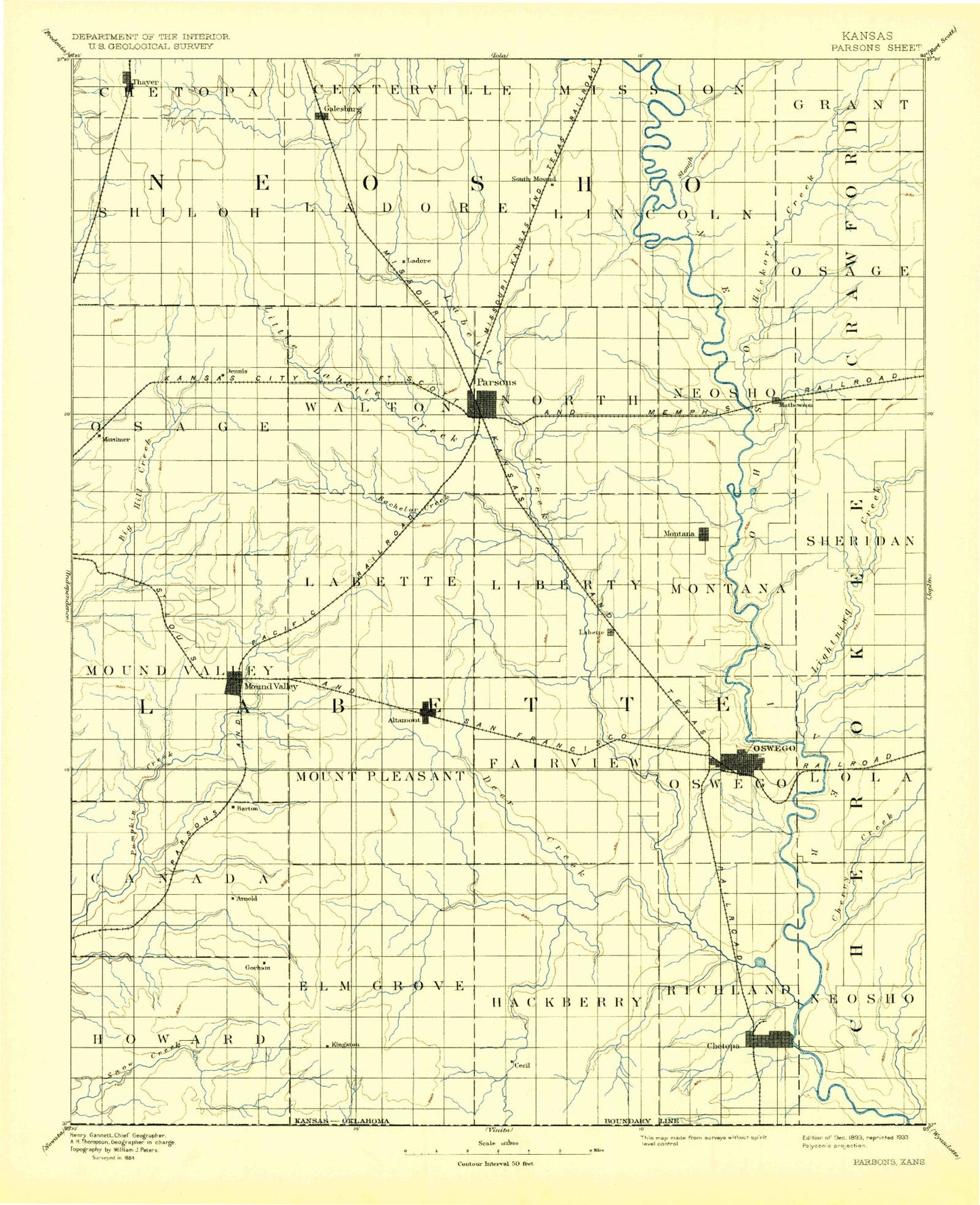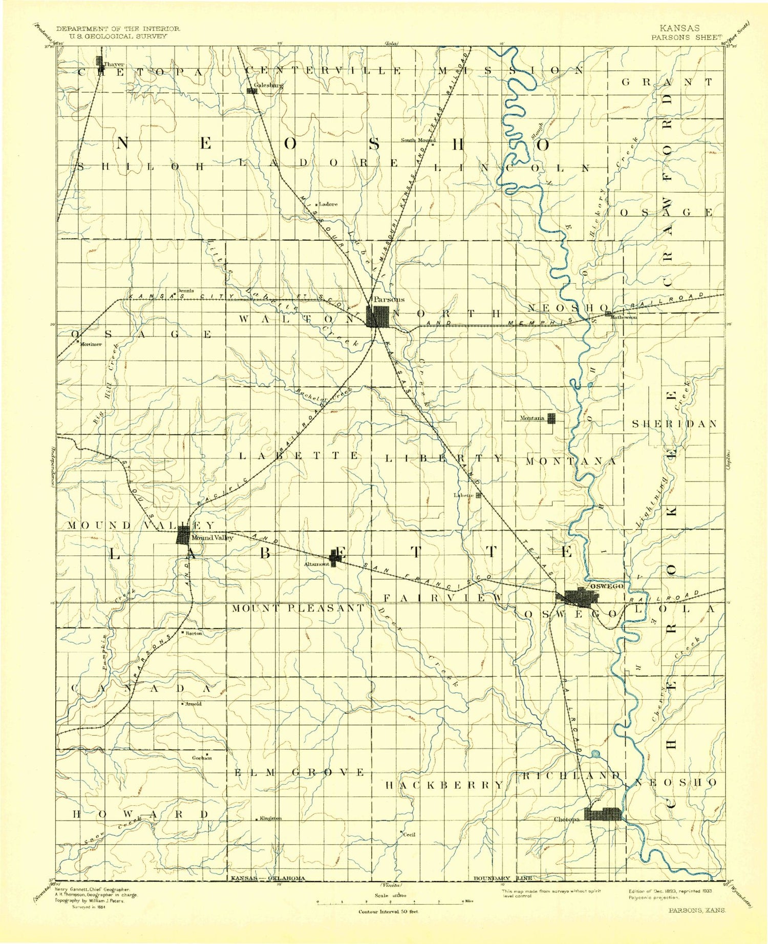
MyTopo
Historic 1893 Parsons Kansas 30'x30' Topo Map
Couldn't load pickup availability
Historical USGS topographic map of Parsonsin the states of Kansas, Oklahoma. Scale: 1:125000. Print size: 17" x 24"
This map was published in 1893 and is in the following counties: Cherokee, Crawford, Labette, Neosho.
The map contains contour lines, roads, rivers, towns, streams, and lakes. Printed on high-quality waterproof paper with UV fade-resistant inks.
Contains the following named places: Angola, Mallard Pond, Valeda, Township of Mount Pleasant, Richland Creek, Rock Creek, Township of Elm Grove, Township of Canada, Township of Howard, Big Hill, Township of Lola, Hubbell Lake, Elmore Park, Short Creek, Marvin Lake, Boone Lake, Chetopa, Big Candy Lake, Little Candy Lake, Cherry Creek, Center Creek, Little Fly Creek, Bartlett, Deer Creek, Township of Oswego, Labette Creek, Town Creek, Township of Richland, Turkey Creek, Lake Creek Oil Field, Edna, Elm Creek, Township of Fairview, Hackberry Creek, Township of Hackberry, Lake Creek, Timber Hill, Mud Creek, Mound Valley, Dixon Mound, Big Hill Wildlife Area, Wildcat Creek, Idle Hour Lake, Altamont, Township of Mound Valley, Township of Labette, Little Bachelor Creek, Labette, Spring Creek, Township of Liberty, Riverside Park, Horseshoe Lake, Mathews Park, Oswego, Township of Montana, Wolf Creek, Deer Creek, Lightning Creek, Township of Sheridan, Township of Neosho, Service Lake, McCune, Litup Creek, Township of Osage, Hickory Creek, Stink Branch, Township of Shiloh, Thayer, Galesburg, Tolen Creek, Lake Parsons, Township of Ladore, Neosho River Cutoff, South Mound, Parsons Dam, Murphy Creek, Township of Lincoln, Little Halfmoon Lake, Halfmoon Lake, Township of Neosho, Marvel Park, Montana, Orchard Park, Lopez Park, Forest Park, Parsons, Circle Park, Glenwood Park, Winway Park, Tackett Mound, Township of North, Bachelor Creek, Little Labette Creek, Township of Walton, Twin Mounds, Bender Mounds, Big Hill Dam, Big Hill Lake, Township of Osage, Lake McKinley, Neosho Wildlife Area, Brogan Creek, Neosho State Fishing Lake, Neosho County State Park Dam, Altamont Dam, Bartlett Dam, Edna City Dam, Lake Parsons Dam, Thayer City Dam, City Lake, Labette County Fairgrounds, Harmon Wildlife Area, Belmont Square, Hines Lake, Lost Branch, Big Hill Siding, Winway, Faulkner, Penfield, Stover, Garvin, Hoag, Strauss, Sherman, Hayden, Brownstone, Laneville, Grove, Fern, Dennis, Labette County, Kansas State University Southeast Agricultural Research Center Mound Valley Field Office, Parsons Golf Club, City of Chetopa, City of Oswego, City of Parsons, City of Altamont, City of Bartlett, City of Edna, City of Galesburg, City of McCune, City of Mound Valley, City of Labette, City of Thayer, Kansas State University Southeast Agricultural Research Center - Parsons Unit, Bartlett Wastewater Treatment Plant, Altamont Sewer Treatment Plant, Thayer Sewer Treatment Plant, Galesburg Wastewater Treatment Plant, Chetopa Wastewater Treatment Plant, Edna Wastewater Treatment Plant, Parsons Wastewater Treatment Facility, Oswego Wastewater Plant, Mound Valley Wastewater Plant, McCune Sewer Treatment Plant, Flynn Industrial Park, Parsons Arboretum, Parsons Water Treatment Plant, Hillside Mobile Home Park, Lawndale Estates Mobile Home Park, Katy Parsons Golf Club, Oswego Golf Course, Beachner Grain Elevator Number 1, Beachner Grain Elevator Number 15, McCune Farmers Union Co - Operative Association Grain Elevator Number 1, Bartlett Co - Operative Association Grain Elevator Number 1, Bartlett Co - Operative Association Grain Elevator Number 2, Bartlett Co - Operative Association Grain Elevator Number 3, Bartlett Co - Operative Association Grain Elevator Number 4, Bartlett Co - Operative Association Grain Elevator Number 5, Faulkner Grain Elevator Number 1, Labette County Quarry, Pontious Family Farm, Lake Creek