
MyTopo
Historic 1891 Parsons West Virginia 30'x30' Topo Map
Couldn't load pickup availability
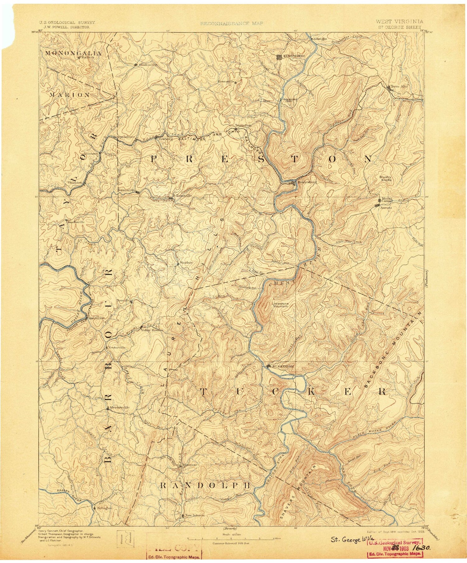
Historical USGS topographic map of Parsons in the state of West Virginia. Scale: 1:125000. Print size: 17" x 24"
This map was published in 1891 and is in the following counties: Barbour, Marion, Monongalia, Preston, Randolph, Taylor, Tucker.
The map contains contour lines, roads, rivers, towns, streams, and lakes. Printed on high-quality waterproof paper with UV fade-resistant inks.
Contains the following named places: Backbone Mountain, Amblersburg, Arden, Ashpole Run, Baker Run, Bear Run, Belington, Big Run, Big Run, Bills Creek, Birds Creek, Bonica Run, Boyd Run, Brains Creek, Brocum Run, Browns Chapel, Browns Mill, Bucklick Run, Buffalo Run, Calhoun, Camp Barbour, Cherry Run, Church Creek, Concord, Cooks Run, Cove Run, Cunningham Run, Daugherty Run, Dogtown, Dority Run, Dunkard Bottom, Elsey Run, Evansville, Fairfax Pond, Fellowsville, Fields Creek, Flat Run, Freeport, Frog Run, Frost Run, Glade Run, Glade Run, Glade Run, Glady Creek, Heather Run, Howesville, Hunter Fork, Independence, Irish Ridge, Irish Run, Jeffry Fork, Joes Run, Joes Run, Kingwood, Kinsinger Run, Knottsville, Koontz Hollow, Laurel Creek, Laurel Run, Laurel Run, Left Fork Sandy Creek, Lick Run, Lick Run, Lick Run, Little Bucklick Run, Little Cove Run, Little Laurel Run, Little Raccoon Creek, Little Sandy Creek, Long Run, Manown, Maple Run, Maple Run, Martins Run, Meadowville, Mill Creek, Mill Creek Reservoir, Millertown, Mitchell Run, Moatsville, Moats Hollow, Morgan Run, Mountain Run, Mouse Run, Mud Run, Negro Hollow, North Branch Snowy Creek, Oldroad Run, Mount Phoebe, Pine Run, Pringle Run, Raccoon Creek, Ragtavern Run, Right Fork Little Sandy Creek, Rocky Branch, Sand Ridge, Sand Run, Shooks Run, Siggens Hollow, South Fork Greens Run, Spruce Run, Squires Creek, Stacks Run, Stamping Ground Run, Stony Run, Stony Run, Stringtown, Sugar Creek, Swamp Run, Tacy, Terra Alta, Terra Alta Lake, Thornton, Tibbs Run, Toms Run, Tunnelton, Valley Bend, Victoria, Wardwell Run, White Oak Springs, Whitman Run, Wolf Run, Wolf Run, Wolf Run, York Run, Claude, Eby, Hiram, Hopemont, Kalamazoo, Kanetown, Marquess, Scotch Hill, Sinclair, Aarons Run, Baldlick Fork, Bear Run, Bear Run, Bear Run, Bear Run, Bearpen Hollow, Bearwallow Ridge, Bearwallow Run, Bearwallow Run, Bell Hollow, Bennet Rock Trail, Big Cove Run, Big Run, Big Run, Big Run, Big Spring Run, Big Springs Gap, Bingham Run, Birchroot Run, Black Fork, Black Lick Run, Blackwater River, Bonifield Run, Boundary Trail, Brannons Run, Bridge Run, Briery Mountains, Brights Run, Brookside, Brushy Fork, Buckhorn Run, Bucklick Run, Buffalo Creek, Bull Run, Cabbage Run, Camp Hollow, Camp Kidd, Campfield Run, Canoe Run, Canyon Rim Trail, Cathedral State Park, Cave Run, Cherry Fork, Cherry Run, Choke Trap Run, Clay Lick Run, Close Mountain, Clover Run, Coal Run, Colebank, Coon Hollow, Davis Lick, Devils Dump Run, Dog Run, Drift Run, Dry Fork, Dry Run, Dry Run, East Fork Cherry Fork, Eglon, Elk, Elklick Run, Elklick Run, Erwin, Fill Hollow, Finley Run, Fishing Trough Hollow, Flag Run, Flat Rock Run, Flat Rock Trail, Flatbrush Run, Fools Run, Ford Run, Fork Mountain, Forty Three, Friends Gap, Frog Run, Glade Run, Gladwin, Glady Fork, Goodwin Run, Grasslick Run, Green Mountain, Green Mountain Trail, Green Valley, Haddix Run, Hambleton, Hawk Run, Hickman Slide Hollow, Hickory Bearpen Run, Hickory Lick Run, High Ridge, Hile Run, Hogback, Holly Meadows, Horse Shoe Run, Horseshoe Bend, Horseshoe Run, Horseshoe YMCA Camp, Hovatter, Hunting Camp Run


