MyTopo
Historic 1908 Patapsco Maryland 30'x30' Topo Map
Couldn't load pickup availability
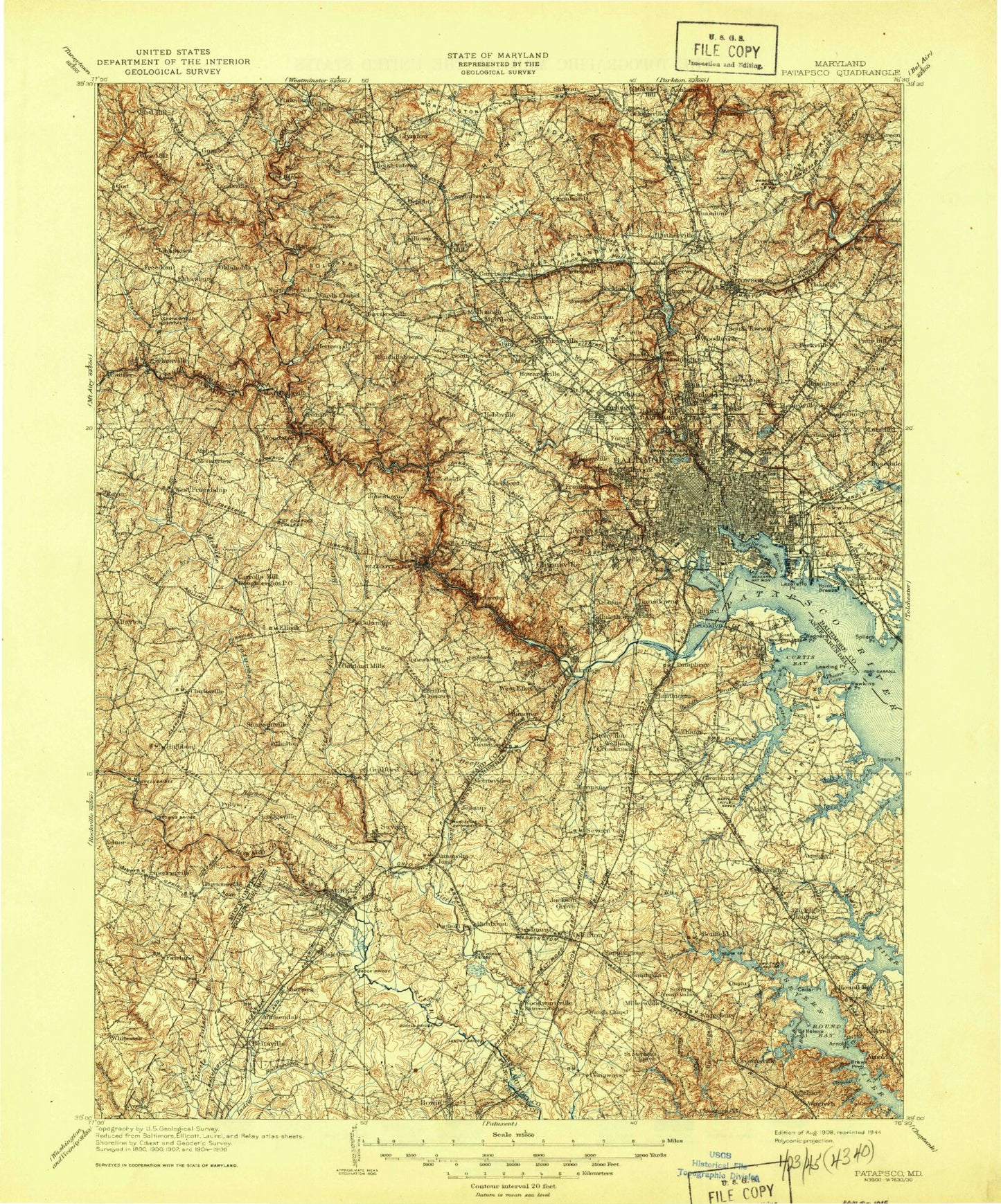
Historical USGS topographic map of Patapsco in the state of Maryland. Scale: 1:125000. Print size: 17" x 24"
This map was published in 1908 and is in the following counties: Anne Arundel, Baltimore, Baltimore (city), Carroll, Howard, Montgomery, Prince George's.
The map contains contour lines, roads, rivers, towns, streams, and lakes. Printed on high-quality waterproof paper with UV fade-resistant inks.
Contains the following named places: Towson Run, Arnold, Arnold Point, Arundel Cove, Arundel Village, Asquith Creek, Back Cove, Back Creek, Bacon Ridge, Baisman Run, Baltimore Highlands, Bear Creek, Beaverdam Pond, Beaverdam Run, Beechwood Park, Beehive Beach, Beehive Cove, Bens Run, Benson Branch, Big Burley Cove, Breezy Point, Brewer Point, Brewer Pond, Brice Run, Burtonsville, Cabin Branch, Camp Barrett, Camp Milldale, Camp Woodland, Catonsville, Cattail Creek, Cedar Branch, Cedar Point, Chase Creek, Chimney Branch, Clement Cove, Clements Creek, Cloverly, Cochrans Pond, Cockey Creek, Coffin Point, Goose Neck, Cooks Branch, Cooper Branch, Councilmans Run, Cowen Run, Cox Creek, Cypress Creek, Daniels, Davis Branch, Davis Tunnel, Deep Ditch Branch, Deep Run, Deep Run, Dipping Pond Run, Dividing Creek, Dogwood Run, Dorsey Run, Dulaney Branch, Eaglenest Point, East Branch Herbert Run, Eli Cove, Elioak, Ellicott City, Falls Run, Finksburg, Fitzhugh Run, Focal Point, Forked Creek, Franklin Branch, Fulton, Furnace Creek, Gamber, Good Hope, Granite Branch, Green Spring Valley, Gumbottom Branch, Gwynn Oak Park, Gwynnbrook State Game Farm, Hammond Branch, Hampton National Historic Site, Hanover, Herbert Run, Hollofield Tower, Holly Creek, Hopkins Creek, Horsehead Branch, Howardsville, Jabez Branch, Jenkins Run, Jones, Kenwood, Keysers Run, Kyle Point, Lake Roland Park, Liberty Dam, Liberty Lake, Little Morgan Run, Little Round Bay, Loch Raven Dam, Loch Raven Reservoir, Locust Run, Long Branch Park, Long Cove, Long Point, Long Quarter Branch, Louisville, Lovel Point, Luce Creek, Magothy Park Beach, Marble Hill, Mardella Branch, Marley Creek, Marley Neck, Mathiers Point, Merryman Branch, Middle Patuxent River, Midway Branch, Mill Creek, Miller Run, Minebank Run, Montevideo, Moores Branch, Morgan Run, Nabbs Creek, Norris Run, North Branch Jones Falls, North Ferry Point, Oakview, Old Man Creek, Oregon Branch, Oregon Pool, Overshot Run, Owings Mills, Patapsco State Park, Patuxent, Peachorchard Cove, Peoples Gospel Park, Perrywood Estates, Pikesville, Pikesville Reservoir, Piney Branch, Piney Run, Piny Run, Plum Creek, Plumtree Branch, Prugh Branch, Red Hill Branch, Red Run, Ringgold Cove, Robinson, Rock Creek, Rockburn Branch, Roland Run, Lake Roland, Round Bay, Royston Branch, Rush Brook, Saint Georges, Saint Helena Island, Saltworks Creek, Sawmill Creek, Scotts Level Branch, Severn Forest, Severn Run, Slade Run, Slaughterhouse Branch, Sloop Cove, Soapstone Branch, Soldiers Delight, Sollers Point, Solleys Cove, South Branch Patapsco River, South Ferry Point, Spring Branch, Stahl Point, Steedmans Point, Stony Creek, Stony Point, Stony Run, Sucker Branch, Sullivan Cove, Swan Creek, Swan Point, Sylvan Dell Valley, Tanyard Cove, Tar Cove, Terrapin Branch, Texas, The Caves, Thomas Branch, Thomas Point, Thornwood Park, Timber Run, Towsers Branch, Union Dam, University of Maryland Plant Research Farm, Valentine Creek, Valley Stream Estates, Villa Nova, Walter Reed Medical Center Farm, Water Oak Point, Lake Waterford, Weems Creek, West Branch Herbert Run, Western Run, Whites Cove, Worthington Valley, Yantz Creek, Rock Cove, The Narrows, Joy Harbor, Brewer Creek, Maynadier Creek, Cool Spring Cove, Sollers Point, Fort George G Mead Junction, Belvoir Manor, Browns Corner, Henryton, Iglehart, Ilchester, Severn Crossroads, Slacks Corner, Fort McHenry Anchorage, Masonville, Fishing Point Shoal, Sollers Point Shoal, Marine Channel, Hawkins Point Shoal, Brewerton Angle, West Channel, East Channel, Fort McHenry Angle, Seagirt Marine Terminal, Coal Pier Channel