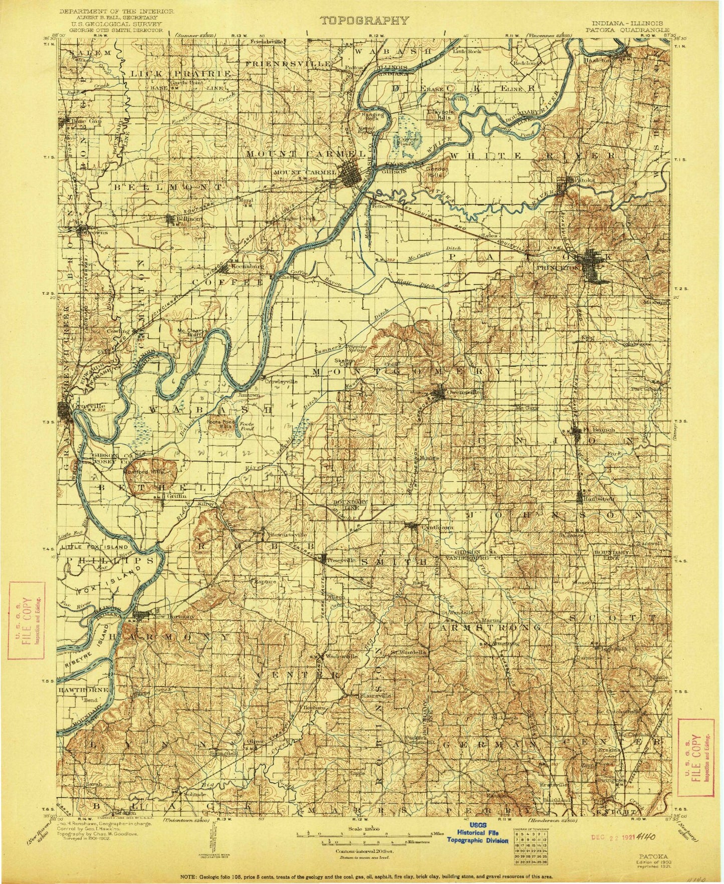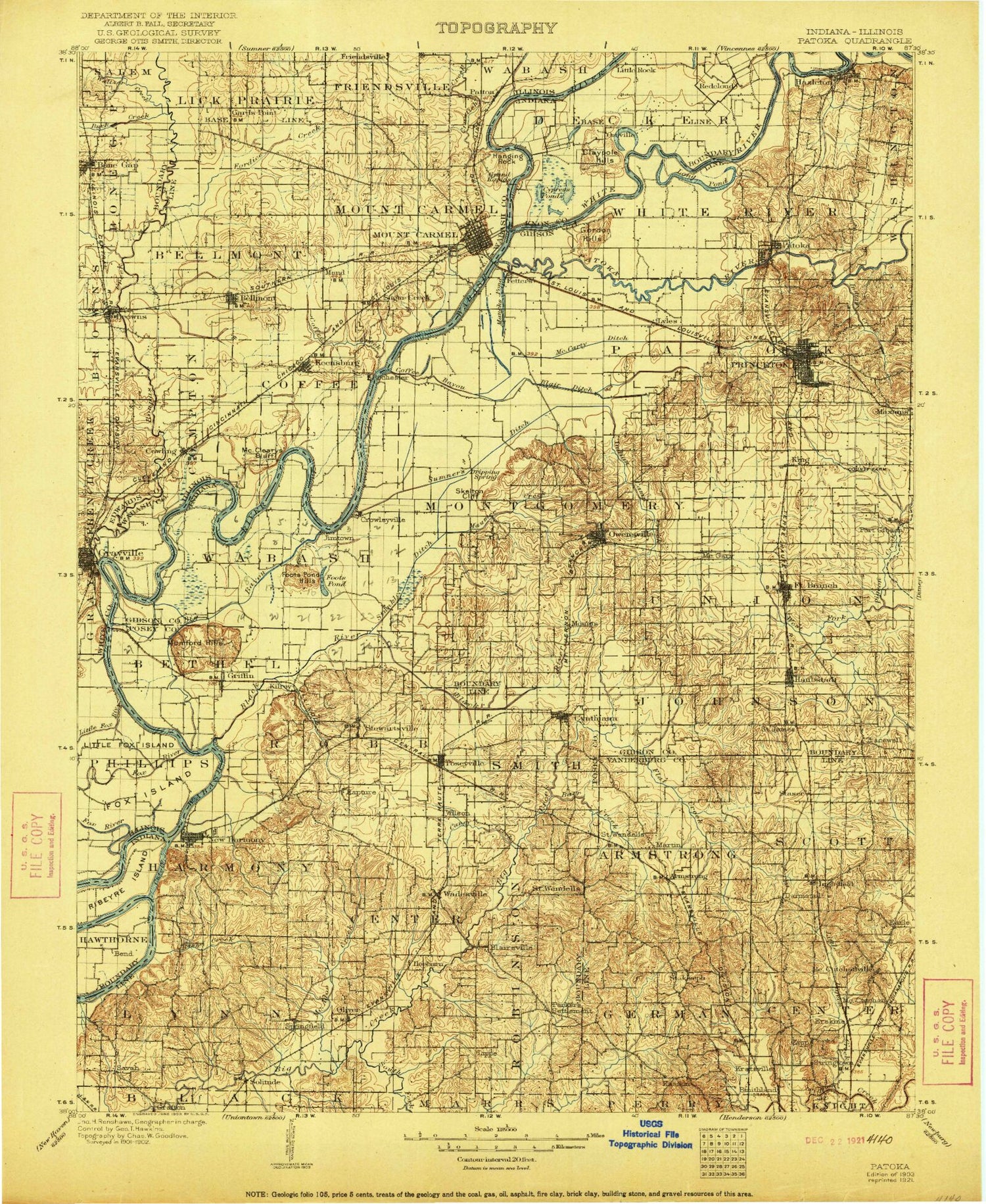
MyTopo
Historic 1903 Patoka Indiana 30'x30' Topo Map
Couldn't load pickup availability
Historical USGS topographic map of Patoka in the state of Indiana. Scale: 1:125000. Print size: 17" x 24"
This map was published in 1903 and is in the following counties: Edwards, Gibson, Knox, Posey, Vanderburgh, Wabash, White.
The map contains contour lines, roads, rivers, towns, streams, and lakes. Printed on high-quality waterproof paper with UV fade-resistant inks.
Contains the following named places: Fox River, Lost Lake, Old Channel, Alexander Creek, Andrews Run, Armstrong, Bald Hill, Barr Creek, Barren Creek, Barren Creek, Barrett, Beech Grove Run, Belcher Ditch, Bend Run, Big Bayou, Black River, Blair Ditch, Blairsville, Blood Ditch, Book Run, Broad Pond, Brown Ditch, Buente Creek, Burnet Pond, Camp Carson, Camp Pahoka, Camp Reveal, Caney Creek, Clark Run, Claypole Pond, Coffee Bayou, Coffee Bayou, Coffee Island, Continental Camp, Coon Creek, Cord Run, Country Club Meadows, Crawleyville, Cynthiana, Cypress Swamps, Darmstadt, David Run, Douglas, Duo Run, Durham, Earle, East Mount Carmel, Emerson Ditch, Foote Pond, Foote Pond Hills, Fort Branch, Franks Ditch, French Run, Fun Creek, Gin Run, Goad Brook, Goose Pond, Gordon Hills, Grafton, Grand Rapids, Griffin, Ha Brook Creek, Hand Branch, Harmony Creek, Harwood, Haubstadt, Hawthorne Creek, Hazleton, Hepburn, Hickory Ridge, Hickory Ridge Lateral, Higginbotham Ditch, Highland, Hillsdale, Hull Ditch, Hurricane Creek Ditch, Indian Creek, Inglefield, Jimtown, Johnson, Johnson Ditch, Johnson Drain, Jordan Creek, Kasson, Kellys Ripple, Keniepe Lateral, King, Kingdom Island, Knob Hill, Knowles Lake, LaRoche Lake, Lafayette Park, Lakewood Hills, Large Drain, Lick Creek, Lillard Ditch, Lilly Run, Lippe, Little Creek, Little Pigeon Creek, Little Rock, Little Sumner Ditch, Loefler Ditch, Long Pond, Long Run, Lyles, Maidlow Ditch, Maple Run, Martin, Mauck Run, Maucks Pond, McAdoo Creek, McCarty Ditch, McCutchanville, McGary Ditch, McGray Ditch, Melody Hill, Melody Run, Montgomery Ditch, Mounts, Mumford Hills, Murphy Park, Murphy Run, Nash Park, Nest Run, New Harmony, Newman Lateral, Nisbet, Oka Run, Old Beech Creek, Old Brook, Old Channel Wabash River, Olive Creek, Oliver, Oliver Run, Orrville, Orrville Hills, Owen Run, Owensville, Pahoka Creek, Paper Run, Parkers Settlement, Patoka, Patoka Island, Peankishaw Bend, Pearl Island, Pond Flat Ditch, Poseyville, Rapture, Ribeyre Island, Richland Creek, Road Brook, Robb Creek, Rush Creek, Saint James, Saint Joseph, Saint Wendel, Sand Creek, Sand Hill, Sandy Creek, Saunders Ditch, Savah, Scott Ditch, Scott Lateral, Seed Run, Skelton, Skelton Branch, Skelton Creek, Smith Run, Solitude, Solitude Run, South Side Park, Springfield, Stacer, Stewartsville, Stormont Ditch, Stringtown, Swift Run, The Labyrinth State Memorial, Thompson Ditch, Thompson Ditch, Thompson Ditch, Thorn Run, Thrall Run, Toops Ditch, Tri Brook, Trippet Ditch, Uno Run, Wabash River Old Channel, Wadesville, Wallenmeyer Ditch, War Branch, Warrenton, Watson Lateral, Watts Ditch, West Fork Pigeon Creek, White River, White River, Wilson Brook, Luke Decker Claim, Decker Chapel, Oliver Underground Gas Storage Area, Kahr Lake, Kahre Lake Dam, Harmonie State Park, New Harmony State Memorial, Gibson Public Service Generation Plant Dam, Harold Mann Lake Dam, Harold Mann Lake, Mater Dei Provincial Lake Dam, Mater Dei Provincial Lake, Schnake Lake, Schnake Lake Dam, Edgewater Lake Dam, Edgewater Lake, Pahoka Camp Lake Dam, Pahoka Camp Lake, Cox Creek, Hurricane Creek, Lake Gibson Conservation Dam, Lake Gibson, North Lake Estates Lake Dam, North Estates Lake, Ray Nell Acres Lake, Ray Nell Acres Lake Dam, Bittner Lake, Bittner Lake Dam, Morgan Lake Dam, Morgan Lake, New Baltimore, Kratzville, Erskine Station, North Park Shopping Center, Mechanicsville, Raben Branch, Gibson County