MyTopo
Historic 1906 Patuxent Maryland 30'x30' Topo Map
Couldn't load pickup availability
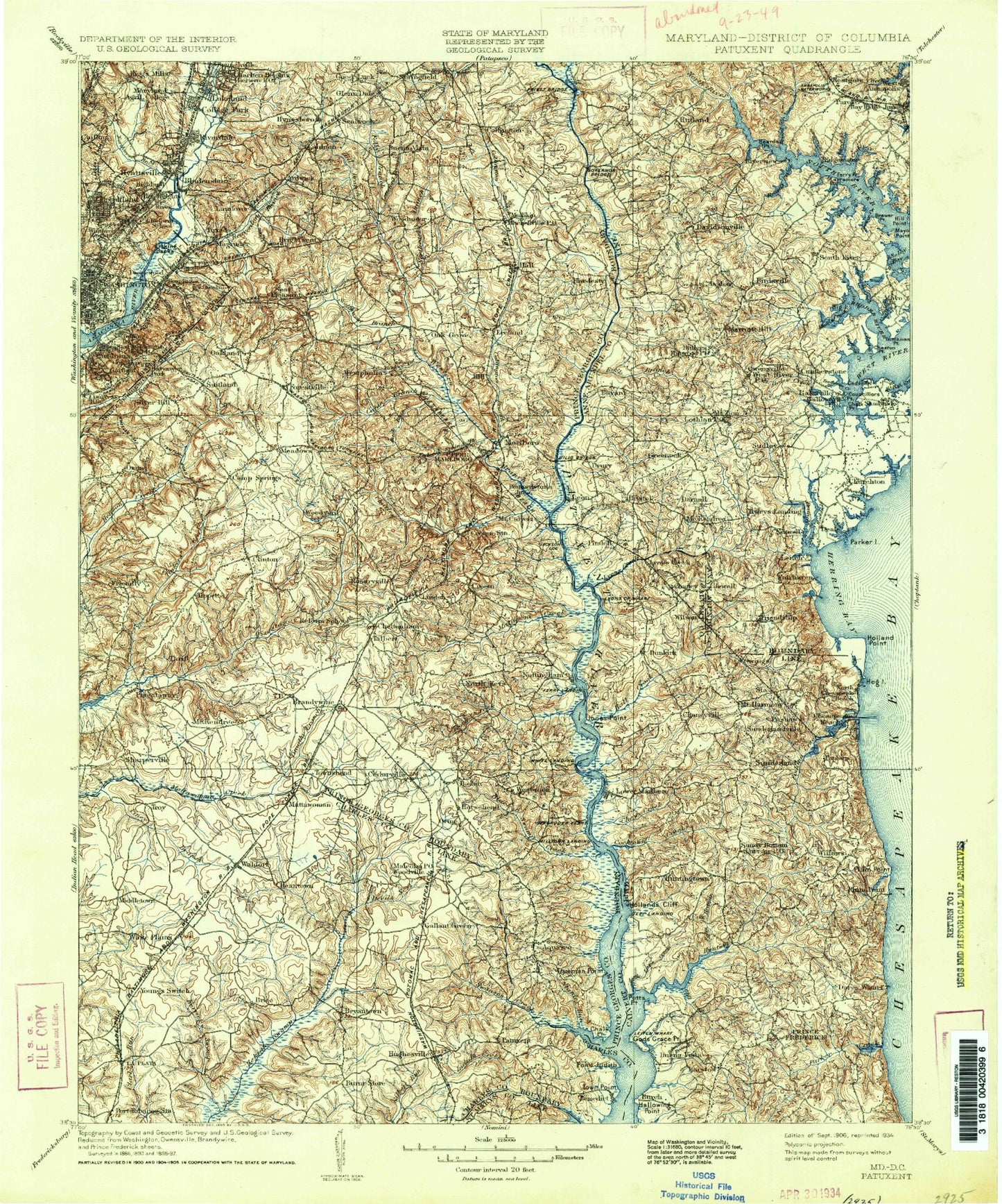
Historical USGS topographic map of Patuxent in the state of Maryland. Scale: 1:125000. Print size: 17" x 24"
This map was published in 1906 and is in the following counties: Anne Arundel, Calvert, Charles, District of Columbia, Montgomery, Prince George's, St. Mary's.
The map contains contour lines, roads, rivers, towns, streams, and lakes. Printed on high-quality waterproof paper with UV fade-resistant inks.
Contains the following named places: Barnard Hill Park, Anacostia Park Section G, Oxon Run Parkway, Beaverdam Creek, Piney Run, Watts Branch, Aberdeen Creek, Addison Point, Almshouse Creek, Arundel Ridge, Back Creek, Bacon Ridge Branch, Bare Neck Shore, Battees Point, Bear Neck Creek, Beards Creek, Beards Point, Beech Hollow, Bell Branch, Benedict, Beverly Beach, Beverly Lake, Big Hob Run, Turkey Point Island, Big Woods Branch, Birdsville, Bluejay Branch, Boathouse Creek, Boyd Point, Brewer Creek, Brewer Point, Broad Creek, Broadwater Creek, Burnt Store, Cabin Branch, Cadle Creek, Camp Letts, Camp Roosevelt, Camp Wabanna, Caney Creek, Carr Wharf, Carrs Creek, Cat Pond, Cedar Point, Cedar Point, Cedar Point, Chalk Point, Chaneyville, Cheston Creek, Cheston Point, Chew Creek, Childs Point, Church Creek, Churchton Recreation Area, Cocktown Creek, Contees Wharf, Councillors Point, Cox Creek, Crab Creek, Cypress Bog, Davidsonville Branch, Davis Point, Davidsonville, Deadwood Cove, Deep Cove Creek, Deep Creek, Deep Creek, Deep Pond, Deep Run Branch, Devils Nest, Drum Point, Dunkirk, Dutchman Point, Elbow Lake, Fairhaven Cliffs, Ferry Branch, Ferry Point, Fishing Creek, Flag Pond, Flag Pond Creek, Flat Creek, Flat Island, Forest Point, Fossil Ravine, Fowlers Mill Branch, Fox Creek, Friday Creek, Gallant Green, Galloway Creek, Gingerville Creek, Glebe Bay, Glebe Branch, Glebe Creek, Glen Isle, Gods Grace Point, Goose Island, Graham Creek, Granville Creek, Hall Creek, Hallowing Point, Hardestys Cove, Harness Creek, Harwood Hollow, Herring Bay, Herring Bay View, Hidden Pond, Hidden Spring Trail, High Island, Highview-on-the-Bay, Holland Cliff, Holland Point, House Creek, Hundley Pond, Hunting Creek, Johns Creek, Jones Point, Jordan Swamp, Jug Bay, Kerrick Swamp, Kings Branch, Kings Branch, La Plata, Larkington Cove, Larrimore Point, Left Trail, Leitch Wharf, Lerch Creek, Limehouse Cove, Little Island, Little Lyons Creek, Little Patuxent River, Locust Grove Beach, Locust Point, Long Bar, Long Point, Lower Marlboro, Lyons Creek, Lyons Creek Fischers, Lyons Creek Wharf, Many Fork Branch, Mayo Point, McKinley Point, Melvin Point, Mill Creek, Mill Creek, Mill Dam Run, Mill Swamp Branch, Mount Harmony, Muddy Creek, Murray Wharf, Neiman Point, Newtown, North Basin, North Fork Muddy Creek, North River, Old Colony Cove, Owings Cliffs, Pages Swamp, Panhandle Trail, Parish Creek, Parker Creek, Parkers Creek, Persimmon Point, Pig Pond, Pindell Branch, Piney Branch, Piney Branch, Plum Point Creek, Pocahontas Creek, Pooles Gut, Popham Creek, Porter Point, Potts Point, Ramsey Creek, Reed Marsh, Reits Branch, Rhode River, Rock Branch, Rockhold Creek, Ropers Branch, Salt Pond, Sand Point, Scaffold Creek, Schoolhouse Branch, Selby Bay, Sellman Creek, Sewell Branch, Shadow Point, Shadyside Recreation Area, Sheephead Cove, Smoots Pond Run, South Basin, South Creek, South Fork Muddy Creek, South Point, South River Park, South Trail, Southern Maryland Public Works Camp, Spyglass Island, Steiners Wharf, Stocketts Run, Sullivan Branch, Sunset Trail, Tabernacle, Tarnans Branch, Teague Point, Tenthouse Creek, The Mess, Town Point, Tracys Creek, Trotts Branch, Two Run Branch, Waldorf, Warners Point, Wayson Pond, West River, West River, West Trail, Whitemarsh Creek, Whitestake Point, Wild Rose Shores, Wilson Owens Branch, Wolf Den Trail, Zekiah Swamp, O'Neill Island, Lothian, Covenant Creek, Camp Run, Red House Branch, Forbidden Run, Church Run, Cutover Swamp, Cub Neck Creek, Deer Branch, Frog Haven, Fresh Pond