MyTopo
Historic 1935 Pendleton Oregon 30'x30' Topo Map
Couldn't load pickup availability
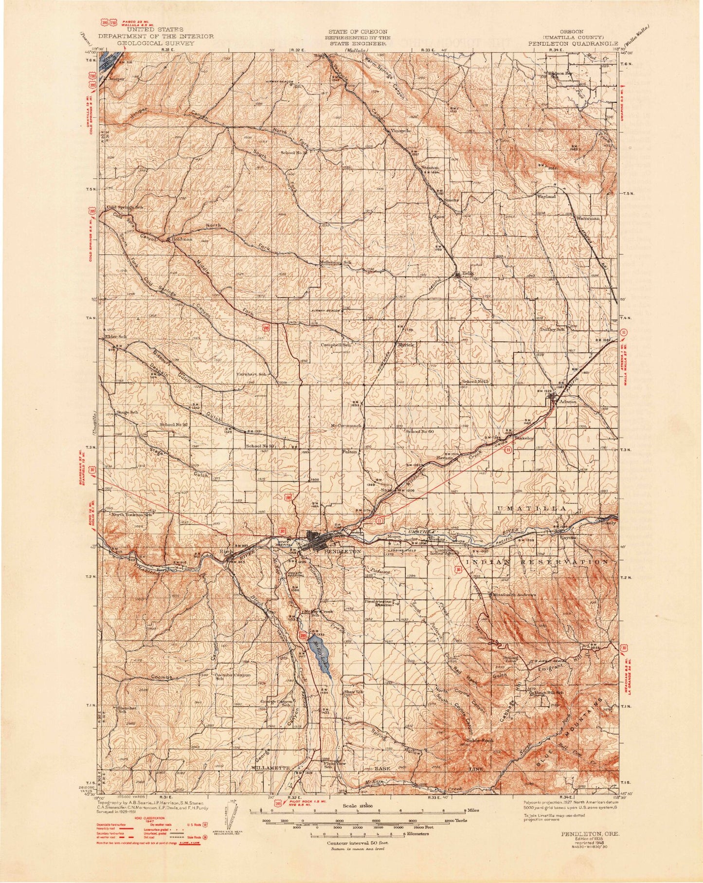
Historical USGS topographic map of Pendletonin the states of Oregon, Washington. Scale: 1:125000. Print size: 17" x 24"
This map was published in 1935 and is in the following counties: Benton, Umatilla, Walla Walla.
The map contains contour lines, roads, rivers, towns, streams, and lakes. Printed on high-quality waterproof paper with UV fade-resistant inks.
Contains the following named places: Adams, Aldrich Park, Birch Creek, Cabbage Hill, Calamity Creek, Coombs Canyon, Coonskin Creek, Cottonwood Creek, Crawford Hollow, Cross Ranch, Deadman Pass, Deadman Pass Canyon, Doe Canyon, Dugger Creek, Emigrant Hill, Fallen Field, George Canyon, Gerking Creek, Gerking Flat, Greasewood Creek, Helix, Holdman, Indian Ceremonial Ground, Kanine Ridge, Kings Corner, Little Greasewood Creek, Little McKay Creek, Lost Pin Creek, McCall Canyon, McCormmach Creek, McDonald Canyon, McKay Creek National Wildlife Refuge, Middle Fork Cold Springs Canyon, Mission, Mission Creek, Missouri Gulch, Moonshine Creek, Nelson Creek, North Coyote Canyon, North Coyote Creek, North Fork Cold Springs Canyon, North Fork Juniper Canyon, Owen Hill, Patawa Creek, Pendair Heights, Pendleton, Pioneer Park, Raymond Gulch, Red Hawk Gulch, Rieth, Rieth Ridge, Roundup Substation, Ruthers Corners, Sand Hollow, South Coyote Canyon, South Coyote Creek, South Fork Juniper Canyon, South Patawa Creek, Spring Creek, Spring Hollow, Spring Hollow Creek, Stewart Creek, Stillman Park, Swartz Creek, Table Land, Table Rock, Timene Canyon, Tutuilla Creek, Tutuilla Mission, Waterman, West Fork Greasewood Creek, West Fork Spring Hollow Creek, White Ditch, White Reservoir, Wildhorse Creek, Saxe, Spring Creek, Green Meadows, Stewart Bench, McKay Dam, Campbell, Glendale, Waterman Gulch, Love Loney Ditch, McKay Reservoir, Oregon Fibre Products Dam Number One, Apex, Barnhart, Cayuse, Fulton, Havana, Homly, Midway, Minthorn, Bell Cow Creek, Darr Creek, Dry Creek, McKay Creek, North Fork McKay Creek, Sparks, Umatilla County, South Ditch, Umatilla Reservation, New Pass, Emigrant Hill Viewpoint, Pendleton Country Club, Till Taylor Park, Roy Raley Park, Umatilla County Juvenile Center, May Park, Rice-Blakey Park, Duroc, Smeltz, Vansycle, Wayland, Deadman Pass Safety Rest Area, Burley Creek, Oregon State University Agricultural Experiment Station, The Pendleton Round - Up Rodeo Grounds, Pendleton Community Park, Tutuilla, Athena Division, Pendleton Division, Umatilla Reservation Division, Centennial Park, Grecian Heights Park, Kiwanis Park, McKay School Park, Pendair Park, River Parkway, Sergeant City Park, Sherwood Park, Vincent Park, Adams City Park, City of Adams, City of Helix, City of Pendleton, City of Pilot Rock, Gopher Flats, Kirkpatrick, Riverside, Pendleton Wastewater Treatment Facility, Pendleton Water Treatment Facility, Pilot Rock Wastewater Treatment Plant, McKay Creek North Boat Ramp, Pendleton Greyhound Bus Station, South Ditch, Umatilla Reservation