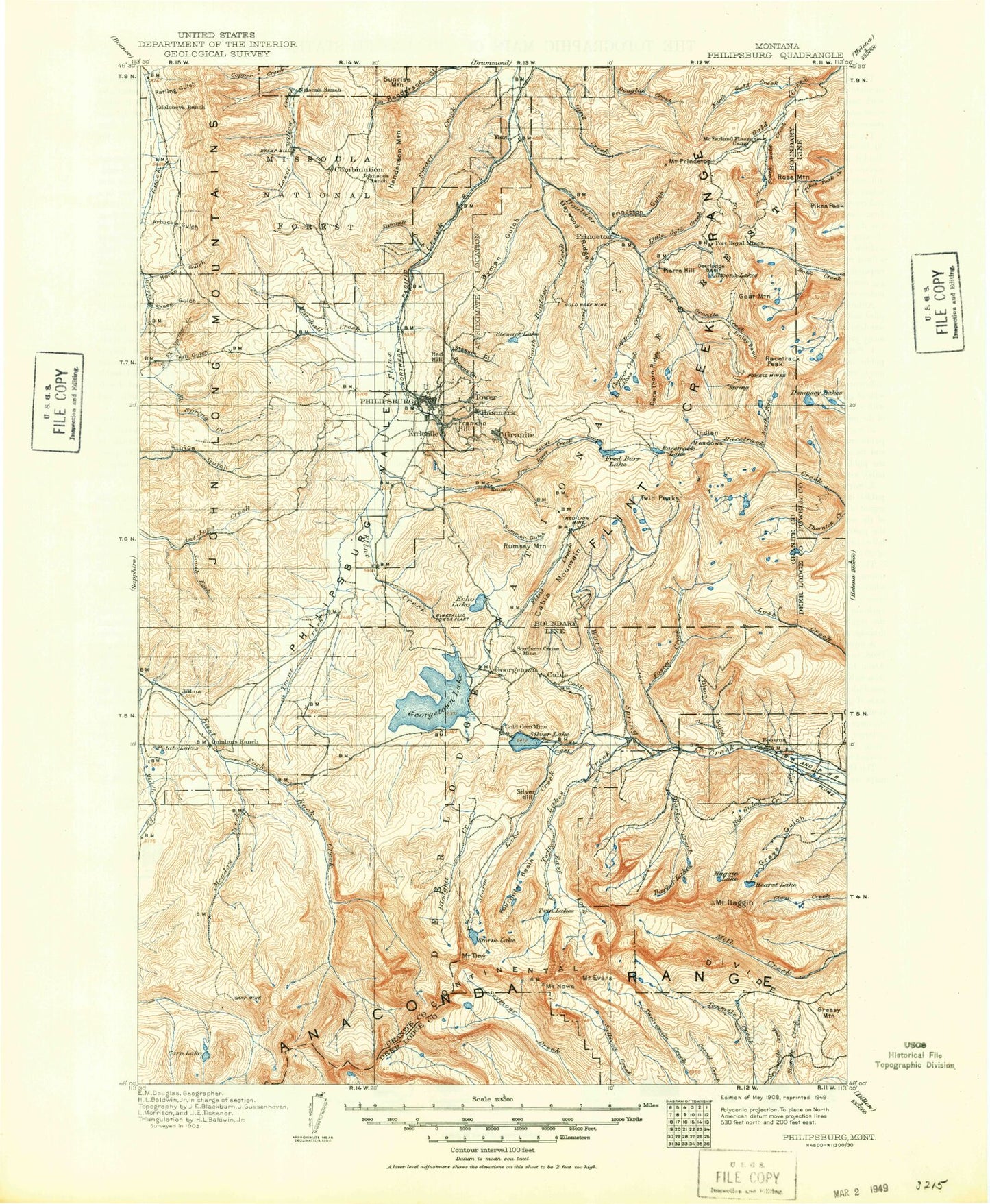
MyTopo
Historic 1908 Philipsburg Montana 30'x30' Topo Map
Couldn't load pickup availability
Historical USGS topographic map of Philipsburg in the state of Montana. Scale: 1:125000. Print size: 18" x 24"
This map was published in 1908 and is in the following counties: Deer Lodge, Granite, Powell.
The map contains contour lines, roads, rivers, towns, streams, and lakes. Printed on high-quality waterproof paper with UV fade-resistant inks.
Contains the following named places: Deerlodge National Forest, Beaver Creek, Albicaulis Lake, Alder Gulch, Alpine Lake, Altoona Lakes, Anaconda Civilan Conservation Center, Anaconda Range, Arbuckle Gulch, Barker Creek, Bathhouse Creek, Bear Creek, Beaverhead Mountain, Bielenberg Lake, Big Gulch, Big Pozega Lake, Big Spring Creek, Black Pine Mine, Black Pine Ridge, Black Pine Ridge Trail Number 6, Blodgett Gulch, Blue Eyed Nellie Gulch, Boulder Creek, Boulder Lakes, Boulder Lakes Trail, Bowman Lakes, Brooklyn Mine, Browns Gulch, Buck Gulch, Bund Gulch, Cable Creek, Cable Mine, Cable Mountain, Cable Mountain Campground, Camp Creek, Camp Silvercloud, Carey Lateral, Carpp Mine, Carpp Ridge, Caruthers Lake, Clay Charlie Gulch, Colter Gulch, Combination Trail Number 3, Copper Creek, Copper Creek, Copper Creek Lakes, Corral Gulch, Cow Creek, Crystal Lake, Cutaway Mountain, Cutaway Pass, Daly Gulch, Daly Lake, Danielsville, Davidson Creek, Day Gulch, Dead Lake, Dearborn Gulch, Deerlodge Basin, Dempsey Basin, Dentons Point, Dexter Basin, Dexter Creek, Dirty Dick Creek, Dora Thorn Lake, Dora Thorn Ridge, Douglas Creek, Douglas Mountain, Dry Creek, Dry Gulch, East Fork Campground, East Fork Reservoir, East Fork Twin Lakes Creek, East Fork Warm Springs Creek, East Goat Mountain, Echo Lake, Elbow Lake, Elk Creek, Emerald Lake, Emery Ridge, Eureka Ridge, Finley Basin, Fish Peak, Fisher Lake, Flint Creek Campground, Flint Creek Canal, Flint Creek Dam, Flower Lake, Foster Creek, Fourmile Basin, Fourmile Basin Lakes, Franklin Hill, Fred Burr Creek, Fred Burr Lake, Fred Burr Pass, Frost Creek, Game Pass, Garrity Mountain, Geary Gulch, George Lake, Georgetown, Georgetown Lake, Goat Flat, Goat Lake, Goat Mountain, Goat Mountain Lakes, Gold Coin Mine, Gold Creek Lakes, Gold Creek Mine, Gold Hill Mine, Granite, Granite Creek, Grassy Mountain, Grays Gulch, Green Lake, Grouse Hill, Haggin Lake, Mount Haggin, Ham Gulch, Hatcher Field, Hearst Lake, Henderson Mountain, Hickey Hill, Hicks Lake, Hidden Lake, Hidden Lake Hill, Hidden Lake Mine, Horseshoe Basin, Huebeck Gulch, Hunters Lake, Ice House Gulch, Indian Meadows, Lake of the Isle, Ivanhoe Mine, John Long Mountains, Johnson Basin, Johnson Hill, Jones Mountain, Kurt Peak, LaMarche Lake, Lagger Gulch, Levengood Gulch, Lion Lake, Little Fred Burr Lake, Little Goat Lake, Little Gold Creek, Little Pozega Lake, Little Racetrack Lake, Little Trout Creek, Lodgepole Campground, Long John Creek, Lost Creek Campground, Lost Creek State Park, Low Pass, Lower Warm Springs Campground, Lower Willow Creek Trail Number Four, Maloney Basin, Maloney Trail Number 5, Marshall Creek, Marshall Creek Canal, Master Mine, Master Mining Camp, Maxville, Maywood Ridge, McDougal Gulch, Meadow Creek, Meadow Lakes, Meadow Lakes, Meyers Dam, Middle Fork Douglas Creek, Middle Fork Warm Springs Creek, Miller Lake, Moonlight Mine, Mount Evans, Mount Howe, Mountain Ben Lake, Mud Lake, Nelson Gulch, Nonpareil Mine, North Fork Douglas Creek, North Fork Flint Creek, North Fork Racetrack Creek, North Fork Spring Creek, North Gold Creek, Olson Gulch, Olson Mountain, One Hundred Acre Meadow, Page Creek, Page Lake, Peterson Meadow, Philipsburg, Philipsburg Bay, Philipsburg Valley, Pickett Gulch, Pierre Hill, Pikes Peak, Pikes Peak Ridge, Pineau Mine, Piney Campground, Piney Point, Porcupine Lake, Porters Corner, Potato Lakes, Powell Mines, Pozega Lakes, Priebe Gulch, Princeton, Princeton Gulch, Mount Princeton, Queener Basin, Queener Mountain, Racetrack Lake, Racetrack Pass, Racetrack Peak, Rainbow Lake, Rainbow Mountain, Rattling Gulch, Red Hill, Red Lion Mine, Red Lion Mountain, Rose Mountain, Royal Gold Creek, Rumsey, Rumsey Mountain, Ryan Mine, Sauer Creek, Sauer Lake, Sawmill Creek, Sawmill Creek, Sheep Gulch, Short Peak, Sidney Lake, Silver Hill, Silver Lake, South Boulder Creek, South Fork Antelope Creek