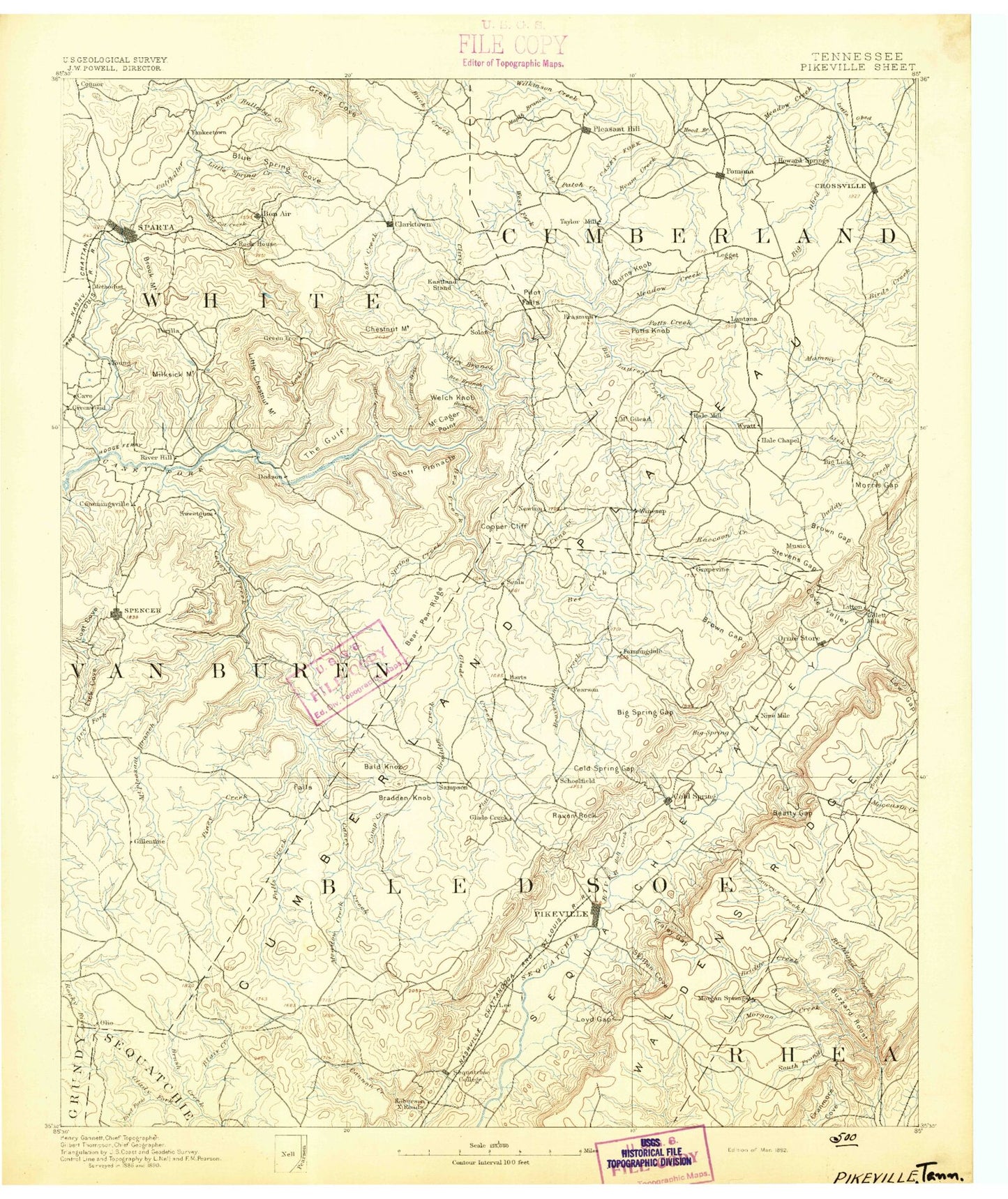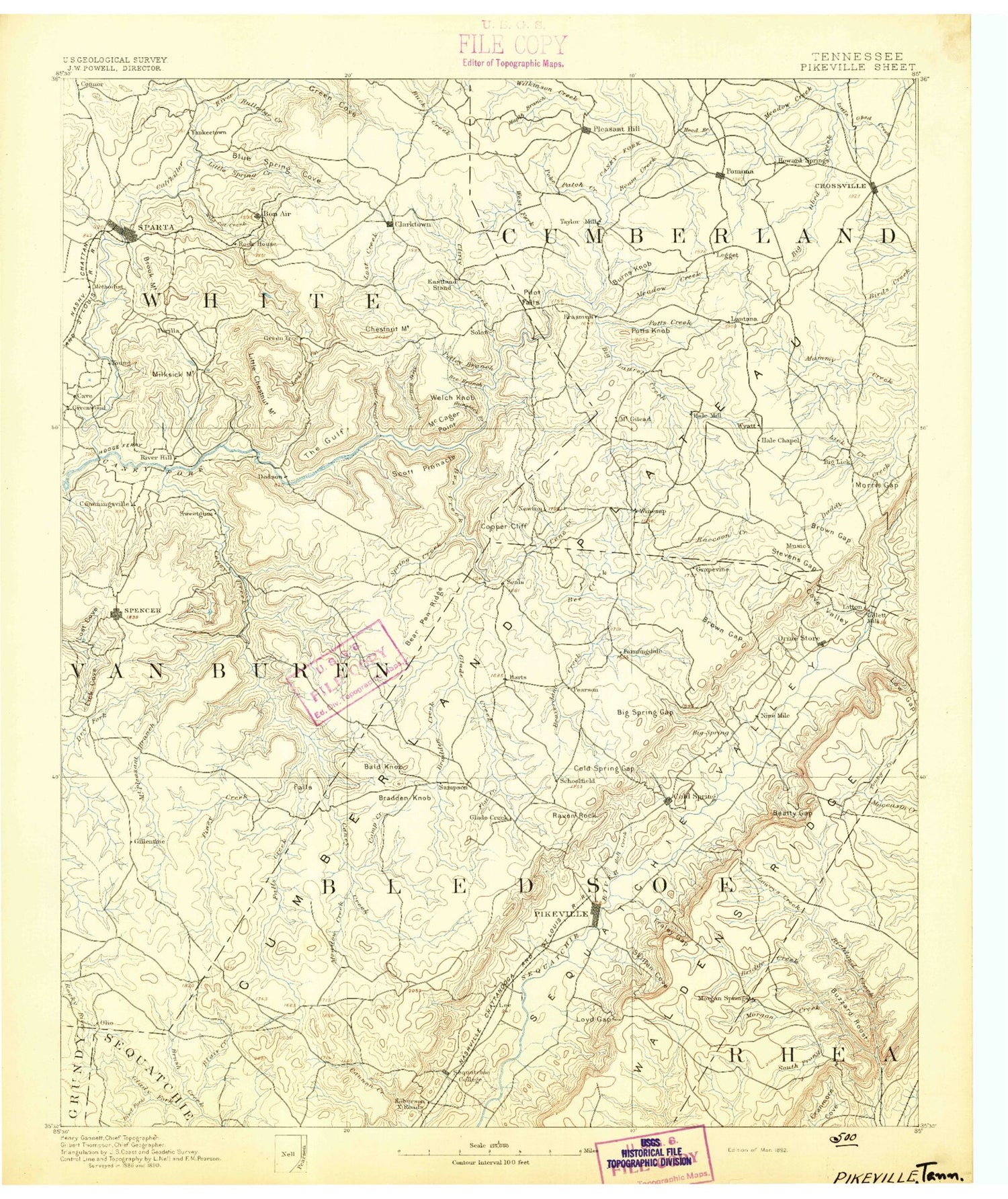
MyTopo
Historic 1892 Pikeville Tennessee 30'x30' Topo Map
Couldn't load pickup availability
Historical USGS topographic map of Pikeville in the state of Tennessee. Scale: 1:125000. Print size: 17" x 24"
This map was published in 1892 and is in the following counties: Bledsoe, Cumberland, Putnam, Rhea, Sequatchie, Van Buren, White.
The map contains contour lines, roads, rivers, towns, streams, and lakes. Printed on high-quality waterproof paper with UV fade-resistant inks.
Contains the following named places: Dog Cove, Sparta, Town Creek, Twin Branch, Baker Mountain, Bear Cove, Big Laurel Creek, Blue Spring Cove, Blue Spring Creek, Brandy Hollow, Buck Creek Lake, Buzzard Mountain, Camp Belle Aire, Camp Shuerman, Cherry Creek, Chestnut Mountain, Clifty Creek, De Rossett, Doe Creek Lake, Findlay, Goulden Mountain, Hasting Cove, Hickory Valley Branch, Little Laurel Creek, Little Lost Creek, Lost Creek, Miller Mountain, Millsea Branch, Plum Creek, Pole Bridge Branch, Polly Branch, Ravenscroft, Rockhouse State Memorial, Davis Lake Number Two, Davis Lake Dam Number Two, Billy Branch Lake, Billy Branch Dam, Wheats Curve Lake Dam, Wheats Curve Lake, Spain Lake Dam, Spain Lake, Payne Lake, Payne Lake Dam, Wonder Lake, Wonder Dam, Doe Creek Lake, Doe Creek Lake Dam, Arrowhead Lake, Arrowhead Lake Dam, Key Acres Lake, Key Acres Dam, Wilkerson Creek, Rockhouse, Simmons Creek, Bledsoe State Forest, Little Mountain, Pine Mountain, Rockhouse Creek, Sheepnose Mountain, Shoemate Gap, Shop Gap, Short Creek, Sinclair Lake, Slaytons Fork, Sloan Branch, Sluter Ridge, Smartt Mountain, Smiths Cove, Snow Falls, Spencer, Spiers Branch, Spring Branch, Spring Branch, Spring Creek, Stillhouse Creek, Suggs Branch, Sullivan Cove, Sulphur Spring Branch, Summer City, Sutherland Ridge, Swafford Branch, Swafford Cove, Swafford Pond, Tamp Gilbert Flat, Tansi Resort, Tantrough Creek, Taylor Branch, The Narrows, Thompson Creek, Thurman Hollow, Tollett Lake, Town Branch, Tucker Knob, Turkey Cot Cove, Turkey Creek, Turner Ridge, Vance Mountain, Virgin Falls, Volunteer Heights, Walden Ridge, Walker Branch, Walker Cove, Walker Gap, Walker Knob, Walkertown Branch, Walling Mill Creek, Watterman Branch, Welch Knob, Weller Branch, West End, West Fork Little Cane Creek, Whetstone Creek, Wheeler Branch, Whiteoak Creek, Whiteoak Swamps, Whiteside Branch, Wilson Branch, Wilson Pen Branch, Wilson Ridge, Wolfpen Branch, Wolfpen Creek, Worthington Knob, Wright Mountain, Zealy Branch, Four-H Club Camp, Little Laurel Creek, Anderson Knob, Anderson Spring Branch, Apple Orchard Branch, Back Creek, Bald Knob, Baltimore Branch, Barber Branch, Barnes Creek, Basin Mountain, Beam Creek, Beatty Cove, Beatty Gap, Beaverdam Branch, Beaverdam Creek, Bee Branch, Bee Creek, Benton Branch, Berkshire Gap, Big Bottom, Big Branch, Big Branch, Big Butte, Big Hill Branch, Big Level, Big Sink, Big Spring Gap, Bills Branch, Bird Fork, Black Drowning Creek, Black Mountain, Black Pond, Blair Creek, Blair Mountain, Board Tree Branch, Bob Creek, Bonner Knob, Bouldin Branch, Bracken Branch, Bradbury Branch, Brock Hollow, Brock Ridge, Brown Gap, Brown Ridge, Browns Creek, Browntown, Bruce Knob, Brush Creek, Bryant Mill Branch, Buck Knob, Buck Ridge, Burnt Field Branch, Buzzard Roost, Byrd Lake, Cane Creek, Cane Creek Falls, Cane Hollow, Card Branch, Cave, Cave Hollow, Cedar Ridge, Chamberlain Knob, Chinquapin Ridge, Clark Gap, Clark Hollow, Clayton Knob, Coalbank Creek, Cold Spring, Cooper Branch, Cooper Creek, Corder Branch, Corner Point, Cove Field Branch, Cowen Branch, Cowen Knob, Crooked Hollow, Cross Mountain, Crystal Creek, Crystal Falls, Cumberland Mountain Lake, Cummings Cove Branch, Dark Hollow, Dark Hollow Branch, Dayton Reservoir, Deadtimber Branch, Deer Hollow Branch, Devils Neck, Devils Racepath, Devilstep Hollow, Dinner Branch, Dogwood Lakes, Dorton Lake, Double Branch, Driver Branch, Dry Creek, Dry Fork, Dugger Branch, Dugger Hill, Dumpling Mountain, Duncan Creek, Durham Branch, Dutchmans Knob, East Fork Little Cane Creek, Eden Branch, Fall Creek, Fall Creek Falls, Group Camp 1, Fall Creek Falls State Park, Farmers Creek, Flat Creek, Flat Gap