MyTopo
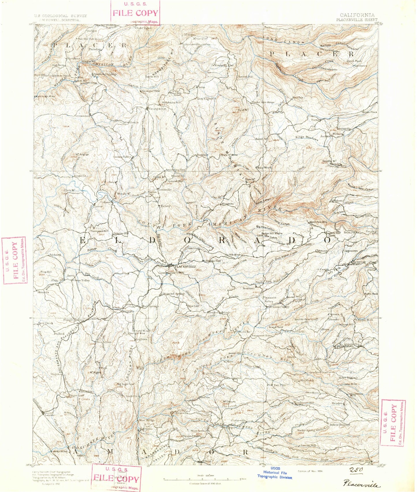
Historic 1891 Placerville California 30'x30' Topo Map
Couldn't load pickup availability
Historical USGS topographic map of Placerville in the state of California. Scale: 1:125000. Print size: 17" x 24"
This map was published in 1891 and is in the following counties: Amador, El Dorado, Placer.
The map contains contour lines, roads, rivers, towns, streams, and lakes. Printed on high-quality waterproof paper with UV fade-resistant inks.
Contains the following named places: Pinehem Creek, Mount Aigare, Al Brass Creek, American River Flume, Mount Ararat, Mount Aukum, Bacchi Ranch, Bacon Canyon, Badger Hill Mine, Bald Mountain, Bald Mountain Canyon, Ballarat Canyon, Baltic Creek, Baltic Peak, Bedrock Mine, Bell Ranch, Big Butte, Big Canyon, Big Canyon, Big Canyon Creek, Big Canyon Mine, Big Indian Creek, Big Mountain, Blodgett Experimental Forest, Blue Gouge Mine, Blue Tent Creek, Bluebird Mine, Boedner Mine, Boles Gap, Bootjack Mine, Boulder Mine, Briarcliff Mines, Brush Creek, Brush Creek, Brushy Canyon, Buckeye Flat, Bugtown Mine, Burnt Shanty Creek, Cable Point, Camp Forward, Canyon Creek, Cedar Canyon, Cedar Ravine, Cedarville, China Mountain, Chiquita Lake, Chuck Ravine, Church Mine, Clark Creek, Clark Creek, Clark Mountain, Connor Cabin, Coon Hollow, Cooper Mine, Copper Hill Mine, Cosumnes Mine, Coyote Ridge, Crusader Mine, Crystal Mine, D'Agostini Ranch, Dark Canyon, Deadman Creek, Deep Canyon, Delores Mine, Diamond Creek, Ditch Camp Point, Dry Creek, Dutch Canyon, Eagle King Mine, Eagle Mine, East Big Canyon Creek, El Dorado, El Dorado County Fairgrounds, Fanny Creek, Fiddletown, Flat Creek, Fleming Meadow, French Creek, Funny Bug Mine, Gaddis Creek, Gambler Creek, Gilmore Creek, Marshall Gold Discovery State Historic Park, Gold Hill, Golden Treasure Mine, Granite Canyon, Granite Creek, Grapevine Ravine, Greenstone Mine, Grizzly Gulch, Hangtown Creek, Hanks Exchange, Hastings Creek, Hazel Creek, Hazel Creek Mine, Humbug Mine, Hungry Hollow, Independence Point, Indian Creek, Indian Creek, Iowa Canyon, Iowa Hill, Irish Gulch, Jacobs Creek, James W Marshall State Historical Monument, Jayhawk Creek, Johnson Mine, Josephine Canyon, Kelley Creek, Kenna Mine, Kenny Mine, Kentucky Flat, Larsen Reservoir, Lichen Creek, Lilyama Mine, Little Butte, Little Gambler Creek, Little Indian Creek, Little Silver Creek, Logtown Ridge, Long Canyon, Long Canyon, Long Gulch, Lookout Mine, Lost Canyon Creek, Marble Creek, Marble Valley, Marcelais Mine, Marshall Mine, Martinez Creek, Middle Butte, Mill Creek, Mill Pond, Miller Ranch, Missouri Flat, Moco Canyon, Mormon Ravine, Morton Ranch, Mound Springs Creek, Mount Hope Mine, Mutton Canyon, Nevada Point Trail, North Canyon, North Canyon, North Fork Clear Creek, North Fork Extension Ditch, North Fork One Eye Creek, North Fork Spanish Creek, Norton Ravine, Peavine Point, Pennsylvania Point, Perry Mountain Creek, Pilot Creek, Pine Hill, Plymouth Ditch, Post Flat, Pyramid Mine, Randalls Mine, Redbird Canyon, Redbird Creek, Rescue, Sailor Ravine, Sand Mountain, Sawmill Creek, Shaw Mine, Shaw Mine Mill, Shenandoah Valley, Shingle Creek, Shingle Creek, Shingle Mill Gulch, Shingle Springs Rancheria, Slab Creek, Slab Creek Reservoir, Slate Canyon, Slate Creek, Slate Creek, Slate Creek, Slate Mountain, Slate Mountain Mine, Slate Mountains, Slug Gulch, Sly Park Dam, Sly Park Guard Station, Lawrence Mill, Michigan Bar Ditch, Pigeon Creek, Snowline Camp, Soapweed Creek, South Canyon, South Fork One Eye Creek, South Fork Spanish Creek, Spanish Creek, Spanish Ravine, Spring Canyon, Spring Flat, Squaw Flat, Stafford Creek, Starlight Mine, Steely Fork Cosumnes River, Stonebreaker Creek, Stoney Creek, String Canyon, Sturdevant Ridge, Sugarloaf, Sugarloaf, Sugarloaf Mine, Sutters Mill, Tennessee Creek, Tennessee Creek, Texas Creek, Texas Hill, Thompson Hill, Ticky Creek, Tiedman Mine, Tipton Hill, Tunnel Creek, Tunnel Hill, Umatilla Mine, Union Mine, Vandalia Mine, Water Canyon, Whaler Creek, White Man Ravine, White Oak Creek, White Oak Flat, White Oak Point, Wisconsin Gulch, Woodpecker Gulch, Yankee John Creek, Middle Fork Cosumnes River, Brandon Corner, Cold Springs, Dugan, Kingsville, Pino Grande, Soapweed