MyTopo
Historic 1894 Pocahontas Virginia 30'x30' Topo Map
Couldn't load pickup availability
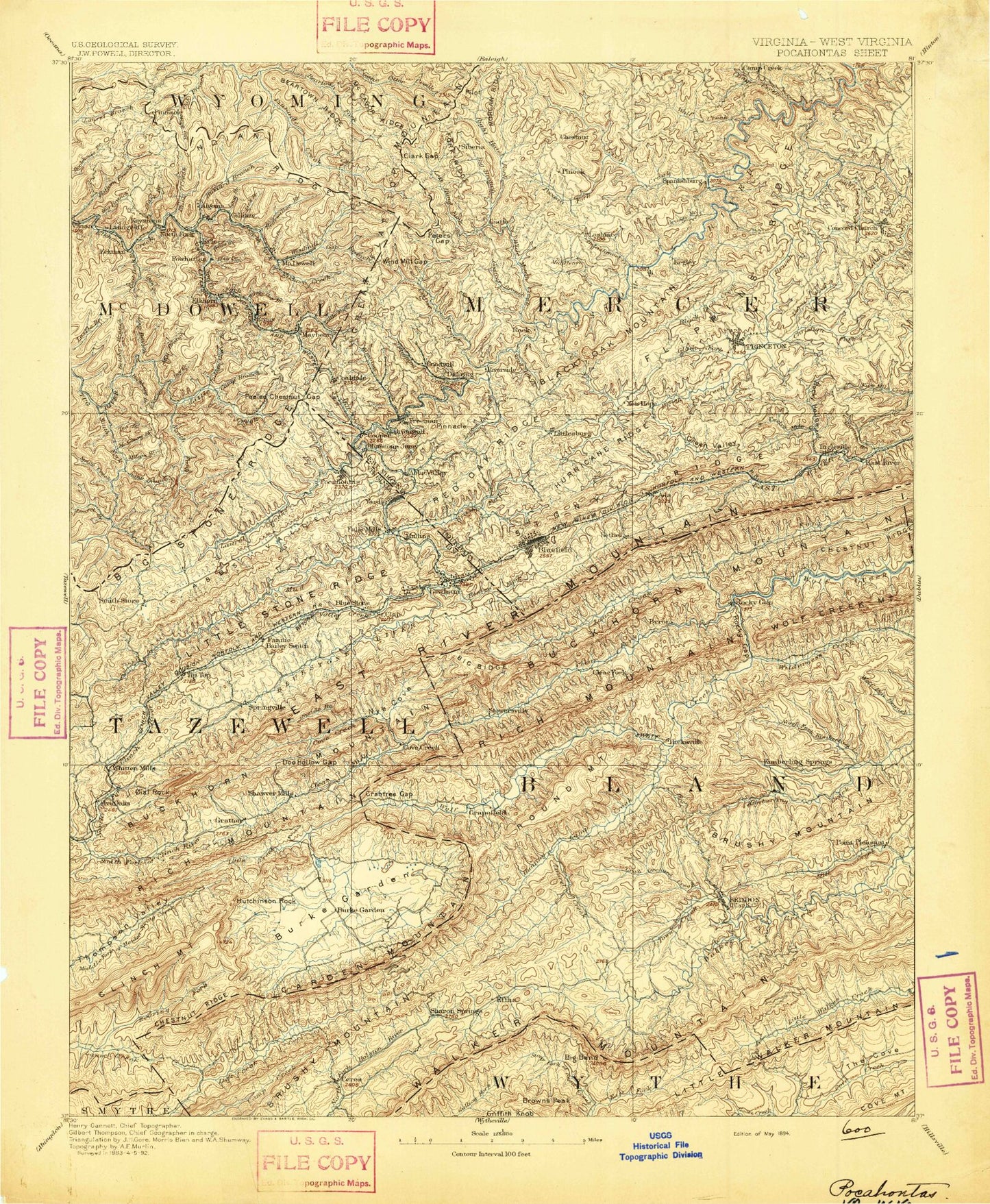
Historical USGS topographic map of Pocahontas in the state of Virginia. Scale: 1:125000. Print size: 17" x 24"
This map was published in 1894 and is in the following counties: Bland, Giles, McDowell, Mercer, Smyth, Tazewell, Wyoming, Wythe.
The map contains contour lines, roads, rivers, towns, streams, and lakes. Printed on high-quality waterproof paper with UV fade-resistant inks.
Contains the following named places: Big Branch, Big Stone Ridge, Brush Fork, Curran Branch, Falls Mills Dam, Farmers Branch, Haynes Branch, Jonathan Branch, Low Gap, Neal Hollow, Peeled Chestnut Gap, Pocahontas Mine, Pratter Hollow, Reeds Branch, Yards, Tabors, Abbs Valley, Abbs Valley Ridge, Alder Cabin Branch, Alum Spring Hollow, Banks Ridge, Barkcamp Branch, Beartown Ridge, Beaverpond Creek, Big Bend, Big Branch, Big Ridge, Blue Spring Creek, Bluefield, Bluefield City Park, Bobs Spur, Bowen Field, Broad Hollow, Bucks Branch, Burkes Garden, Burkes Garden Creek, Camp Joy, Camp Laurel, Camp Roland, Carter Branch, Chestnut Ridge, Chestnut Ridge, Clear Fork, Clear Spring Branch, Clinch Valley, Coon Branch, Cove Branch, Cove Creek, Cox Branch, Crab Orchard Creek, Crabtree Gap, Crag Hollow, Crooked Run, Dalton Branch, Dark Hollow, Deavers Branch, Dry Fork, East Fork Cove Creek, East Fork Stony Fork, Effna, Farling Hollow, Foglesong Valley, Fox Branch, Garden Mountain, Gose Branch, Gose Knob, Gratton, Griffith Knob, Hall Ridge, Havens Spur, Helveys Mill Creek, Hemppatch Branch, Heninger Gap, Hogback, Hunting Camp Creek, Indianfield Branch, Jacobs Hollow, John Spur, Kidd Branch, Kimberling, Knot Mole Branch, Lambert Hollow, Laurel Branch, Laurel Branch, Laurel Creek, Laurel Creek, Laurel Fork, Laurel Hollow, Little Creek, Little Valley Ridge, Little Walker Mountain, Little Wolf Creek, Long Spur, Lost Ridge, Low Gap, Lynn Hollow, Medley Valley, Mill Branch, Mill Ridge, Mud Fork, Mudley Branch, North Fork Clinch River, North Fork Kimberling Creek, North Gap, North Hollow, Nye Cove, Oneida Branch, Opossum Hollow, Perry Branch, Pine Spur, Point Pleasant, Puckett Hollow, Pumpkin Center, Rattlesnake Hollow, Redoak Ridge, Rhudy Branch, Roaring Fork, Rocky Gap, Rocky Gap, Round Mountain, Big Ridge, Punch and Judy Creek, Wrights Valley, Wrights Valley Creek, Wynne Peak, Yokel Branch, Yokel Ridge, Shewey Valley, Six Hollow, Slickrock Branch, Snag Hollow, Snyder Branch, Soap Creek, South Fork Clinch River, South Gap, Station Spring Creek, Station Spring Creek, Stony Ridge, Sulphur Spring Fork, Tazewell County Sportsmen Club Lake, Tazewell Reservoir, Teels Branch, The Gap, Tiptop, Totten Branch, Town Creek, Turkey Gap, Wagner Trace Branch, Walker Gap, Walker Mountain, West Fork Cove Creek, Wilderness Creek, Wittens Mills, Walker Mountain Trail, Jenkins Shelter, Walker Mountain Lookout, Dear Trail Park Campground, Knot Mole Shelter, Big Bend Picnic Area, Stony Fork Campground, White Creek Picnic Area, Kimberling Creek Wilderness, Gullion Fork Fishing Ponds, East River Mountain Tunnel, Hunting Camp Dam, Crab Orchard Creek Dam, Upper Clinch River Number Eight Dam, Sportsman Club Dam, Gose Mill Dam, Fincastle Country Club, Prison Camp Number 31, Richwood Golf Club, Bastian, Bernietown, Big Vein, Boissevain, Carnot, Clear Fork, Cove Creek, Falls Mills, Grapefield, Hales Bottom, Hereford, Hicksville, Pocahontas, Saint Clair, Sam, Scott Knob, Shannandale, Gose Mill, Shawver Mill, Suiter, Big Walker Mountain Tunnel, Bland County, Bob King Branch, Byron, Church Branch, Crab Orchard Lake, Creed Branch, Eagle Oak, East River Mountain Tunnel, The Flatwoods, Lynn Hollow Branch, Middle Fork Kimberling Creek, Polly Branch, Poplar Spring Branch, Roof Branch, Stowersville, Surrat Branch, Town Ridge, Waterfall Branch, Ceres, Little Town, Sharon Springs, Bald Hill, Ghost Knob, Hutchinson Rock, Lynn Camp Mountain, Rich Mountain, Steel Hill, Bluefield Industrial Park, Burkes Garden Rural Historic District, Burtons Shop, Coal Run, College Plaza Shopping Center, Cumberland Plaza Shopping Center, Falls Mills Lake, Joe Neets, Pocahontas Historic District, Spracher Place, Twin City Shopping Center, West Graham, Westgate Shopping Center, Burkes Garden, Bland, Abbs Valley